Piqua in Miami County, Ohio — The American Midwest (Great Lakes)
Public Square
Sign of the Past
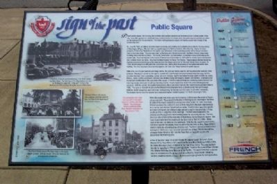
Piqua's public square, like in many mid-western communities, functions as the historical and cultural center of the city. Long after government buildings have moved to newer and larger sites, the public square maintains its status as the focal point of the community. The history of Piqua's public square mirrors the growth and change of the community itself.
On June 29, 1807, Armstrong Brandon began surveying and plotting one hundred and one lots for the new village of Washington (Piqua). Brandon laid out a public square on land donated by John Manning. Due to the close proximity of the Great Miami River, the square was not located in the customary center of the village but rather near its southern edge. The area was given by Manning with the stipulation that the Miami County government buildings would be erected there. The county commission decided instead to establish a new community as the county seat. Troy was laid out in the center of the county in December of 1807 with the county courts setting into the Overfield Tavern in 1808. This was the beginning of the Piqua-Troy Rivalry. Piqua's square did not receive its desired government buildings so the area became the village commmons for the next twenty-five or so years. In 1834, the Manning heirs attempted to reclaim the land, stating that the purpose of the square had never been fulfilled. The Ohio Supreme Court decided against this claim and Piqua retained its public square.
Before the era of super markets and mega-stores, the open air market was the primary source for meat and fresh produce. The square served as this type of market with local farmers bringing in everything from eggs and the chickens that laid them to potatoes, apples and corn whiskey used to help ease the long nights in drafty log cabins. Horses, mules and the occasional bull were also traded among the villagers, dealers and farmers. A frame market house was constructed on the east side of the square in 1818 to help facilitate the increasing crowds for both the morning market times and the all day Saturday market. It was replaced in 1850 with a new and larger brick structure. With the growth of neighborhood grocery stores and meat markets, the market house was torn down in 1882. The open air market returned on Wednesdays and Saturdays from 5:00 AM to 8:00 PM April through October. Booth space fees were set at ten cents per day for farmers and fifty cents for all other individuals. The market moved from the square to a newly constructed market house at 101 North Downing in 1928.
While the square was never used by the county, it did become the center of Piqua's city government. Piqua ended the tradition of holding council meetings in the office or store
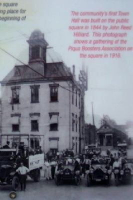
of the mayor and built its own government center. In 1844, John Reed Hilliard was given the contract to erect a three story brick structure, approximately forty feet by sixty feet and topped with a cupola. The third story was not originally included, but Piqua's Odd Fellows Lodge agreed to pay for the added story if they could use it for a Lodge Hall in the evenings. The town council agreed to the proposal and Piqua gained a free meeting space for use during the day. The new structure was located on the east side of Main Street, facing the public square. The town council held their first meeting in the Town Hall on March 3, 1845. When pigeons became a problem on the building in 1852, the city council suspended the ordinance against discharging firearms within the city limits to allow Mayor William Elliott to shoot the offending birds off of the roof. The Town Hall was remodeled and enlarged in 1886 and a new mansard style roof was added. The city moved their offices to Water Street in 1927 and the Town Hall on the public square was demolished the following year.
A few of the other major structures around the square include Conover's Opera House (1872), Plaza Hotel (1891), two Piqua National Bank Buildings (1898)(1929), St. James Episcopal Church (1900) and the Post Office (1914). The area has been the site for speeches by William Jennings Bryan, Theodore Roosevelt, William
Photographed By William Fischer, Jr., March 6, 2008
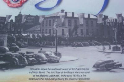
3. Southwest Corner of Public Square
This photo shows the southwest corner of the Public Square and Main Street. The third flood of the Rapp's store was used as a Masonic Lodge hall. In the early 1970's, a fire destroyed all of the buildings facing the square at this corner.
Erected 2008 by Flesh Public Library and French Oil Mill Machinery Company.
Topics and series. This historical marker is listed in these topic lists: Agriculture • Charity & Public Work • Fraternal or Sororal Organizations • Settlements & Settlers. In addition, it is included in the Former U.S. Presidents: #25 William McKinley, the Former U.S. Presidents: #26 Theodore Roosevelt, and the Former U.S. Presidents: #27 William Howard Taft series lists. A significant historical month for this entry is March 1958.
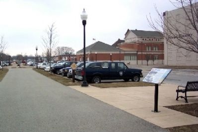
Location. 40° 8.803′ N, 84° 14.393′ W. Marker is in Piqua, Ohio, in Miami County. Marker can be reached from Main Street. Marker is along former east-west railroad grade, bounded by Main Street (east), Wayne Street (west), Water Street (north), and Wood Street (south). Touch for map. Marker is in this post office area: Piqua OH 45356, United States of America. Touch for directions.
Other nearby markers. At least 8 other markers are within walking distance of this marker. Main Street (within shouting distance of this marker); The 1913 Flood (about 400 feet away, measured in a direct line); Lock Nine
Photographed By William Fischer, Jr., March 6, 2008
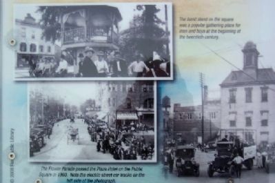
4. Band Stand and Parade on Public Square Marker
The band stand on the square was a popular gathering place for men and boys at the beginning of the twentieth century.
The Flower Parade passed the Plaza Hotel on the Public Square in 1900. Note the electric street car tracks on the left side of the photograph.
The Flower Parade passed the Plaza Hotel on the Public Square in 1900. Note the electric street car tracks on the left side of the photograph.
Credits. This page was last revised on August 1, 2020. It was originally submitted on March 26, 2009, by William Fischer, Jr. of Scranton, Pennsylvania. This page has been viewed 1,040 times since then and 17 times this year. Photos: 1, 2, 3, 4, 5. submitted on March 26, 2009, by William Fischer, Jr. of Scranton, Pennsylvania. • Bill Pfingsten was the editor who published this page.
