Merriam Park West in Saint Paul in Ramsey County, Minnesota — The American Midwest (Upper Plains)
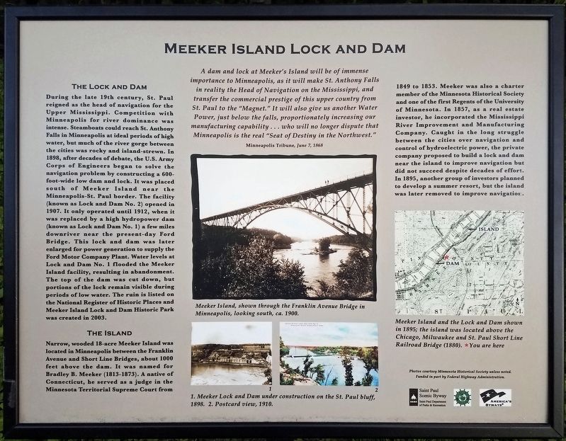
Meeker Island Lock and Dam
Minneapolis Tribune, June 7, 1868
The Lock and Dam
During the late 19th century, St. Paul reigned as the head of navigation for the Upper Mississippi. Competition with Minneapolis for river dominance was intense. Steamboats could reach St. Anthony Falls in Minneapolis at ideal periods of high water, but much of the river gorge between the cities was rocky and island-strewn. In 1898, after decades of debate, the U.S. Army Corps of Engineers began to solve the navigation problem by constructing a 600-foot-wide low dam and lock. It was placed south of Meeker Island near the Minneapolis-St. Paul border. The facility (known as Lock and Dam No. 2) opened in 1907. It only operated until 1912, when it was replaced by a high hydropower dam (known as Lock and Dam No. 1) a few miles downriver near the present day Ford Bridge. This lock and dam was later enlarged for power generation to supply the Ford Motor Company Plant. Water levels at Lock and Dam No. 1 flooded the Meeker Island facility, resulting in abandonment. The top of the dam was cut down, but portions of the lock remain visible during periods of low water. The ruin is listed on the National Register of Historic Places and Meeker Island Lock and Dam Historic Park was created in 2003.
The Island
Narrow, wooded 18-acre Meeker Island was located in Minneapolis between the Franklin Avenue and Short Line Bridges, about 1000 feet above the dam. It was named for Bradley B. Meeker (1813-1873). A native of Connecticut, he served as a judge in the Minnesota Territorial Supreme Court from 1849 to 1853. Meeker was also a charter member of the Minnesota Historical Society and one of the first Regents of the University of Minnesota. In 1857, as a real estate investor, he incorporated the Mississippi River Improvement and Manufacturing Company. Caught in the long struggle between the cities over navigation and control of hydroelectric power, the private company proposed to build a lock and dam near the island to improve navigation but did not succeed despite decades of effort. In 1895, another group of investors planned to develop a summer resort, but the island was later removed to improve navigation.
Erected by Saint Paul Department of Parks and Recreation.
Topics. This historical marker is listed in these topic lists: Industry & Commerce • Waterways & Vessels. A significant historical year for this entry is 1898.
Location. 44° 57.245′ N, 93° 12.397′ W. Marker is in Saint Paul, Minnesota, in Ramsey County. It is in Merriam Park West. Marker is on Mississippi River Boulevard north of Eustis Street, on the left when traveling north. Marker is just off the footpath parallel to Mississippi River Boulevard. A trail down to the lock and dam site begins nearby. Touch for map. Marker is at or near this postal address: 486 N Mississippi River Blvd, Saint Paul MN 55104, United States of America. Touch for directions.
Other nearby markers. At least 8 other markers are within walking distance of this marker. Meeker Island Lock and Dam Historic Site (a few steps from this marker); Mississippi River (approx. 0.2 miles away); Roar of Waterfall, Rush of Rapids (approx. ¼ mile away); Sri Chinmoy Peace Bridge (approx. 0.4 miles away); Bridging the Mississippi (approx. 0.4 miles away); Sesquicentennial Trees (approx. half a mile away); The Red River Ox Cart Trail (approx. half a mile away); Minneapolis War Memorial Blood Bank (approx. 0.7 miles away). Touch for a list and map of all markers in Saint Paul.
Credits. This page was last revised on February 12, 2023. It was originally submitted on May 23, 2021, by McGhiever of Minneapolis, Minnesota. This page has been viewed 187 times since then and 20 times this year. Photos: 1, 2. submitted on May 23, 2021, by McGhiever of Minneapolis, Minnesota. • Mark Hilton was the editor who published this page.

