Parkers Crossroads in Henderson County, Tennessee — The American South (East South Central)
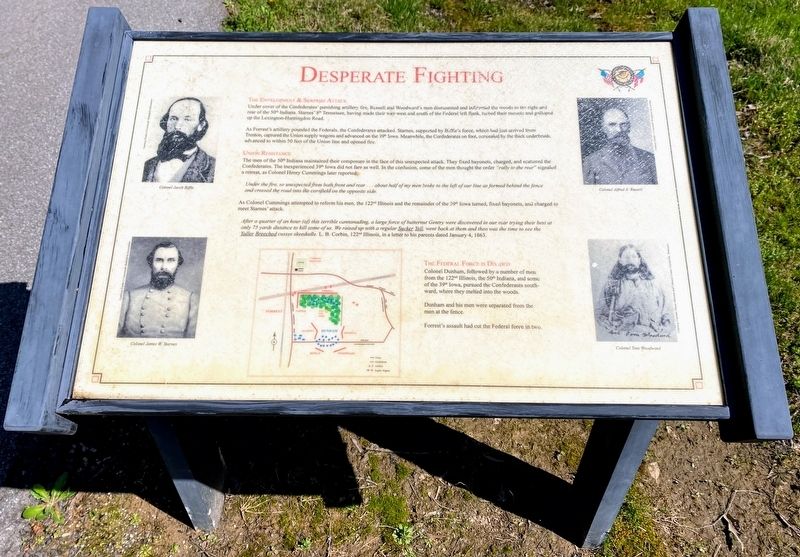
Desperate Fighting
The Envelopment & Surprise Attack
Under cover of the Confederates' punishing artillery fire, Russell and Woodward's men dismounted and infiltrated the woods to the right and rear of the 50th Indiana. Starnes' 8th Tennessee, having made their way west and south of the Federal left flank, turned their mounts and galloped up the Lexington-Huntingdon Road.
As Forrest's artillery pounded the Federals, the Confederates attacked. Starnes, supported by Biffle's force which had just arrived from Trenton, captured the Union supply wagons and advanced on the 39th Iowa. Meanwhile, the Confederates on foot, concealed by the thick underbrush, advanced to within 50 feet of the Union line and opened fire.
Union Resistance
The men of the 50th Indiana maintained their composure in the face of this unexpected attack. They fixed bayonets, charged, and scattered the Confederates. The inexperienced 39th Iowa did not fare as well. In the confusion, some of the men thought the order "rally to the rear" signaled a retreat, as Colonel Henry Cummings later reported:
Under the fire, so unexpected from both front and rear...about half of my men broke to the left of our line as formed behind the fence and crossed the road into the cornfield on the opposite side.
As Colonel Cummings attempted to reform his men, the 122nd Illinois and the remainder of the 39th Iowa turned, fixed bayonets, and charged to meet Starnes' attack.
After a quarter of an hour (of) this terrible cannonading, a large force of butternut Gentry were discovered in our rear trying their best at only 75 yards distance to kill some of us. We raised up with a regular Sucker Yell, went back at them and then was the time to see the Yaller Breeched cusses skeedadle. L. B. Corbin, 122nd Illinois, in a letter to his parents dated January 4, 1863.
The Federal Force is Divided
Colonel Dunham, followed by a number of men from the 122nd Illinois, the 50th Indiana, and some of the 39th Iowa, pursued the Confederates southward, where they melted into the woods.
Dunham and his men were separated from the men at the fence.
Forrest's assault had cut the Federal force in two.
(captions)
Colonel Jacob Biffle
Colonel James W. Starnes
Colonel Alfred A. Russell
Colonel Tom Woodward
Erected by Parker's Crossroads Battlefield Association.
Topics. This historical marker is listed in this topic list: War, US Civil. A significant historical date for this entry is December 31, 1862.
Location. 35° 47.249′ N, 88° 23.184′ W. Marker is in Parkers Crossroads, Tennessee, in Henderson County. Marker is on Federal Lane, 0.2 miles east of Tennessee Route 22, on the right when traveling east. Marker is located along the South Battlefield Trail, at Auto Tour Stop No. 7 of the Parker's Crossroads Battlefield Auto Tour. Touch for map. Marker is in this post office area: Wildersville TN 38388, United States of America. Touch for directions.
Other nearby markers. At least 8 other markers are within walking distance of this marker. "The General Demands An Unconditional Surrender" (within shouting distance of this marker); Cyrus Livingston Dunham (about 300 feet away, measured in a direct line); Union Cemetery (about 400 feet away); 18th Illinois Mounted Infantry (about 400 feet away); 50th Indiana Infantry Regiment (about 400 feet away); Freeman's Battery (about 400 feet away); Forrest's Artillery (about 400 feet away); A Concealed Assault (about 500 feet away). Touch for a list and map of all markers in Parkers Crossroads.
Also see . . . Parker's Crossroads Battlefield Association. (Submitted on May 30, 2021.)
Credits. This page was last revised on July 24, 2021. It was originally submitted on May 28, 2021, by Shane Oliver of Richmond, Virginia. This page has been viewed 197 times since then and 25 times this year. Photos: 1. submitted on May 28, 2021, by Shane Oliver of Richmond, Virginia. 2. submitted on July 24, 2021, by Darren Jefferson Clay of Duluth, Georgia. • Bernard Fisher was the editor who published this page.

