Near Gering in Scotts Bluff County, Nebraska — The American Midwest (Upper Plains)
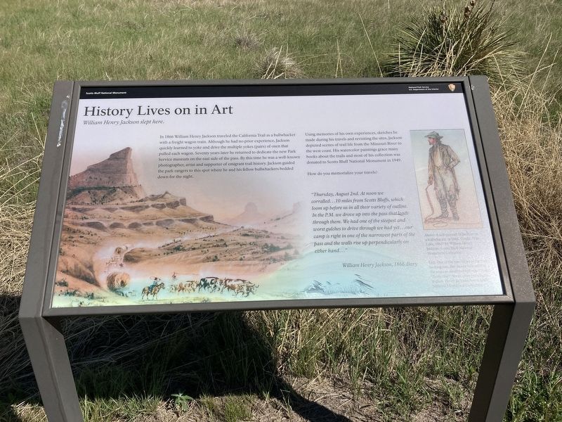
History Lives on in Art
William Henry Jackson slept here.
| — | Scotts Bluff National Monument | — |
Photographed by Connor Olson, May 25, 2021
1. History Lives on in Art Marker
In 1866 William Henry Jackson traveled the California Trail as a bullwhacker with a freight wagon train. Although he had no prior experience, Jackson quickly learned to yoke and drive the multiple yokes (pairs) of oxen that pulled each wagon. Seventy years later he returned to dedicate the new Park Service museum on the east side of the pass. By this time he was a well-known photographer, artist and supporter of emigrant trail history. Jackson guided the park rangers to this spot where he and his fellow bullwhackers bedded down for the night.
Using memories of his own experiences, sketches he made during his travels and revisiting the sites, Jackson depicted scenes of trail life from the Missouri River to the west coast. His watercolor paintings grace many books about the trails and most of his collection was donated to Scotts Bluff National Monument in 1949.
How do you memorialize your travels?
“Thursday, August 2nd. At noon we corralled…10 miles from Scotts Bluffs, which loom up before us in all their variety of outline. In the P.M. we drove up into the pass that leads through them. We had one of the steepest and worst gulches to drive through we had yet…our camp is right in one of the narrowest parts of the pass and the walls rise up perpendicularly on either hand…"
WilliamHenry Jackson, 1866 diary
Click or scan to see
this page online
[Captions:]
A self-portrait of Jackson as a bullwhacker in 1866.
One of the rare views of the trail looking east, this shows how narrow the route was around the bluff was.
Erected by National Park Service, U.S. Department of the Interior.
Topics. This historical marker is listed in these topic lists: Arts, Letters, Music • Roads & Vehicles • Settlements & Settlers. A significant historical year for this entry is 1866.
Location. 41° 49.941′ N, 103° 42.731′ W. Marker is near Gering, Nebraska, in Scotts Bluff County. It can be reached from Old Oregon Trail (County Highway K) 2.3 miles west of Meadowlark Boulevard, on the right when traveling west. The marker stands along the old Oregon Trail. Touch for map. Marker is at or near this postal address: 190276 Old Oregon Trail, Gering NE 69341, United States of America. Touch for directions.

Regionally, this marker is in the Nebraska Panhandle. It is also in the American Midwest, in the Corn Belt, and on the prairies. Globally, it is in North America, the Western Hemisphere, the Western World, and the Anglosphere. Historically,
Photographed by Connor Olson, May 25, 2021
2. History Lives on in Art Marker
Other nearby markers. At least 8 other markers are within walking distance of this marker: Assistance on the Trail (here, next to this marker); Oregon Trail (about 400 feet away, measured in a direct line); A Transportation Corridor (approx. 0.2 miles away); Choices (approx. 0.3 miles away); Scott's Bluff Pony Express Station (approx. 0.4 miles away); A Landscape Changed Forever (approx. 0.7 miles away); Before the Wagons (approx. 0.7 miles away); The Many Faces of the Trail (approx. 0.7 miles away). Touch for a list and map of all markers in Gering.
Other markers no longer nearby. The Bullwhackers (was here, next to this marker but has been permanently removed); Traces of the Trail (was approx. 0.2 miles away but has been replaced with another marker now near it); a different marker also named Oregon Trail (was approx. 0.3 miles away but has been permanently removed); Scotts Bluff (was approx. 0.7 miles away but has been permanently removed); Pony Express (was approx. 0.7 miles away but has been permanently removed); The Overland Experience (was approx. 0.7 miles away but has been permanently removed).
Credits. This page was last revised on September 7, 2021. It was originally submitted on June 2, 2021, by Connor Olson of Menomonee Falls, Wisconsin. This page has been viewed 249 times since then and 16 times this year. Photos: 1, 2. submitted on June 2, 2021, by Connor Olson of Menomonee Falls, Wisconsin. • Devry Becker Jones was the editor who published this page.
