Delaware City in New Castle County, Delaware — The American Northeast (Mid-Atlantic)
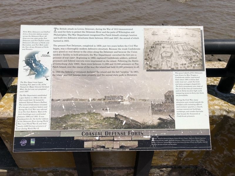
Coastal Defense Forts
The British attack on Lewes, Delaware, during the War of 1812 demonstrated the need for forts to protect the Delaware River and the ports of Wilmington and Philadelphia. The War Department recognized Pea Patch Island's strategic location and built two defensive structures there between 1813 and 1827, the second of which burned in 1831.
The present Fort Delaware, completed in 1859, just two years before the Civil War began, was a thoroughly modern defensive structure. Because the weak Confederate navy posed no real threat to the cities along the Delaware and because the Union needed a facility to hold prisoners, the War Department converted the fort into a prisoner of war camp. Beginning in 1862, captured Confederate soldiers, political prisoners and federal convicts were imprisoned on the island. Following the Battle of Gettysburg (July 1863), there were between 11,000 and 12,000 prisoners on Pea Patch Island; over the course of the war, the island had held 33,000 prisoners in all.
In 1945 the federal government declared the island and the fort "surplus." In 1951, the island and fort became state property and the second state park in Delaware.
[Captions:]
Forts Mott, Delaware and DuPont form a three-fort defense system across the Delaware River. All three are now state parks, Fort Delaware and Fort DuPont under Delaware's Division of Parks and Recreation, and Fort Mott under the New Jersey Division of Parks and Forestry.
The War Department began building Fort Mott in the 1870s. Named for Major General Gershom Mott, the fort was not completed until 1897.
The War Department established a gun battery in 1863 on the site that would later be named for Admiral Samuel Francis DuPont. The initial fortifications consisted of a ten-gun auxiliary battery and during the Civil War was referred to as Ten Gun Battery. Most of the fort's buildings were constructed between 1898 and 1901. It was headquarters for the harbor defense of the Delaware River during World War I and World War II, and held nearly 3,000 German prisoners of war during World War II.
This pencil sketch of Fort Delaware was drawn by Max Neugas, a Confederate soldier imprisoned there about 1864. A thirty-foot-wide moat surrounds the brick and stone pentagon-shaped fort. The fort's armaments were state of the art at the time of construction and its thirty-two-foot high walls measuring seven to thirty feet thick, are formidable.
During the Civil War, many structures were erected outside the fortified walls including officers' and civilians' quarters, a church, various commercial buildings, workshops, and wooden barracks that housed the thousands of Confederate
Erected by City of Delaware City, Delaware; Delaware Land & Water Conservation Trust Fund.
Topics. This historical marker is listed in these topic lists: Forts and Castles • War of 1812 • War, US Civil • Waterways & Vessels. A significant historical year for this entry is 1812.
Location. 39° 34.793′ N, 75° 35.228′ W. Marker is in Delaware City, Delaware, in New Castle County. Marker is at the intersection of Clinton Street and Harbor Street, on the right when traveling north on Clinton Street. Touch for map. Marker is at or near this postal address: 30 Clinton St, Delaware City DE 19706, United States of America. Touch for directions.
Other nearby markers. At least 8 other markers are within walking distance of this marker. City of Delaware City Veteran's Point (a few steps from this marker); Heronry on Pea Patch Island (a few steps from this marker); Veteran's Point (a few steps from this marker); Waterfront at Delaware City (within shouting distance of this marker); Small But Mighty (within shouting distance of this marker); Sailing on the C&D Canal (about 300 feet away, measured in a direct line); The Diving Bell (about 400 feet away); The Lock at Delaware City (about 400 feet away). Touch for a list and map of all markers in Delaware City.
Credits. This page was last revised on February 1, 2023. It was originally submitted on June 2, 2021, by Devry Becker Jones of Washington, District of Columbia. This page has been viewed 210 times since then and 31 times this year. Photos: 1, 2. submitted on June 2, 2021, by Devry Becker Jones of Washington, District of Columbia.

