What is a Battery?
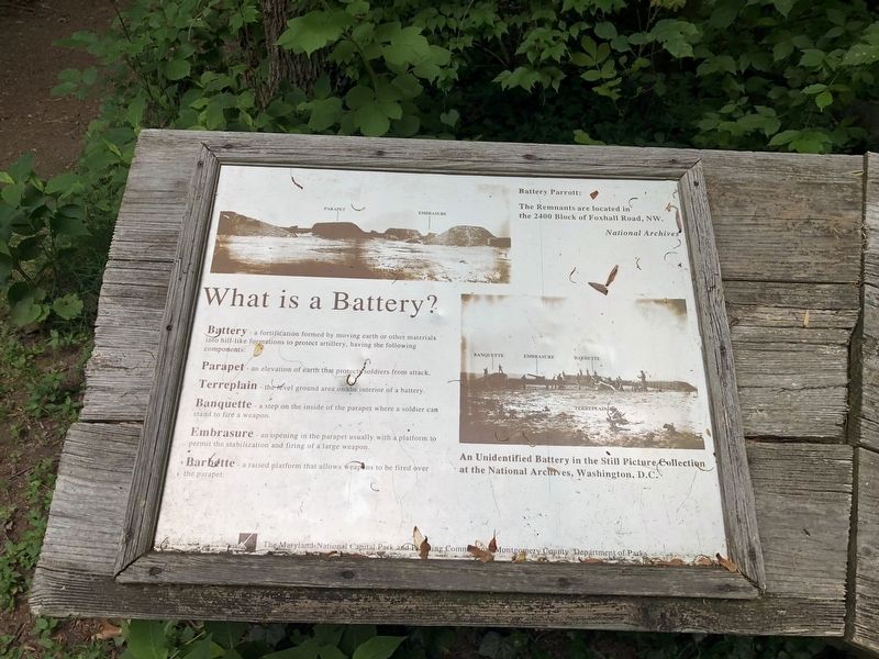
Battery - a fortification formed by moving earth or other materials into hill-like formations to protect artillery, having the following components:
Parapet - an elevation of earth that protects soldiers from attack.
Terreplain - the level ground area on the interior of a battery.
Banquette - a step on the inside of the parapet where a soldier can stand to fire a weapon.
Embrasure - an opening in the parapet usually with a platform to permit the stabilization and firing of a large weapon.
Barbette - a raised platform that allows weapons to be fired over the parapet.
[Captions:]
Battery Parrott: The Remnants are located in the 2400 Block of Foxhall Road, NW. National Archives
An Unidentified Battery in the Still Picture Collection at the National Archives, Washington, D.C.
Erected by The Maryland-National Capital Park and Planning Commission; Montgomery County Department of Parks.
Topics and series. This historical marker is listed in these topic lists: Forts and Castles • War, US Civil. In addition, it is included in the Defenses of Washington series list.
Location. 38° 57.145′ N, 77° 6.603′
Other nearby markers. At least 8 other markers are within walking distance of this marker. Artist's Conception of Battery Bailey, Circa 1862 (here, next to this marker); Defending the City of Washington (here, next to this marker); Col. Guilford Dudley Bailey (within shouting distance of this marker); Battery Bailey (within shouting distance of this marker); Loughborough Mill (approx. half a mile away); a different marker also named Loughborough Mill (approx. half a mile away); Original Federal Boundary Stone, District of Columbia, Northwest 5 (approx. half a mile away); The Dalecarlia Tunnel (approx. 0.7 miles away). Touch for a list and map of all markers in Bethesda.
Credits. This page was last revised on June 4, 2021. It was originally submitted on June 4, 2021, by Richard E. Miller of Oxon Hill, Maryland. This page has been viewed 163 times since then and 14 times this year. Photos: 1, 2. submitted on June 4, 2021, by Devry Becker Jones of Washington, District of Columbia. • Devry Becker Jones was the editor who published this page.

