Near Morgantown in Monongalia County, West Virginia — The American South (Appalachia)
"Clean Mountain Water" Not So Clean
Interpreting History
Reliance on the Monongahela River to supply enough water to a growing Morgantown meant the overall year-round quality remained a subject of great concern. West Virginia University researchers in the 1920s identified the problems with the river water and its causes as lying upstream, but also found lesser issues with the Tibbs Run Reservoir water. They suggested chemical treatments of different types and amounts, depending on the water source.
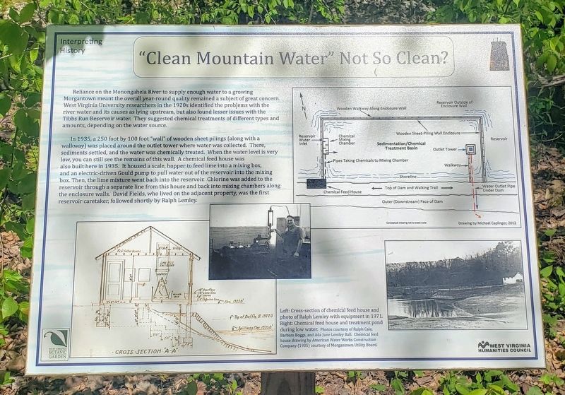
In 1935, a 250 foot by 100 foot "wall” of wooden sheet pilings (along with a walkway) was placed around the outlet tower where water was collected. There, sediments settled, and the water was chemically treated. When the water level is very low, you can still see the remains of this wall. A chemical feed house was also built here in 1935. It housed a scale, hopper to feed lime into a mixing box,band an electric-driven Gould pump to pull water out of the reservoir into the mixing box. Then, the lime mixture went back into the reservoir. Chlorine was added to the reservoir through a separate line from this house and back into mixing chambers along the enclosure walls. David Fields, who lived on the adjacent property, was the first reservoir caretaker, followed shortly by Ralph Lemley.
Erected 2014 by West Virginia Botanic Garden and West Virginia Humanities Council.
Topics. This historical marker is listed in these topic lists: Environment • Natural Resources • Waterways & Vessels. A significant historical year for this entry is 1935.
Location. 39° 37.677′ N, 79° 52.187′ W. Marker is near Morgantown, West Virginia, in Monongalia County. Marker can be reached from Tyrone Road (County Road 75) 0.1 miles south of Quartz Drive, on the right when traveling east. The marker stands on the Reservoir Loop Trail at the West Virginia Botanic Garden. Touch for map. Marker is at or near this postal address: 1061 Tyrone Road, Morgantown WV 26508, United States of America. Touch for directions.
Other nearby markers. At least 8 other markers are within walking distance of this marker. The Tibbs Run Reservoir: Then a Water Source, Now a Local Treasure (within shouting distance of this marker); Remnants of the Past: The Dam and Outlet Tower (approx. 0.2 miles away); Who Wants Clean Water? (approx. 0.2 miles away); Strong Men and Horses Build the Basin (approx. 0.2 miles away); Ralph Lemley: Resourceful Caretaker (approx. 0.2 miles away); Prehistoric Garden (approx. ¼ mile away); A Small Dam and a Big "Bowl" Meet the Need for Clean Water (approx. ¼ mile away); Clean Water Comes To Morgantown (approx. 0.3 miles away). Touch for a list and map of all markers in Morgantown.
Credits. This page was last revised on June 10, 2021. It was originally submitted on June 5, 2021, by Bradley Owen of Morgantown, West Virginia. This page has been viewed 144 times since then and 13 times this year. Photos: 1, 2. submitted on June 5, 2021, by Bradley Owen of Morgantown, West Virginia. • Devry Becker Jones was the editor who published this page.

