Near Groveton in Prince William County, Virginia — The American South (Mid-Atlantic)
Second Battle of Manassas
August 28-30, 1862
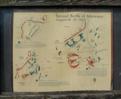
Lee dispatched Stonewall Jackson on a daring raid to cut Pope's communications before Pope could receive massive reinforcements. Marching nearly 25 miles a day, Jackson burned the supply depot at Manassas, then positioned himself behind an unfinished railroad grade to await the arrival of General Lee with Longstreet's wing. Pope moved to crush Jackson.
(2) Second Manassas August 29, 1862
As his units arrived, Pope attacked Jackson. A spirited bayonet charge by Grover momentarily broke through. Kearny and Stevens forced back Jackson's left, but the Confederates tenaciously held. Lee and Longstreet arrived at noon. Diverted by Union movements to the south however, Longstreet did not participate in the fighting, except for Hood's collision with Hatch at dusk.
(3) Second Manassas, August 30, 1862
Dismissing reports of Longstreet's concealed presence, Pope furiously assailed Jackson's front, but was repulsed. Lee seized the opportunity to counterattack with Longstreet's fresh divisions. Warren's brigade was nearly annihilated. Pope, desperate to save his army from ruin, shifted units to confront Longstreet. A dogged stand on Henry Hill ended the battle. Union casualties were about 1700 killed, 8400 wounded, and 4200 missing - 14,300. Lee lost about 1600 killed, 7800 wounded, 100 missing - 9500.
Topics. This historical marker is listed in this topic list: War, US Civil. A significant historical year for this entry is 1862.
Location. This marker has been replaced by another marker nearby. It was located near 38° 48.696′ N, 77° 33.447′ W. Marker was near Groveton, Virginia, in Prince William County. Marker could be reached from Lee Highway (U.S. 29), on the right when traveling west. Located at driving tour stop one, Battery Heights, in Manassas National Battlefield Park. Touch for map. Marker was at or near this postal address: 12048 Lee Hwy, Gainesville VA 20155, United States of America. Touch for directions.
Other nearby markers. At least 8 other markers are within walking distance of this location. Battery Heights (a few steps from this marker); Manassas National Battelfield Park (a few steps from this marker); Broken by Artillery (within shouting distance of this marker); a different marker also named Battery Heights (about 500 feet away, measured in a direct line); Company B, 4th U.S. Artillery (about 600 feet away); 76th New York Infantry (approx. 0.2 miles away); 7th Wisconsin Infantry (approx. ¼ mile away); 6th Wisconsin Infantry (approx. ¼ mile away). Touch for a list and map of all markers in Groveton.
More about this marker. Over each numbered section is a map depicting the operations described in the text.
A new marker titled "Battery Heights" replaced this marker in 2012. See nearby markers.
Credits. This page was last revised on April 9, 2022. It was originally submitted on March 30, 2009, by Craig Swain of Leesburg, Virginia. This page has been viewed 1,182 times since then and 7 times this year. Photos: 1, 2. submitted on March 30, 2009, by Craig Swain of Leesburg, Virginia.

