Swanton Township near Whitehouse in Lucas County, Ohio — The American Midwest (Great Lakes)
The Oak Openings Region
Photographed by Craig Doda, May 26, 2021
1. The Oag Openings Region Marker
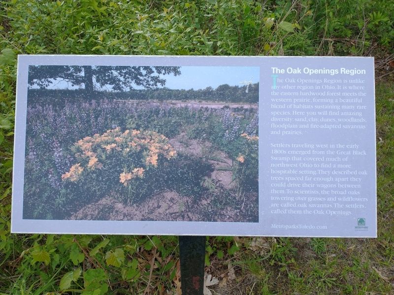
The Oak Openings Region is unlike any other region in Ohio. It is where the eastern hardwood forest meets the western prairie, forming a beautiful blend of habitats sustaining many rare species. Here you will find amazing diversity: sand, clay, dunes, woodlands, floodplain and fire-adapted savannas and prairies.
Settlers traveling west in the early 1800s emerged from the Great Black Swamp that covered much of northwest Ohio to find a more hospitable setting.They described oak trees spaced far enough apart they could drive their wagons between them. To scientists, the broad oaks towering over grasses and wildflowers are called.oak savannas. The settlers called them the Oak Openings.
Topics. This historical marker is listed in these topic lists: Horticulture & Forestry • Natural Features • Settlements & Settlers.
Location. 41° 32.129′ N, 83° 50.366′ W. Marker is near Whitehouse, Ohio, in Lucas County. It is in Swanton Township. It is on Horse Trail 0.2 miles north of Wilkins Road (County Road 108), on the right when traveling north. Touch for map.
this page online

Regionally, this marker is on the Lake Erie Shore and in the Toledo Metropolitan Area. It is also in the American Midwest and in the Corn Belt. Globally, it is in North America, on the Great Lakes, in the Western Hemisphere, in the Western World, and in the Anglosphere. Historically, it finds itself in what was once the Viceroyalty of New France, the Haudenosaunee (Iroquois) Confederacy, the territory of the Mississippian Culture, and the Northwest Territory.
Other nearby markers. At least 8 other markers are within 3 miles of this marker, measured as the crow flies: A Cross Section Of History (approx. 0.6 miles away); Gulf Wars & Afghanistan War (approx. 2.2 miles away); Other Military Operations (approx. 2.2 miles away); Vietnam War (approx. 2.2 miles away); Korean War (approx. 2.2 miles away); World War II (approx. 2.2 miles away); World War I (approx. 2.2 miles away); Whitehouse Veterans Memorial Park (approx. 2.2 miles away). Touch for a list and map of all markers in Whitehouse.
Photographed by Craig Doda, May 26, 2021
2. The Oag Openings Region Marker
Photographed by Craig Doda, May 26, 2021
3. The Oag Openings Region Marker
Credits. This page was last revised on February 6, 2023. It was originally submitted on June 6, 2021, by Craig Doda of Napoleon, Ohio. This page has been viewed 424 times since then and 43 times this year. Photos: 1, 2, 3. submitted on June 6, 2021, by Craig Doda of Napoleon, Ohio. • Devry Becker Jones was the editor who published this page.
