Historical Timbering, Mining, & Agriculture
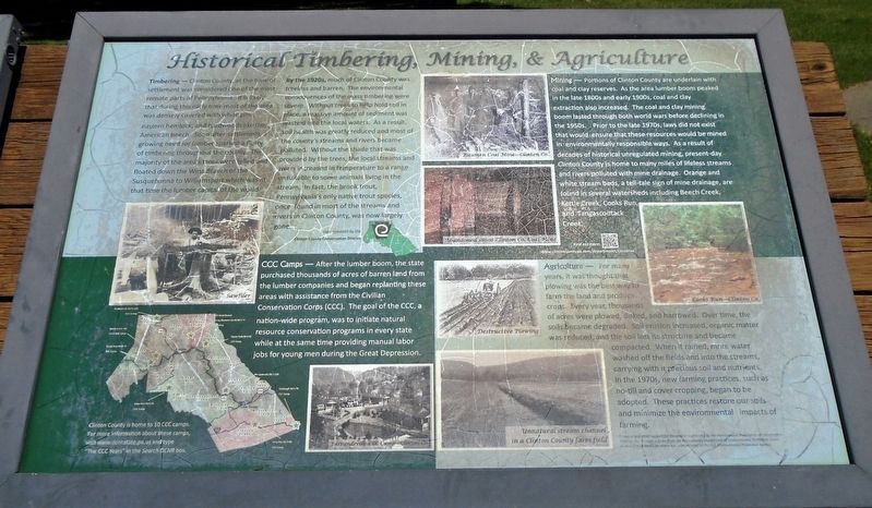
Timbering Clinton County, at one time of settlement was considered one of the most remote parts of Pennsylvania. It is likely that during this early time most of the area was densely covered with white pine, eastern hemlock, and hardwoods like the American beech. Soon after settlement, a growing need for lumber sparked a flurry of timbering throughout the county. The majority of the area's trees were felled and floated down the West Branch of the Susquehanna to Williamsport which was at that time the lumber capital of the world.
By the 1920s, much of Clinton County was treeless and barren. The environmental consequences of the mass timbering were severe. Without trees to help hold soil in place, a massive amount of sediment was washed into the local waters. As a result, soil health was greatly reduced and most of the county's streams and rivers became polluted. Without the shade that was provided by the trees, the local streams and rivers increased in temperature to a range unsuitable to some animals living in the stream. In fact, the brook trout, Pennsylvania's only native trout species, once found in most of the streams and rivers in Clinton County, was now largely gone.
[Photo caption reads] Sawfiler
Mining Portions of Clinton County are underlain with coal and clay reserves.
As the area lumber boom peaked in the late 1800s and early 1900s, coal and clay extraction also increased. The coal and clay mining boom lasted through both world wars before declining in the 1950s. Prior to the late 1970s, laws did not exist that would ensure that these resources would be mined in environmentally responsible ways. As a result of decades of historical unregulated mining, present-day Clinton County is home to many miles of lifeless streams and rivers polluted with mine drainage. Orange and white stream beds, a tell-tale sign of mine drainage, are found in several watersheds including Beech Creek, Kettle Creek, Cooks Run, and Tangascootack Creek.
[Photo captions read]
Bitumen Coal Mine - Clinton Co.
Abandoned 1800s Clinton Co. Coal Mine
Cooks Run - Clinton Co.
Agriculture For many years, it was thought that plowing was the best way to farm the land and produce crops. Every year, thousands of acres were plowed, disked, and harrowed. Over time, the soils became degraded. Soil erosion increased, organic matter was reduced, and the soil lost its structure and became compacted. When it rained, more water washed off the fields and into streams, carrying with it precious soil and nutrients. In the 1970s, new farming practices, such as no-till and cover cropping, began to be adopted. These practices restore our soils and
[Photo captions read]
Destructive Plowing
Unnatural stream channel in a Clinton County farm field
CCC Camps After the lumber boom, the state purchased thousands of acres of barren land from the lumber companies and began replanting these areas with assistance from the Civilian Conservation Corps (CCC). The goal of the CCC, a nation-wide program, was to initiate natural resource conservation programs in every state while at the same time providing manual labor jobs for young men during the Great Depression.
[Photo captions read]
[Map] Clinton County is home to 10 CCC camps. For more information about these camps, visit www.dcnr.state.pa.us and type "The CCC Years" in the Search DCNR box.
Farrandsville CCC Camp - Clinton Co.
Erected by Clinton County Conservation District.
Topics. This historical marker is listed in these topic lists: Environment • Horticulture & Forestry • Industry & Commerce • Waterways & Vessels.
Location. 41° 3.141′ N, 77° 9.532′ W. Marker is near Loganton, Pennsylvania, in Clinton County. Marker is on Interstate 80 at milepost 194, on the right when traveling west
Other nearby markers. At least 8 other markers are within 8 miles of this marker, measured as the crow flies. Discover Elk Scenic Drive (within shouting distance of this marker); World War II Memorial (approx. 6.4 miles away); Middle East Conflicts (approx. 7.8 miles away); James Logan (approx. 7.8 miles away); World War II (approx. 7.8 miles away); Korean War (approx. 7.8 miles away); a different marker also named World War II (approx. 7.8 miles away); Vietnam Conflict (approx. 7.8 miles away). Touch for a list and map of all markers in Loganton.
Also see . . . Clinton County (PA) Conservation District: About Us. (Submitted on June 27, 2021, by William Fischer, Jr. of Scranton, Pennsylvania.)
Additional keywords. Historical Timbering, Mining, & Agriculture
Credits. This page was last revised on June 27, 2021. It was originally submitted on June 27, 2021, by William Fischer, Jr. of Scranton, Pennsylvania. This page has been viewed 127 times since then and 24 times this year. Photos: 1, 2. submitted on June 27, 2021, by William Fischer, Jr. of Scranton, Pennsylvania.

