Why was Fort Randolph Built?
Was there a third fort, Fort Alexandria?
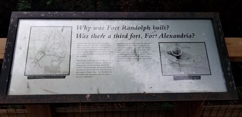
Louisiana had suffered repeated invasions by the Union Army in 1863 and 1864. There were fears that a spring 1865 attack was going to be made. General Edmund Kirby Smith, commander of the Trans-Mississippi Department, saw a need for strong fortifications on the Red River in preparation for this possibility.
After the fall of other forts along the Red River such as Fort DeRussy that had been built on low lying ground, a location on higher ground was needed. Two promontories were found north of Alexandria on the Pineville side of the river, near the remains of Bailey's Dam. Fort Randolph was to be built on the promontory that was closer to the town of Alexandria.
Was there a third fort being built at the same time? A third fort, Fort Alexandria, was planned to be built near Alexandria as part of the river defenses. Captain Randolph, who was put in charge of the fort's construction, had planned on beginning construction in December 1864. However, there is
no evidence that a fort was built there, although an earthwork fort with six artillery pieces was found further downstream.
Topics. This historical marker is listed in these topic lists: Forts and Castles • War, US Civil.
Location. 31° 19.458′ N, 92° 26.879′ W. Marker
Other nearby markers. At least 8 other markers are within walking distance of this marker. How was Fort Randolph Built? (here, next to this marker); Desertion and the end of the War (within shouting distance of this marker); Who was Stationed at Fort Randolph (about 300 feet away, measured in a direct line); Welcome to Fort Buhlow (approx. ¼ mile away); Deserting soldiers and the end of the war (approx. ¼ mile away); Who was Fort Buhlow named after? (approx. ¼ mile away); Why Was Fort Buhlow Built? (approx. ¼ mile away); How Fort Buhlow was built (approx. ¼ mile away). Touch for a list and map of all markers in Pineville.
Credits. This page was last revised on July 16, 2021. It was originally submitted on July 3, 2021, by Cajun Scrambler of Assumption, Louisiana. This page has been viewed 97 times since then and 7 times this year. Photos: 1, 2. submitted on July 5, 2021, by Cajun Scrambler of Assumption, Louisiana.

