Fort Hunter in Montgomery County, New York — The American Northeast (Mid-Atlantic)
Canal Dams
Schoharie Crossing
— State Historic Site —
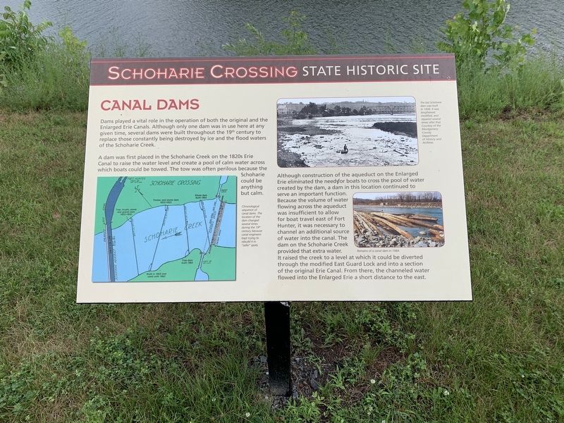
Dams played a vital role in the operation of both the original and the Enlarged Erie Canals. Although only one dam was in use here at any given time, several dams were built throughout the 19th century to replace those constantly being destroyed by ice and the flood waters of the Schoharie Creek.
A dam was first placed in the Schoharie Creek on the 1820s Erie Canal to raise the water level and create a pool of calm water across which boats could be towed. The tow was often perilous because the Schoharie could be anything but calm.
Although construction of the aqueduct on the Enlarged Erie eliminated the need for boats to cross the pool of wáter created by the dam, a dam in this location continued to serve an important function. Because the volume of flowing across the aqueduct was insufficient to allow for boat travel east of Fort Hunter, it was necessary to channel an additional source of water into the canal. The dam on the Schoharie Creek provided that extra water. It raised the creek to a level at which it could be diverted through the modified East Guard Lock and into a section of the original Erie Canal. From there, the channeled water flowed into the Enlarged Erie a short distance to the east.
(Lower Left:) Chronological sequence of canal dams. The location of the dam changed several times during the 19th because canal engineers kept trying to rebuild it in “safer” spots.
(Center:) Remains of a canal dam in 1984.
(Upper Right:) The last Schoharie dam was built in 1894. It was lengthened, modified, and repaired several times after that. Courtesy of the Montgomery County Department of History and Archives.
Topics. This historical marker is listed in this topic list: Waterways & Vessels. A significant historical year for this entry is 1984.
Location. 42° 56.366′ N, 74° 16.952′ W. Marker is in Fort Hunter, New York, in Montgomery County. Marker is on Schoharie Street south of Main Street (County Route 27), on the left when traveling south. Touch for map. Marker is in this post office area: Fort Hunter NY 12069, United States of America. Touch for directions.
Other nearby markers. At least 8 other markers are within walking distance of this marker. In the Wake of Hurricane Irene (a few steps from this marker); Once A Farm (within shouting distance of this marker); The Fort by the Village (within shouting distance of this marker); Building Block of the Erie Canal (within shouting distance of this marker); Site of Queen Anne Chapel (within shouting distance of this marker); Site of First Bridge (within shouting distance of this marker); Original Erie Canal (within shouting distance of this marker); Site of Last Mohawk Indian Village (within shouting distance of this marker). Touch for a list and map of all markers in Fort Hunter.
Credits. This page was last revised on July 8, 2021. It was originally submitted on July 6, 2021, by Steve Stoessel of Niskayuna, New York. This page has been viewed 133 times since then and 14 times this year. Photos: 1, 2. submitted on July 6, 2021, by Steve Stoessel of Niskayuna, New York. • Michael Herrick was the editor who published this page.

