Newport in Lincoln County, Oregon — The American West (Northwest)
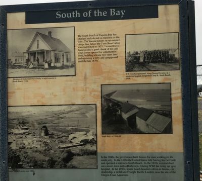
South of the Bay
In the 1880s, the government built houses for men working on the south jetty. In the 1890s the United States Life Saving Service built and operated a station in South Beach. In the 1910s investors laid out a resort town called Harborton. During WWI the Army set up a hospital. In the 1950s, South Beach boasted a drive-in theater, car dealership, a motel and Triangle Pacific Lumber, now the site of the Oregon Coast Aquarium.
Captions (clockwise from top right)
• WWI medical personnel, Army Spruce Division, at a temporary hospital, designated Camp B., South Beach, 1918.
• South Jetty, ca. 1886-89.
• Triangle Pacific Lumber, mid-1950s.
• Members of the Lemuel Davis family at their homesite in South Beach, 1910s.
Erected by Port of Newport.
Topics. This historical marker is listed in these topic lists: Industry & Commerce • Native Americans • Science & Medicine • Settlements & Settlers. A significant historical year for this entry is 1855.
Location. 44° 37.184′ N, 124° 3.193′ W. Marker is in Newport, Oregon, in Lincoln County. Marker can be reached from Southeast Marine Science Drive, on the right when traveling west. Marker is beneath south end of the Yaquina Bay Bridge near the Newport Municipal Crabbing Pier. Touch for map. Marker is at or near this postal address: 2320 SE Marine Science Drive, Newport OR 97365, United States of America. Touch for directions.
Other nearby markers. At least 8 other markers are within walking distance of this marker. Protecting the Coast (here, next to this marker); Reeling Them In (here, next to this marker); Shipping News (here, next to this marker); Bridging the Waters (a few steps from this marker); Bayfront Beginnings (a few steps from this marker); United States Coast Guard Motor Lifeboat CG 36503 (approx. half a mile away); Yaquina Bay Bridge (approx. half a mile away); Yaquina Bay Light (approx. half a mile away). Touch for a list and map of all markers in Newport.
Credits. This page was last revised on July 11, 2021. It was originally submitted on July 11, 2021, by Duane and Tracy Marsteller of Murfreesboro, Tennessee. This page has been viewed 152 times since then and 15 times this year. Photos: 1, 2. submitted on July 11, 2021, by Duane and Tracy Marsteller of Murfreesboro, Tennessee.

