Walker’s Best
⎯⎯⎯
Grinding Away
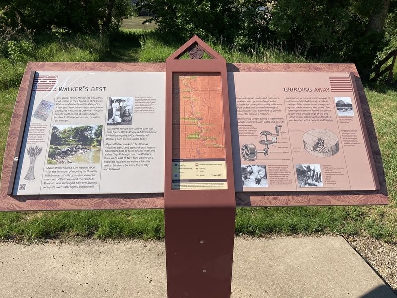
Myron Walker built a dam here in 1906 with the intention of moving his Oakville Mill from a half mile upstream, closer to the town of Kathryn—and the railroad. The dam was sabotaged, however, during a dispute over water rights, and the mill was never moved. The current dam was built by the Works Progress Administration (WPA) during the 1930s. Remains of Walker's dam are still visible today.
Myron Walker marketed his flour as "Walker's Best," and teams of draft horses hauled product to railheads at Fingal and Valley City. Although much of Walker's flour went east to New York City, he also supplied local towns within a 40-mile radius: Eckelson, Enderlin, Tower City, and Griswold.
this page online
The flowing stream turned a waterwheel, which was linked with shafts and gears to turn the top, or "runner stone" in a pair of millstones. Grain, fed through a hole in the top of the runner stone, was ground against the bottom, or "bed stone." The rotating runner stone forced the ground grain to the outside edge of the bed stone where, dropping into a trough, it was brushed into a hopper and bagged.
Captions:
Small towns often "sprang-
up in the vicinity of flour
mills, and their fate was
often determined by a
mill's success. The once
prosperous nearby towns
of Daily and Oakville, for
example, have all but
vanished in the wake of
the location of the railroad
further south.
Grinding grain for the area's
farmers was a large part of Myron
Walker's mill trade. Farmers came
from miles around to have their
harvest ground into
flour. Trips to
the mill provided a much-
anticipated holiday for farm
families a chance to fish and
swim in the Sheyenne River, to
pick berries, shop, and socialize!
Basic mill operations A system of water wheels
shafts, gears, belts, and pulleys
operate a mill. These elements
were often housed in several
buildings and connected
underground or through walls.
The Walker Mill at Valley
City, circa 1880. It was
replaced by a larger mi
building in 1902.
Millstones are traditionally
made from segments of a
very hard rock, such as
granite. The segments are
sculpted to form a circle
and are bound together
with an iron band. This
mill's original stones are
believed to have come from
Normandy, France.
A pair of millstones working ten-
hour days required "re-dressing"
about once each month. The
constant grating of the stones
against each other wore down and
flattened their grooved grinding
surfaces. Re-dressing was the
difficult task of renewing the
grooves with chisel-like tools called
bills and picks. Millstones, working
full time, could last 20 to 25 years.
Dressing tools:
1. Sledge hammer
2. Wedge for supporting upturned
runner stone
3. Wooden handle that holds
interchangeable bills and picks
4. Mill pick
5. Mill bill
6. Chisel
7. Hand hammer
8. Sharpening file
Erected by Federal
Topics. This historical marker is listed in these topic lists: Industry & Commerce • Settlements & Settlers • Waterways & Vessels. A significant historical year for this entry is 1879.
Location. 46° 40.432′ N, 97° 56.693′ W. Marker is near Kathryn, North Dakota, in Barnes County. It is on 51st Street Southeast (County Road 21) near 120th Avenue Southeast, on the left when traveling east. Touch for map. Marker is in this post office area: Kathryn ND 58049, United States of America. Touch for directions.

Regionally, this marker is in the Red River Valley. It is also in the American Lewis & Clark Corridor, on the prairies, and on the Northern Plains. Globally, it is in North America, the Western Hemisphere, the Western World, and the Anglosphere. Historically, it finds itself in what was once Rupert’s Land and also the Louisiana Purchase.
Other nearby markers. At least 8 other markers are within 4 miles of this marker, measured as the crow flies: A Tribute to Pioneer Living / Building a Hand-Hewn Cabin (within shouting distance of this marker); Wadeson Cabin Historic Site (within shouting distance of this marker); Waldheim Church / Ladies Aid Societies (approx. 0.7 miles away); Kathryn / Sentinels of the Prairie (approx. 1.2 miles away); The Great American Barn / Rural Architecture (approx. 3.4 miles away); Site of Daily School No. 1 / Site of Daily Dak. Ter. (approx. 3.4 miles away); Standing Rock / Wonderful Wetlands (approx. 3.9 miles away); Standing Rock Hill Historic Site (approx. 3.9 miles away). Touch for a list and map of all markers in Kathryn.
Credits. This page was last revised on July 14, 2021. It was originally submitted on July 12, 2021, by Connor Olson of Menomonee Falls, Wisconsin. This page has been viewed 435 times since then and 27 times this year. Last updated on July 12, 2021, by Connor Olson of Menomonee Falls, Wisconsin. Photos: 1, 2. submitted on July 12, 2021, by Connor Olson of Menomonee Falls, Wisconsin. • Mark Hilton was the editor who published this page.
