Orwell in Addison County, Vermont — The American Northeast (New England)
Burial Site
Mount Independence State Historic Site
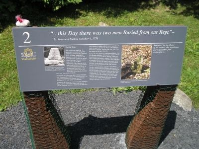
“ . . . this Day there was two men Buried from our Regt.”
- Lt. Jonathan Burton, October 4, 1776
This small stone, engraved “N. Richardson of Staddard Eng died 1760,” may mark the only identified grave on Mount Independence. Research has yet to discover who Richardson was or solve the mystery of the 1760 date. This was sixteen years before the Northern Department of the American Army began building Mount Independence as a defense against the British in the American Revolution. Is it a gravestone from the French and Indian War? Over time the elements have worn away the inscription.
The number of soldiers who died at Mount Independence is known only to history, but at least dozens if not many more lost their lives between July 1776 and November 1777, to be buried far from home.
Located on the Mount are several unmarked cemeteries. These soldiers – American, British, and Germans, as well as Canadians and Native Americans on both sides – were victims of disease suffered here or casualties of battle, brought back from the July 7, 1777, battles at Hubbardton, Vermont, and Fort Ann, New York. They died while serving their countries.
During the early months of American occupation, from July through September 1776, the first to die at Mount Independence received military funerals. Fellow soldiers wrapped the bodies in blankets. They auctioned off personal effects, which would have been difficult to return home, and sent the money to the family of the deceased. As the number of deaths increased, burials became rushed and haphazard with little formality.
The Rev. Ammi Robbins, chaplain of Col. Charles Burrall’s Connecticut State Regiment that was part of the First Brigade, wrote in his journal of witnessing the military funeral of a regimental soldier on the evening of September 8, 1776. “There is something more than ordinary solemn and touching in our funerals, especially an officer’s: swords and arms inverted, others with their arms folded across their breast stepping slowly to the beat of the muffled drum.”
Remember the sacrifices of the soldiers who served here and respect their final resting places.
Erected by Mount Independence State Historic Site.
Topics. This historical marker is listed in these topic lists: Cemeteries & Burial Sites • War, US Revolutionary. A significant historical date for this entry is July 12, 1776.
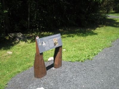
Location. 43° 49.568′ N, 73° 22.973′ W. Marker is in Orwell, Vermont, in Addison County. Marker can be reached from Mount Independence Road, on the right when traveling south. Marker is along a walking trail in Mount Independence State Historic Site. Touch for map. Marker is in this post office area: Orwell VT 05760, United States of America. Touch for directions.
Other nearby markers. At least 8 other markers are within walking distance of this marker. To Repel the Enemy (about 500 feet away, measured in a direct line); Officers Quarters – 1776 (about 500 feet away); General Hospital – 1777 (about 700 feet away); Heritage Travelers over the Years (approx. 0.2 miles away); Third Brigade Encampment – 1776 (approx. 0.2 miles away); Storehouse - 1776 (approx. ¼ mile away); Fort Ticonderoga and Mount Defiance (approx. ¼ mile away); Lake Champlain and the American Revolution (approx. ¼ mile away). Touch for a list and map of all markers in Orwell.
More about this marker. The left side of the marker contains a photograph of the nearby gravestone. It has a caption of “N. Richardson gravestone in front of you as it looked in 1985. Collection of the Vermont Division for Historic Preservation.” The right of the marker features a photograph of “Possibly the headstone and footstone of a Revolutionary War grave on Mount Independence.”
Related markers. Click here for a list of markers that are related to this marker. This series of markers are found on the walking trails in Mount Independence State Historic Site.
Credits. This page was last revised on November 3, 2020. It was originally submitted on April 11, 2009, by Bill Coughlin of Woodland Park, New Jersey. This page has been viewed 2,010 times since then and 21 times this year. Photos: 1, 2, 3. submitted on April 11, 2009, by Bill Coughlin of Woodland Park, New Jersey.


