Mukilteo in Snohomish County, Washington — The American West (Northwest)
Geology of Mukilteo
Mulkilteo Walking Tour Stop 7
Geology
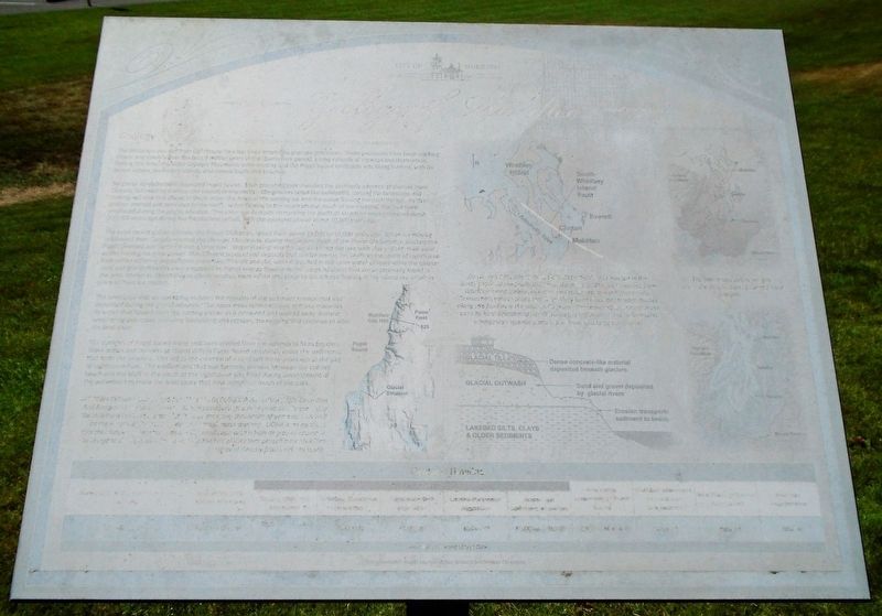
The landscape you see from Lighthouse Park has been shaped by geologic processes. These processes have been working slowly and steadily over the past 2 million years of the Quaternany period, a long episode of creation and destruction. During this time, the older Olympic Mountains were eroding and the Puget Sound landscape was being formed, with its broad waters, distinctive islands, and coastal bluffs and beaches.
Six glacial episodes have impacted Puget Sound. Each glacial episode included the southerly advance of glaciers from Canada, followed by melting and retreat to the north. The glaciers acted like bulldozers, carving the landscape and moving soil and rock ahead of them under the force of the moving ice and the water flowing beneath the ice. As the glaciers melted and retreated to the north, water flowing to the south eroded much of the material that had been emplaced during the glacial advance. The older soil deposits comprising the bluffs of Mukilteo were emplaced about 200,000 years ago during the Pleistocene period, with the youngest placed about 10,000 years ago.
The most recent glacial episode, the Fraser Glaciation, lasted from about 25,000 to 10,000 years ago. When ice moving southward from Canada reached the Olympic Mountains, during the Vashon Stage of the Fraser Glaciation, it blocked the Puget Lowland and turned it into a large lake. Water flowing into the lowland filled the lake with clay and silt, then sand as the moving ice grew closer. The different types of soil deposits that can be seen in the bluffs to the south of Lighthouse Park reflect differing processes. The silt and clay were deposited in the quiet water of lakes while the coarser sand and gravel deposits were emplaced by higher energy flowing water. Large boulders that are occasionally found in the area, known as dropstones or glacial erratics, were rafted into place by ice masses floating in the inland sea or left in place as fixed ice melted.
The landscape that we see today includes the remains of the sediment transported and deposited during the glacial advance. The open areas reflect erosion of these materials by water that flowed from the melting glaciers as it retreated and wasted away. Natural weathering processes, including landsliding and erosion, are ongoing and continue to alter the landscape.
The currents of Puget Sound move sediment eroded from the uplands to form beaches. Wave action and currents or littoral drift in Puget Sound constantly move the sediments that form the beaches. This led to the creation of a sand spit many years ago at the site of Lighthouse Park. The embayment that was formerly present between the current beach and the bluff to the
south of the Lighthouse was filled during development of the waterfront to make the level space that now comprises much of the park.
MODERN TECHNOLOGY HELPS REVEAL OUR GEOLOGIC PAST.
[paragraph, timeline at bottom of marker, and map captions are illegible]
Erected by City of Mukilteo.
Topics. This historical marker is listed in this topic list: Environment.
Location. 47° 56.895′ N, 122° 18.369′ W. Marker is in Mukilteo, Washington, in Snohomish County. Marker is on Front Street, on the right when traveling around the traffic circle. Marker is at Mukilteo Lighthouse Park, south of the lighthouse. Touch for map. Marker is at or near this postal address: 609 Front Street, Mukilteo WA 98275, United States of America. Touch for directions.
Other nearby markers. At least 8 other markers are within walking distance of this marker. Early Explorers (here, next to this marker); Light Station and Park (within shouting distance of this marker); Commemorating Signing Point Elliott Treaty (within shouting distance of this marker); Native Americans (within shouting distance of this marker); Point Elliott Treaty (within shouting distance of this marker); Tradition of Carving (within shouting distance of this marker); Assistant Keeper's House (within shouting distance of this marker); Landing Site of Capt. George Vancouver (within shouting distance of this marker). Touch for a list and map of all markers in Mukilteo.
More about this marker. The marker is heavily degraded and needs replacement.
Also see . . . PRELIMINARY SURFICIAL GEOLOGIC MAP OF THE. MUKILTEO AND EVERETT QUADRANGLES (WA Dept of Nat Res). (Submitted on August 5, 2021, by William Fischer, Jr. of Scranton, Pennsylvania.)
Credits. This page was last revised on August 5, 2021. It was originally submitted on August 5, 2021, by William Fischer, Jr. of Scranton, Pennsylvania. This page has been viewed 185 times since then and 16 times this year. Photos: 1, 2. submitted on August 5, 2021, by William Fischer, Jr. of Scranton, Pennsylvania.

