Near Ouray in Ouray County, Colorado — The American Mountains (Southwest)
Mine Reclamation Improves Water Quality

Photographed by James Hulse, July 9, 2021
1. Mine Reclamation Improves Water Quality Marker - Panel 1
Panel 1
This region was founded by gold and silver miners in the 1870s. This 17-square mile area has produced 4 million ounces of gold, 21 million ounces of silver, and 12 million tons of lead, zinc and copper. The natural resources from areas like this fueled the industrial revolution and supplied the raw materials to support America's involvement in two world wars.
The Idarado Mining Company, a subsidiary of Newmont Gold Company, began remediation work here in the mid 1980s to improve water quality and aquatic habitat in the region. The project is pioneering source control remediation while preserving the area's historic character.
Panel 2
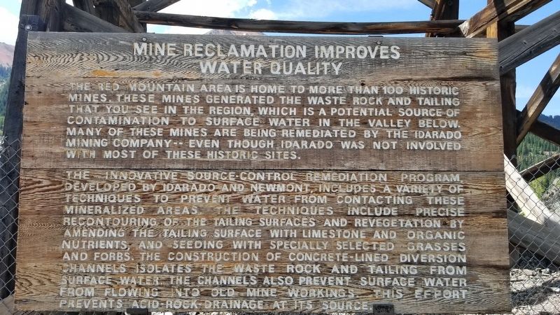
The Red Mountain area is home to more than 100 historic mines these mines generated the waste rock and tailing that you see in the region which is a potential source of contamination to surface water in the valley below. Many of these mines are being remediated by the Idarado Mining Company even though Idarado was not involved with most of these historic sites.
The innovative source-control remediation program developed by Idarado and Newmont, includes a variety of techniques
this page online
Panel 3
A Major Mining Environmental Restoration Project is Ahead
As you travel along the next two miles of the San Miguel Valley, you can see the Idarado Mine Remediation Project pioneering new revegetation techniques and setting a national precedent for environmental remediation. The process includes precise recontouring of the tailing surface, amendment of the tailing surface with limestone and organic nutrients, and seeding with specially selected grasses and forbs το create an engineered vegetative cover.
This project, funded entirely by the Idarado Mining Company, a subsidiary of Newmont Gold Company, represents
Photographed by James Hulse, July 9, 2021
2. Mine Reclamation Improves Water Quality Marker - Panel 2
Erected by Ouray County Historical Society.
Topics. This historical marker is listed in this topic list: Environment.
Location. 37° 54.908′ N, 107° 42.023′ W. Marker is near Ouray, Colorado, in Ouray County. It is on Million Dollar Highway (U.S. 550) 2 miles south of County Highway 30, on the right when traveling north. The marker is located next to the Idarado Mine Trestle. Touch for map. Marker is in this post office area: Ouray CO 81427, United States of America. Touch for directions.

Regionally, this marker is in the Western Slope. It is also in the American Mountain West. Globally, it is in North America, the Rocky Mountains, the Western Hemisphere, the Western World, and the Anglosphere.
Other nearby markers. At least 8 other markers are within walking distance of this marker: The Treasury Tunnel (a few steps from this marker); The Yankee Girl (within shouting distance of this marker); Boom Towns (within

Photographed by James Hulse, July 9, 2021
3. A Major Mining Environmental Restoration Project is Ahead marker - Panel 3

Photographed by James Hulse, July 9, 2021
4. The Mine Reclamation Improves Water Quality Markers are at the end of the line

Photographed by James Hulse, July 9, 2021
5. The view of the Mine Reclamation Improves Water Quality Markers from the road
Credits. This page was last revised on August 8, 2021. It was originally submitted on August 8, 2021, by James Hulse of Medina, Texas. This page has been viewed 311 times since then and 18 times this year. Photos: 1, 2, 3, 4, 5. submitted on August 8, 2021, by James Hulse of Medina, Texas.
