Coupeville in Island County, Washington — The American West (Northwest)
Water Highways

Photographed by William Fischer, Jr., August 1, 2021
1. Water Highways Marker
The Coupeville Wharf was built in 1905 in response to the increased economic, military and social activities in the area, and was one of several that supported the busy shipping commerce to and from Whidbey Island.
In the late 1800s, sailing ships transported cargo such as produce, grains, lumber, livestock and other household goods needed to sustain life and business necessary on the island. The sailing ships gave way to small steamships nicknamed the "Mosquito Fleet" in the early 1900s. Steamship delivery of cargo, mail and passengers was a popular community gathering event at the wharf.
Vessels of the Mosquito Fleet - the Fairhaven, Calista, Camano, Whidby and Atalanta - served Puget Sound transporting goods and passengers to Whidbey Island communities.
The last of the steamships sailed from the wharf in the 1930s. A new era of automobile-based access to the mainland soon followed, as the Mosquito Fleet evolved into a ferry system, and the island became linked to the mainland by the Deception Pass Bridge, which opened in 1935.
[Photo captions, clockwise from top left, read]
• Perry Grove photo of five-masted
this page online
• Fairhaven passenger & freight steamer.
• Whidby steamship arriving with goods on foredeck.
• Townspeople watching the Penn Cove Water Festival from Front Street dock, 1935.
• Passengers disembarking from Mosquito Fleet steamship (possibly the Calista) on the Coupeville Wharf, early 1900s.
Erected by National Park Service, Island County, and Town of Coupeville.
Topics. This historical marker is listed in these topic lists: Industry & Commerce • Waterways & Vessels. A significant historical year for this entry is 1905.
Location. 48° 13.272′ N, 122° 41.324′ W. Marker is in Coupeville, Washington, in Island County. It is at the intersection of NW Alexander Street and Front Street NW, on the right when traveling south on NW Alexander Street. Marker is at the Island County Historical Museum. Touch for map. Marker is at or near this postal address: 908 NW Alexander Street, Coupeville WA 98239, United States of America. Touch for directions.

Regionally, this marker is in the Puget Sound Region and in Greater Seattle. It is also on the American Pacific Coast, in the Pacific

Photographed by William Fischer, Jr., August 1, 2021
2. Water Highways Marker
Other nearby markers. At least 8 other markers are within walking distance of this marker: A Canoe Crossroads (here, next to this marker); In Home Port After Eight Decades (a few steps from this marker); Cross Built for Father Blanchet's Visit (within shouting distance of this marker); Ebey's Landing National Historical Reserve (within shouting distance of this marker); Explore the Reserve (within shouting distance of this marker); Keeping the Alexander Blockhouse alive!!! (within shouting distance of this marker); Welcome (within shouting distance of this marker); Original Home of Seattle’s Best Coffee (within shouting distance of this marker). Touch for a list and map of all markers in Coupeville.
Also see . . . Ebey's Landing National Historical Reserve. National Park Service website entry (Submitted on August 11, 2021, by William Fischer, Jr. of Reynoldsburg, Ohio.)
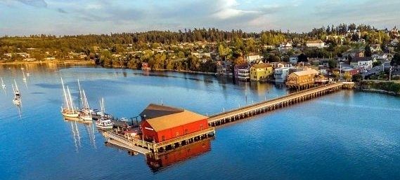
via Town of Coupeville, unknown
3. Town of Coupeville
Town website homepage
Click for more information.
Click for more information.
Credits. This page was last revised on August 26, 2021. It was originally submitted on August 11, 2021, by William Fischer, Jr. of Reynoldsburg, Ohio. This page has been viewed 242 times since then and 16 times this year. Photos: 1, 2. submitted on August 11, 2021, by William Fischer, Jr. of Reynoldsburg, Ohio. 3. submitted on August 26, 2021, by Larry Gertner of New York, New York.
