Vermillion in Clay County, South Dakota — The American Midwest (Upper Plains)
Old Vermillion
August 8, 2021
1. Old Vermillion Marker on Canby St
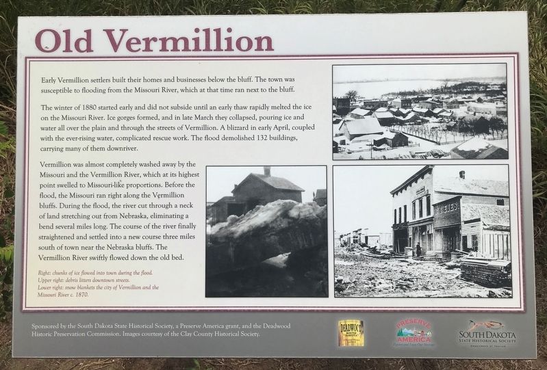
The winter of 1880 started early and did not subside until an early thaw rapidly melted the ice on the Missouri River. Ice gorges formed, and in late March they collapsed, pouring ice and water all over the plain and through the streets of Vermillion. A blizzard in early April, coupled with the ever-rising water, complicated rescue work. The flood demolished 132 buildings, carrying many of them downriver.
Vermillion was almost completely washed away by the Missouri and the Vermillion River, which at its highest point swelled to Missouri-like proportions. Before the flood, the Missouri ran right along the Vermillion bluffs. During the flood, the river cut through a neck of land stretching out from Nebraska, eliminating a bend several miles long. The course of the river finally straightened and settled into a new course three miles south of town near the Nebraska bluffs. The Vermillion River swiftly flowed down the old bed.
Caption:
Right: chunks of ice flowed into town during the flood.
Upper right: debris litters downtown streets.
Lower right: snow blankets the city of Vermillion and the Missouri River c. 1870.
Erected by the
this page online
Topics. This historical marker is listed in these topic lists: Disasters • Settlements & Settlers • Waterways & Vessels. A significant historical year for this entry is 1880.
Location. 42° 46.461′ N, 96° 55.657′ W. Marker is in Vermillion, South Dakota, in Clay County. It is on Canby Street 1.3 miles south of State Route 50, on the left when traveling west. Touch for map. Marker is at or near this postal address: 303 Canby St, Vermillion SD 57069, United States of America. Touch for directions.

Regionally, this marker is in East River. It is also in the American Lewis & Clark Corridor, on the prairies, and on the Northern Plains. Globally, it is in North America, the Western Hemisphere, the Western World, and the Anglosphere. Historically, it finds itself in what was once Rupert’s Land and also the Louisiana Purchase.
Other nearby markers. At least 8 other markers are within walking distance of this marker: Welcome to Cotton Park (approx. 0.2 miles away); Site of the First Permanent School House in Dakota Territory
August 8, 2021
2. Old Vermillion Marker
August 8, 2021
3. Old Vermillion Marker
Credits. This page was last revised on August 14, 2021. It was originally submitted on August 11, 2021. This page has been viewed 618 times since then and 40 times this year. Photos: 1, 2, 3. submitted on August 11, 2021. • Mark Hilton was the editor who published this page.
