Port Townsend in Jefferson County, Washington — The American West (Northwest)
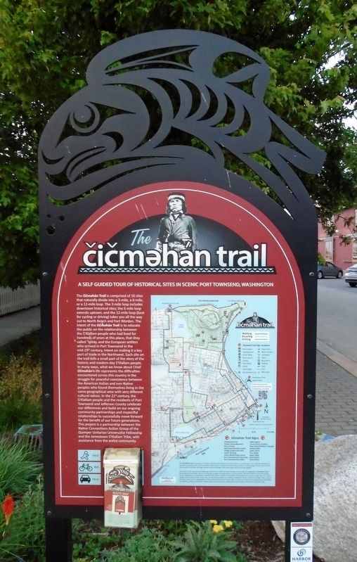
The čičməhán Trail
A Self Guided Tour of Historical Sites in Scenic Port Townsend, Washington
The čičməhán Trail is comprised of 16 sites that naturally divide into a 3-mile, a 6-mile, or a 12-mile loop. The 3-mile loop includes downtown historical sites; the 6 mile loop extends uptown; and the 12-mile loop (best for cycling or driving) takes you all the way out to North Beach and Fort Worden. The intent of the čičməhán Trail is to educate the public on the relationship between the S'Klallam people who had lived for hundreds of years at this place, that they called "qatáy," and the European settlers who arrived in Port Townsend in the mid-19th century, intent on making it a key port of trade in the Northwest. Each site on the trail tells a small part of the story of the historic and modern-day S'Klallam people. In many ways, what we know about Chief čičməhán's life represents the difficulties encountered across this country in the struggle for peaceful coexistence between the American Indian and non-Native peoples who found themselves living in the same geographical area with very different cultural values. In the 21st century, the S'Klallam people and the residents of Port Townsend and Jefferson County celebrate our differences and build on our ongoing community partnerships and respectful relationships to successfully move forward for the benefit of our future generations. This project is a partnership between the Native Connections Action Group of the Quimper Unitarian Universalist Fellowship and the Jamestown S'Klallam Tribe, with assistance from the entire community.
Erected 2019 by Native Connections Action Group of the Quimper Unitarian Universalist Fellowship, the Jamestown S'Klallam Tribe, and Others.
Topics and series. This historical marker is listed in these topic lists: Native Americans • Settlements & Settlers. In addition, it is included in the The Čičməhán Trail, Port Townsend, Washington series list.
Location. 48° 6.973′ N, 122° 45.141′ W. Marker is in Port Townsend, Washington, in Jefferson County. Marker is at the intersection of Water Street and Monroe Street, on the left when traveling east on Water Street. Touch for map. Marker is at or near this postal address: 431 Water Street, Port Townsend WA 98368, United States of America. Touch for directions.
Other nearby markers. At least 8 other markers are within walking distance of this marker. The Welcome Totem Pole (a few steps from this marker); Honoring Eleanor Stopps (a few steps from this marker); Capt. George Vancouver (within shouting distance of this marker); The S'Klallams, The Strong People (within shouting distance of this marker); Canoes Were Made Of Locally Available Materials (within shouting distance of this marker); The Unique Coast Salish Design (within shouting distance of this marker); Intertribal Trade (within shouting distance of this marker); Trade With Newcomers (within shouting distance of this marker). Touch for a list and map of all markers in Port Townsend.
Regarding The čičməhán Trail. The marker is an overview of the purpose of the marker trail and the other markers included on the trail.
Also see . . .
1. The čičməhan trail. (Submitted on August 13, 2021, by William Fischer, Jr. of Scranton, Pennsylvania.)
2. The čičməhán Trail on YouTube. (Submitted on August 16, 2021, by William Fischer, Jr. of Scranton, Pennsylvania.)
Additional keywords. The čičməhán Trail
Credits. This page was last revised on August 18, 2023. It was originally submitted on August 13, 2021, by William Fischer, Jr. of Scranton, Pennsylvania. This page has been viewed 254 times since then and 43 times this year. Photo 1. submitted on August 13, 2021, by William Fischer, Jr. of Scranton, Pennsylvania.
Editor’s want-list for this marker. A distance photo of the marker and surroundings • Can you help?
