
Sanford in Seminole County, Florida — The American South (South Atlantic)
Sanford & Tucker
Sanford Est. 1877
| — | Pathways to History | — |
Photographed by Brandon D Cross, August 7, 2021
1. Sanford & Tucker Marker
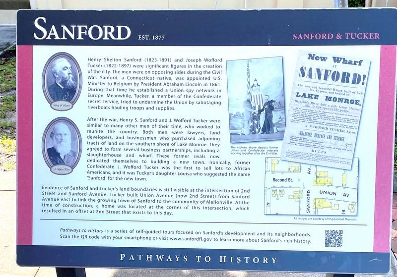
After the war, Henry S. Sanford and J. Wofford Tucker were similar to many other men of their time , who worked to reunite the country. Both men were lawyers, land developers, and businessmen who purchased adjoining tracts of land on the southern shore of Lake Monroe. They agreed to form several business partnerships, including a slaughterhouse and a wharf. These former rivals now dedicated themselves to building a new town. Ironically, former Confederate J. Wofford Tucker was the first to sell lots to African Americans, and it was Tucker’s daughter Louisa who suggested the name “Sanford” for the new town.
Evidence of Sanford
this page online
(caption)
The tableau above depicts former Union and Confederate veterans working together after the Civil War.
Pathways to History is a series of self-guided tours focused on Sanford’s development and its neighborhoods. Scan the QR code with your smartphone or visit www.sanford.gov to learn more about Sanford’s rich history.
All images are courtesy of the Sanford Museum.
Erected by City of Sanford.
Topics. This historical marker is listed in these topic lists: Industry & Commerce • Settlements & Settlers • War, US Civil. A significant historical year for this entry is 1877.
Location. 28° 48.656′ N, 81° 15.896′ W. Marker is in Sanford, Florida, in Seminole County. It is at the intersection of Sanford Avenue and East Second Street,
Photographed by Brandon D Cross, August 7, 2021
2. Sanford & Tucker Marker

Regionally, this marker is in Greater Orlando and in Central Florida. It is also in the American South. Globally, it is in the North Atlantic Region, North America, a Gulf of Mexico state, the Western Hemisphere, the Western World, and the Anglosphere. Historically, it finds itself in what was once New Spain, the territory of the Mississippian Culture, one of the Confederate States of America, and the Antebellum South.
Other nearby markers. At least 8 other markers are within walking distance of this marker: Sanford Est. 1877 (within shouting distance of this marker); Early City Development (within shouting distance of this marker); Georgetown (about 300 feet away, measured in a direct line); The E. E. Brady Livery Stable (about 300 feet away); The Bishop Block (about 300 feet away); The Whalers Saloon (about 400 feet away); Vanished Sanford (about 400 feet away); The U.S. Post Office (about 500 feet away). Touch for a list and map of all markers in Sanford.
Also see . . . Sanford: a Brief History. (Submitted on August 14, 2021, by Brandon D Cross of Flagler Beach, Florida.)
Credits. This page was last revised on August 14, 2021. It was originally submitted on August 14, 2021, by Brandon D Cross of Flagler Beach, Florida. This page has been viewed 471 times since then and 50 times this year. Photos: 1, 2. submitted on August 14, 2021, by Brandon D Cross of Flagler Beach, Florida. • Bernard Fisher was the editor who published this page.
