Near San Simeon in San Luis Obispo County, California — The American West (Pacific Coastal)
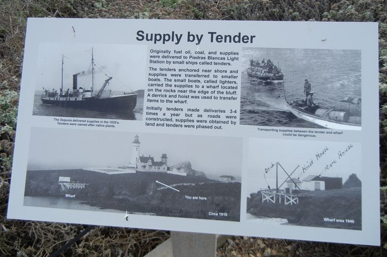
Supply by Tender
The tenders anchored near shore and supplies were transferred to smaller boats. The small boats, called lighters, carried the supplies to a wharf located on the rocks near the edge of the bluff. A derrick and hoist was used to transfer items to the wharf.
Initially tenders made deliveries 3-4 times a year but as roads were constructed, supplies were obtained by land and tenders were phased out.
Captions:
Top left: The Sequoia delivered supplies in the 1930's. Tenders were named after native plants.
Top right: Transporting supplies between the tender and wharf could be dangerous.
Bottom right: Wharf area 1940
Topics. This historical marker is listed in this topic list: Waterways & Vessels. A significant historical year for this entry is 1940.
Location. 35° 39.899′ N, 121° 17.022′ W. Marker is near San Simeon, California, in San Luis Obispo County. Marker can be reached from Cabrillo Highway (California Route 1), on the right when traveling south. Marker is at Piedras Blancas Light Station. Reservations required to access the area. Touch for map. Marker is at or near this postal address: 15950 Cabrillo Highway, San Simeon CA 93452, United States of America. Touch for directions.
Other nearby markers. At least 8 other markers are within 14 miles of this marker, measured as the crow flies. Point Piedras Blancas, A Recent Colony (approx. 1.4 miles away); Hearst Ranch (approx. 5.4 miles away); Sebastian Store (approx. 5.4 miles away); Hearst San Simeon State Historical Monument (approx. 5.6 miles away); Nitt Witt Ridge (approx. 12.4 miles away); Piedras Blancas Lighthouse Lens (approx. 12.6 miles away); Cambria Veterans' Memorial (approx. 12.6 miles away); Preserving a Bit of History (approx. 13.4 miles away). Touch for a list and map of all markers in San Simeon.
Credits. This page was last revised on August 17, 2021. It was originally submitted on August 17, 2021, by Duane and Tracy Marsteller of Murfreesboro, Tennessee. This page has been viewed 90 times since then and 11 times this year. Photos: 1, 2. submitted on August 17, 2021, by Duane and Tracy Marsteller of Murfreesboro, Tennessee.
Editor’s want-list for this marker. Wide shot of marker and surrounding area in context. • Can you help?

