Near Lawrenceville in Brunswick County, Virginia — The American South (Mid-Atlantic)
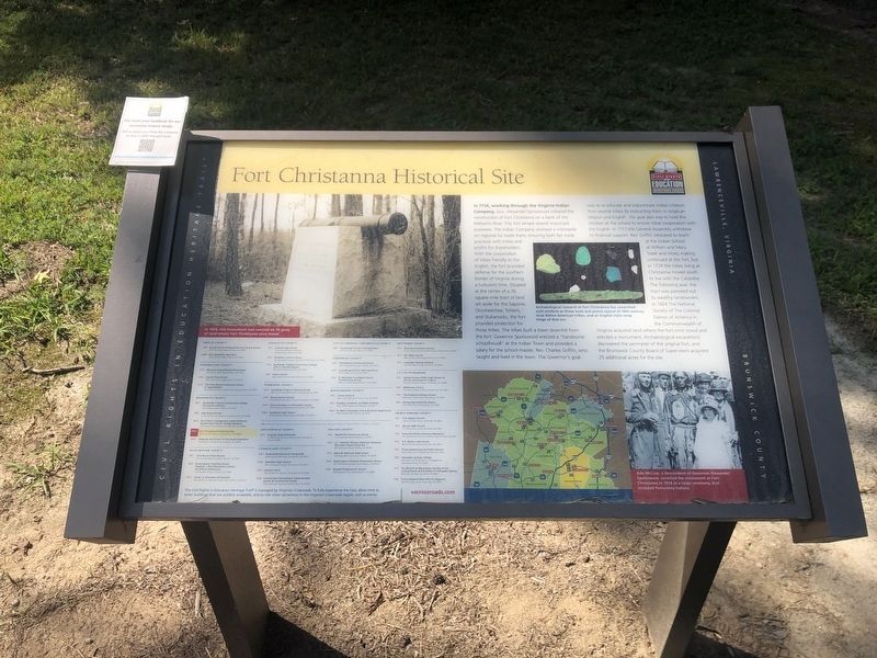
Fort Christanna Historical Site
Lawrenceville, Virginia
— Brunswick County —
In 1714, working through the Virginia Indian Company, Gov. Alexander Spotswood initiated the construction of First Christanna on a bank of the Meherrin River. This fort served several important purposes. The Indian Company received a monopoly on regional fur trade there, ensuring both fair trade practices with tribes and profits for shareholders. With the cooperation of tribes friendly to the English, the fort provided defense for the southern border of Virginia during a turbulent time. Situated at the center of a 36 square-mile tract of land set aside for the Saponie, Occoneechee, Tottero, and Stukanocks, the fort provided protection for those tribes. The tribes built a town downhill from the fort. Governor Spotswood erected a "handsome schoolhouse" at the Indian Town and provided a salary for the school-master, Rev. Charles Griffin, who taught and lived in the town. The Governor's goal was to re-educate and indoctrinate Indian children from several tribes by instructing them in Anglican religion and English. His goal also was to hold the children at the school to ensure tribal cooperation with the English. In 1717 the General Assembly withdrew its financial support. Rev. Griffin relocated to teach at the Indian School at William and Mary Trade and treaty making continued at the fort, but in 1729 the tribes living at Christanna moved south to live with the Catawba. The following year, the tract was parceled out to wealthy landowners. In 1924 The National Society of Colonial Dames of America in the Commonwealth of Virginia acquired land where the fort once stood and erected a monument. Archaeological excavations discovered the perimeter of the original fort, and the Brunswick County Board of Supervisors acquired 25 additional acres for the site.
[Captions:]
In 1924, this monument was erected on 10 acres of land where Fort Christanna once stood.
Archaeological research at Fort Christanna has unearthed such artifacts as these tools and points typical of 18th-century local Native American tribes, and an English-style strap hinge of that era.
Ada McCrae, a descendant of Governor Alexander Spotswood, unveiled the monument at Fort Christanna in 1924 at a large ceremony that included Pamunkey Indians.
Erected by Civil Rights in Education Heritage Trail. (Marker Number BR4.)
Topics and series. This historical marker is listed in these topic lists: Colonial Era • Education • Forts and Castles • Native Americans. In addition, it is included in the Civil Rights in Education Heritage Trail series list. A significant historical year for this entry is 1714.
Location. 36°
Other nearby markers. At least 8 other markers are within 4 miles of this marker, measured as the crow flies. Native Americans and Fort Christanna (about 300 feet away, measured in a direct line); Fort Christanna: Established 1714 (about 300 feet away); Governor Alexander Spotswood (about 300 feet away); Site of Fort Christanna (about 400 feet away); The Colonial Dames of America Monument (about 400 feet away); Fort Christanna (approx. 1.3 miles away); Hospital and School of the Good Shepherd (approx. 2.3 miles away); Goronwy Owen (approx. 3.4 miles away). Touch for a list and map of all markers in Lawrenceville.
Related marker. Click here for another marker that is related to this marker. Old Marker At This Location titled "Fort Christanna".
Credits. This page was last revised on November 3, 2021. It was originally submitted on August 28, 2021, by Devry Becker Jones of Washington, District of Columbia. This page has been viewed 270 times since then and 44 times this year. Photos: 1, 2. submitted on August 28, 2021, by Devry Becker Jones of Washington, District of Columbia.

