Pineville in Bell County, Kentucky — The American South (East South Central)
The Wilderness Road
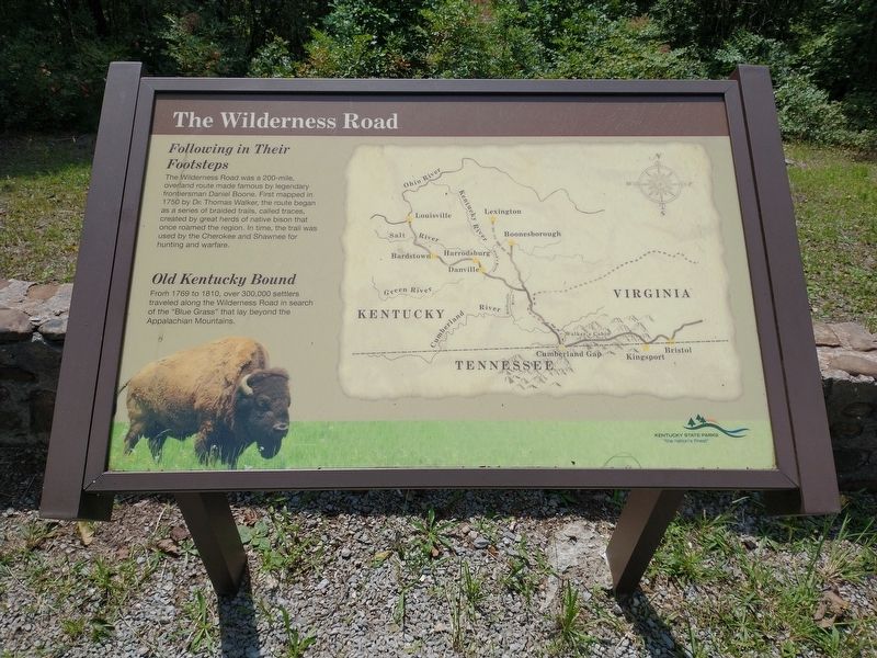
The Wilderness Road was a 200-mil, overland route made famous by legendary frontiersman Daniel Boone. First mapped in 1750 by Dr. Thomas Walker, the route began as a series of braided trails, called traces, created by great herds of native bison that once roamed the region. In time, the trail was used by the Cherokee and Shawnee for hunting and warfare.
Old Kentucky Bound
From 1769 to 1810, over 300,000 settlers traveled along the Wilderness Road in search of the "Blue Grass" that lay beyond the Appalachian Mountains.
Erected by Kentucky State Parks.
Topics. This historical marker is listed in these topic lists: Colonial Era • Roads & Vehicles • Settlements & Settlers. A significant historical year for this entry is 1750.
Location. 36° 44.538′ N, 83° 44.751′ W. Marker is in Pineville, Kentucky, in Bell County. Marker is on State Park Road (Kentucky Route 382), on the right when traveling north. Touch for map. Marker is in this post office area: Pineville KY 40977, United States of America. Touch for directions.
Other nearby markers. At least 8 other markers are within 3 miles of this marker, measured as the crow flies. Invasion and Retreat (approx. 1˝ miles away); First Camp Site In Kentucky (approx. 2.7 miles away); Wallsend Mine (approx. 2.7 miles away); Henderson Settlement (approx. 2.8 miles away); Chained Rock (approx. 2.8 miles away); Wilderness Road Cemetery (approx. 2.9 miles away); Naming of the Cumberland River (approx. 2.9 miles away); a different marker also named The Wilderness Road (approx. 3.1 miles away). Touch for a list and map of all markers in Pineville.
Also see . . .
1. Thomas Walker (explorer). (Submitted on September 6, 2021, by Tom Bosse of Jefferson City, Tennessee.)
2. Wilderness Road. (Submitted on September 6, 2021, by Tom Bosse of Jefferson City, Tennessee.)
Credits. This page was last revised on September 15, 2021. It was originally submitted on September 6, 2021, by Tom Bosse of Jefferson City, Tennessee. This page has been viewed 207 times since then and 18 times this year. Photos: 1, 2, 3. submitted on September 6, 2021, by Tom Bosse of Jefferson City, Tennessee. • Bill Pfingsten was the editor who published this page.


