Near Campbell in Dunklin County, Missouri — The American Midwest (Upper Plains)
The Battle at Chalk Bluff
A State Divided
—
The Civil War in Missouri
—
Photographed by Craig Swain, March 14, 2009
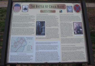
1. The Battle at Chalk Bluff Marker
Inscription.
The Battle at Chalk Bluff. A State Divided.
The Battle at Chalk Bluff. Down the hill from this marker is the place where four brigades of Confederates, led by Brig. Gen. John Sappington Marmaduke, crossed the St. Francis into the safety of Arkansas on May 1-2, 1863. The clash with Union troops at Chalk Bluff was the last fight of Marmaduke's second expedition into Missouri, usually known as the Cape Girardeau Raid, in April 17-May 2, 1863. The fleeing Confederates were hotly pursued by Union troops, led by Gen. John McNeil, and their narrow escape into Arkansas was only successful due to the hasty construction of a makeshift bridge at the crossing., Marmaduke was a week into his southeastern Missouri raid when he decided to attack the important Federal supply depot at Cape Girardeau. He found the town too well defended by the Federal force under McNeil and withdrew to Jackson. Pursued by Union troops, the Confederates left Jackson for Bloomfield on April 27., Nearly constant skirmishing occurred all the way to Bloomfield and their retreat was hindered by persistent rain, muddy roads and high water. After sharp fights at the bridges on the Whitewater and Castor rivers, the Confederates destroyed both of the bridges during their retreat, this forced the Union troops to rebuild them in order to continue their pursuit. Marmaduke intended to fight at Bloomfield, but because his troops were outnumbered, he retreated south toward Chalk Bluff, where he intended to cross the St. Francis River into Arkansas.,
Union Troops Occupy Bloomfield. The pursuing Union troops occupied Bloomfield easily as the Confederates had already begun their retreat by the time the Union forces arrived. Brig. Gen. William Vandever, who had brought reinforcements from Pilot Knob during the Confederate assault on Cape Girardeau, assumed command of the operation. McNeil got his troops under way slowly and was hindered by bad roads that ran through swamps and thick forest. This permitted the rebels to check the Union advance easily. On May 1, McNeil's force skirmished with the Confederate rear guard until they passed through Four Mile, a village located four miles from the St. Francis River., The Confederates established a strong defensive position about a mile farther toward Chalk Bluff at Gravel Hill. With Marmaduke's men concealed behind crude breastworks constructed of logs and brush, the 3rd Missouri Cavalry Regiment (Union), charged into the ambush and received severe fire from the Confederates. Unable to withstand the punishment, the regiment fell back until the Union artillery and reinforcements could be brought forward. Although full of fight by this time, McNeil's men accomplished little before darkness fell.,
Confederates Build a Bridge at Chalk Bluff. Before leaving Bloomfield on April 30, Marmaduke sent a detail of unarmed men forward to construct a bridge over the flooded St. Francis River at Chalk Bluff. The detail, commanded by Maj. Robert Smith, built a rickety bridge of logs tied together with rope and vines anchored on each bank. They also built a log raft to convey the artillery across the treacherous river. Gen. M. Jeff Thompson, the "Swamp Fox," assisted in building the rickety bridge., During the night on May 1, the Confederates began withdrawing across the St. Francis River, one brigade at a time, to the high ground at Chalk Bluff on the Arkansas side. The fragile bridge supported only a single file of troops. Horses had to swim the swirling river and several drowned in the process. Thompson, in charge of crossing the artillery, disassembled the guns and sent the parts over the river on a raft. By daylight on May 2, Marmaduke's entire command, except pickets and a few stragglers, had crossed the river, with the Federals totally unaware of the movement. The Confederates cast off the bridge and raft and then let them drift away downstream., Later that morning, McNeil's brigades moved toward the river, hoping to destroy the Confederate command. The rebels on the Arkansas shore greeted them with heavy fire that unhorsed McNeil and his aide and killed and wounded several of his men. The Union artillery opened a heavy but ineffective cannonade. The Confederates marched away without loss, thus concluding the fight at Chalk Bluff.,
Aftermath of the Battle of Chalk Bluff. Casualties from the encounter at Chalk Bluff cannot be determined with certainty, but they were doubtless low. Vandever estimated Union losses at no more than 50 killed, wounded and missing. The Confederates probably suffered similar losses., Marmaduke scored a tactical victory at Chalk Bluff by avoiding a major engagement with his back against the river, thereby saving his army. But strategically his raid had been a failure. He could not maintain a presence in Missouri and gained only enough recruits to replace his losses. His men remained poorly armed and fed. The raid did not divert the Federals from moving into northern Arkansas. Gen. U.S. Grant initiated his final campaign for Vicksburg on May 1 by defeating the Confederates at Port Gibson, Miss. This was the same day that Marmaduke fought a delaying action to avoid disaster on the St. Francis River., (Sidebar):
The Camp Girardeau Raid. Brig. Gen. John S. Marmaduke's second expedition into Missouri in 1863 is usually known as the Cape Girardeau Raid. Marmaduke undertook the raid to show a Confederate presence in Missouri, recruit men, and gather provisions for his ill-supported brigades. As with Marmaduke's first expedition in January 1863, Confederate authorities hoped that a Missouri incursion would relieve Federal pressure on Little Rock and Vicksburg. At the time of the second raid, Union forces had major bases at Cape Girardeau and Pilot Knob, occupied the primary towns in the region such as Fredericktown and Bloomfield and maned outposts along the major roads leading toward Arkansas at such towns as Patterson., On April 18, 1863, Marmaduke entered southeast Missouri in two columns. He led about 5,000 men including nearly 1,200 unarmed and 900 afoot due to a shortage of weapons and mounts. Colonels John Q. Burbridge, Colton Greene, and Joseph O. Shelby commanded three brigades of Missourians and Arkansans; Col. George W. Carter commanded a brigade of Texas troopers. Missouri and Texas artillery batteries totaling eight guns accompanied the expedition., After stampeding the small garrison at Patterson on April 20, Marmaduke targeted Gen. John McNeil, a man despised by Confederates for executing prisoners in northeast Missouri in 1862. McNeil commanded the garrison at Bloomfield. Marmaduke dispatched Carter's Texas Brigade to drive McNeil from Bloomfield to Fredericktown where Marmaduke planned to entrap the Yankee and his command. McNeil escaped Bloomfield before Carter arrived but, instead of marching toward Fredericktown, rode rapidly to Cape Girardeau with the Texans in pursuit. Marmaduke moved to Cape Girardeau to assist Carter, but Union forces repulsed his attack there on April 26. The Confederates disengaged and camped that night at Jackson. Assaulted the next morning by Gen. William Vandever's Union reinforcements from Pilot Knob, Marmaduke's brigades began a fighting retreat to Arkansas.
The Battle at Chalk Bluff
Down the hill from this marker is the place where four brigades of Confederates, led by Brig. Gen. John Sappington Marmaduke, crossed the St. Francis into the safety of Arkansas on May 1-2, 1863. The clash with Union troops at Chalk Bluff was the last fight of Marmaduke's second expedition into Missouri, usually known as the Cape Girardeau Raid, in April 17-May 2, 1863. The fleeing Confederates were hotly pursued by Union troops, led by Gen. John McNeil, and their narrow escape into Arkansas was only successful due to the hasty construction of a makeshift bridge at the crossing.
Marmaduke was a week into his southeastern Missouri raid when he decided to attack the important Federal supply depot at Cape Girardeau. He found the town too well defended by the Federal force under McNeil and withdrew to Jackson. Pursued by Union troops, the Confederates left Jackson for Bloomfield on April 27.
Nearly constant skirmishing occurred all the way to Bloomfield and their retreat was hindered by persistent rain, muddy roads and high water. After sharp fights at the bridges on the Whitewater and Castor rivers,
Click or scan to see this page online
the Confederates destroyed both of the bridges during their retreat, this forced the Union troops to rebuild them in order to continue their pursuit. Marmaduke intended to fight at Bloomfield, but because his troops were outnumbered, he retreated south toward Chalk Bluff, where he intended to cross the St. Francis River into Arkansas.
Union Troops Occupy Bloomfield
The pursuing Union troops occupied Bloomfield easily as the Confederates had already begun their retreat by the time the Union forces arrived. Brig. Gen. William Vandever, who had brought reinforcements from Pilot Knob during the Confederate assault on Cape Girardeau, assumed command of the operation. McNeil got his troops under way slowly and was hindered by bad roads that ran through swamps and thick forest. This permitted the rebels to check the Union advance easily. On May 1, McNeil's force skirmished with the Confederate rear guard until they passed through Four Mile, a village located four miles from the St. Francis River.
The Confederates established a strong defensive position about a mile farther toward Chalk Bluff at Gravel Hill. With Marmaduke's men concealed behind
Photographed by Craig Swain, March 14, 2009
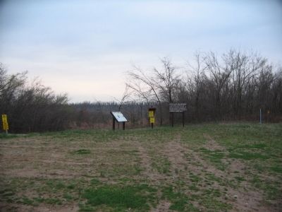
2. The Battle at Chalk Bluff Markers
crude breastworks constructed of logs and brush, the 3rd Missouri Cavalry Regiment (Union), charged into the ambush and received severe fire from the Confederates. Unable to withstand the punishment, the regiment fell back until the Union artillery and reinforcements could be brought forward. Although full of fight by this time, McNeil's men accomplished little before darkness fell.
Confederates Build a Bridge at Chalk Bluff
Before leaving Bloomfield on April 30, Marmaduke sent a detail of unarmed men forward to construct a bridge over the flooded St. Francis River at Chalk Bluff. The detail, commanded by Maj. Robert Smith, built a rickety bridge of logs tied together with rope and vines anchored on each bank. They also built a log raft to convey the artillery across the treacherous river. Gen. M. Jeff Thompson, the "Swamp Fox," assisted in building the rickety bridge.
During the night on May 1, the Confederates began withdrawing across the St. Francis River, one brigade at a time, to the high ground at Chalk Bluff on the Arkansas side. The fragile bridge supported only a single file of troops. Horses had to swim the swirling river and
Photographed by Craig Swain, March 14, 2009
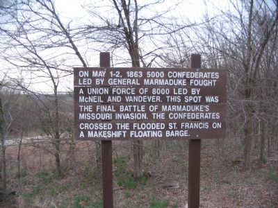
3. Original Sign
This sign was placed before the interpretive marker.
several drowned in the process. Thompson, in charge of crossing the artillery, disassembled the guns and sent the parts over the river on a raft. By daylight on May 2, Marmaduke's entire command, except pickets and a few stragglers, had crossed the river, with the Federals totally unaware of the movement. The Confederates cast off the bridge and raft and then let them drift away downstream.
Later that morning, McNeil's brigades moved toward the river, hoping to destroy the Confederate command. The rebels on the Arkansas shore greeted them with heavy fire that unhorsed McNeil and his aide and killed and wounded several of his men. The Union artillery opened a heavy but ineffective cannonade. The Confederates marched away without loss, thus concluding the fight at Chalk Bluff.
Aftermath of the Battle of Chalk Bluff
Casualties from the encounter at Chalk Bluff cannot be determined with certainty, but they were doubtless low. Vandever estimated Union losses at no more than 50 killed, wounded and missing. The Confederates probably suffered similar losses.
Marmaduke scored a tactical victory at Chalk Bluff by avoiding a major engagement with
Photographed by Craig Swain, March 19, 2009
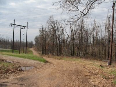
4. Four Mile
Located, as the name implies, four miles east of Chalk Bluff where Missouri Highway 53 crosses over Crowley's Ridge, is the site of the village of Four Mile. A gravel road passes along the top of Crowley's Ridge here, and is approximately along the same course taken by the military road at the time of the battle. A nearby cemetery and at least one house nearby date to the time of the battle.
his back against the river, thereby saving his army. But strategically his raid had been a failure. He could not maintain a presence in Missouri and gained only enough recruits to replace his losses. His men remained poorly armed and fed. The raid did not divert the Federals from moving into northern Arkansas. Gen. U.S. Grant initiated his final campaign for Vicksburg on May 1 by defeating the Confederates at Port Gibson, Miss. This was the same day that Marmaduke fought a delaying action to avoid disaster on the St. Francis River.
(Sidebar):
The Camp Girardeau Raid
Brig. Gen. John S. Marmaduke's second expedition into Missouri in 1863 is usually known as the Cape Girardeau Raid. Marmaduke undertook the raid to show a Confederate presence in Missouri, recruit men, and gather provisions for his ill-supported brigades. As with Marmaduke's first expedition in January 1863, Confederate authorities hoped that a Missouri incursion would relieve Federal pressure on Little Rock and Vicksburg. At the time of the second raid, Union forces had major bases at Cape Girardeau and Pilot Knob, occupied the primary towns in the region such as Fredericktown
Photographed by Craig Swain, March 14, 2009
5. Gravel Hill Cemetery
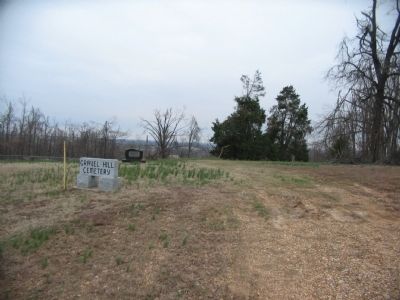
About half way between Four Mile and the river crossing point is Gravel Hill Cemetery. Here Confederates built breastworks to fight a delaying action. The pursuing 3rd Missouri (Union) Cavalry was repulsed here.
and Bloomfield and maned outposts along the major roads leading toward Arkansas at such towns as Patterson.
On April 18, 1863, Marmaduke entered southeast Missouri in two columns. He led about 5,000 men including nearly 1,200 unarmed and 900 afoot due to a shortage of weapons and mounts. Colonels John Q. Burbridge, Colton Greene, and Joseph O. Shelby commanded three brigades of Missourians and Arkansans; Col. George W. Carter commanded a brigade of Texas troopers. Missouri and Texas artillery batteries totaling eight guns accompanied the expedition.
After stampeding the small garrison at Patterson on April 20, Marmaduke targeted Gen. John McNeil, a man despised by Confederates for executing prisoners in northeast Missouri in 1862. McNeil commanded the garrison at Bloomfield. Marmaduke dispatched Carter's Texas Brigade to drive McNeil from Bloomfield to Fredericktown where Marmaduke planned to entrap the Yankee and his command. McNeil escaped Bloomfield before Carter arrived but, instead of marching toward Fredericktown, rode rapidly to Cape Girardeau with the Texans in pursuit. Marmaduke moved to Cape Girardeau to assist Carter, but Union
Photographed by Craig Swain, March 14, 2009
6. Repulse of the 3rd Missouri (Union) Cavalry
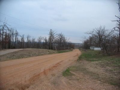
Looking east from Gravel Hill Cemetery. The road here is approximately the same course used by the wartime military road. The lead Federal unit, the 3rd Missouri Cavalry, advanced up the military road and met Confederates entrenched behind breastworks along the top of Crowley's Ridge near this point. The Federals were thrown back, gaining the time needed for the Confederates to escape across the St. Francis River.
forces repulsed his attack there on April 26. The Confederates disengaged and camped that night at Jackson. Assaulted the next morning by Gen. William Vandever's Union reinforcements from Pilot Knob, Marmaduke's brigades began a fighting retreat to Arkansas.
Erected by Missouri Department of Natural Resources.
Location. 36° 29.115′ N, 90° 9.233′ W. Marker is near Campbell, Missouri, in Dunklin County. It is on County Route 228, on the left when traveling west. Located in a parking area uphill from public access boat ramp on the St. Francis River. Touch for map. Marker is in this post office area: Campbell MO 63933, United States of America. Touch for directions.
Regionally, this marker is in the Missouri Bootheel. It is also in the American Mississippi Delta, in the Ozarks, in the Lewis & Clark Corridor, and in the Corn Belt. Globally,
Photographed by Craig Swain, March 14, 2009
7. St. Francis River at the Boat Ramp
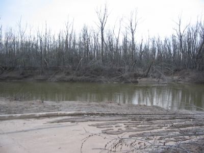
At the base of the bluff on which the marker is located is this boat ramp providing access to the river. The actual crossing site was likely a few hundred yards further south, near a ferry crossing point.
it is in North America, the Western Hemisphere, the Western World, and the Anglosphere. Historically, it finds itself in what was once the territory of the Mississippian Culture, the Louisiana Purchase, and the Antebellum South.
More about this marker. The marker displays portraits of Gens. McNeil, Vandever, Marmaduke and Thompson. In the sidebar is a map showing the routes taken by Marmaduke's command during the raid.
Related markers. Click here for a list of markers that are related to this marker. The Battles around Chalk Bluff
Credits. This page was last revised on November 22, 2024. It was originally submitted on April 20, 2009, by Craig Swain of Leesburg, Virginia. This page has been viewed 5,057 times since then and 151 times this year. Photos:1. submitted on April 20, 2009, by Craig Swain of Leesburg, Virginia. 2, 3, 4, 5, 6, 7. submitted on April 21, 2009, by Craig Swain of Leesburg, Virginia.