Downtown Juneau in Juneau Borough, Alaska — Northwest (North America)
Cape Hinchinbrook
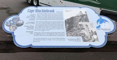
Perched high on a cliff, Cape Hinchinbrook lighthouse marks the entrance to the sheltered waters of Prince William Sound. The wreck of the steamer Oregon on Hinchinbrook Island in 1906 prompted the light's installation. Foul weather during construction washed away a scow filled with building materials, and work was not complete when winter arrived. Nevertheless, a keeper and his wife stayed in the unfinished building all winter to tend a temporary light.
When finished, the light tower rose from the pyramid-shaped roof of an octagonal building of reinforced concrete and wood. The ground floor housed equipment and the second floor had living quarters for four keepers. These cliff dwellers were completely cut off from rest of world for a year at a time. Two of them did not speak to one another for their last six months there because of an argument over whether to have their potatoes mashed or fried.
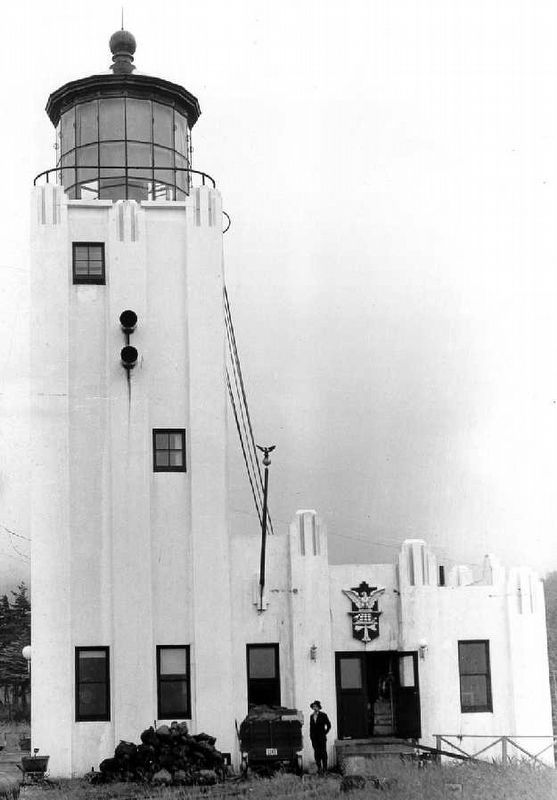
Earthquakes in 1927 and 1928 undermined the cliff on which the lighthouse stood. A new lighthouse, built of reinforced concrete in 1934, stood 130 feet farther back, on solid ground.
The original Fresnel lens is now at the Valdez Museum and Historical Archive in Valdez. The Coast Guard manages the site.
At-a-glance box
• Location: entrance to Prince William Sound, 37 miles southwest of Cordova
• First lighted: Nov. 15, 1910
• Original Optics: third-order Fresnel lens
• Automated: 1974
Captions
(Top) The original cliff-side lighthouse. (US Coast Guard Photo)
(Bottom) The new Cape Hinchinbrook lighthouse, set back from the cliff's face. (US Coast Guard Photo)
Topics and series. This historical marker is listed in these topic lists: Communications • Women. In addition, it is included in the Lighthouses series list. A significant historical date for this entry is November 15, 1910.
Location. 58° 17.908′ N, 134° 24.317′ W. Marker is in Juneau, Alaska, in Juneau Borough. It is in Downtown Juneau. Marker can be reached from Marine Way. Marker is on the Juneau Harbor boardwalk, south of Marine Park and across from the cruise ship berths. Touch for map. Marker is at or near this postal address: 252 Marine Way, Juneau AK 99801, United States of America. Touch for directions.
Other nearby markers. At least 8 other markers are within walking distance of this marker. Eldred Rock (here, next to this marker); Cape Saint Elias (here, next to this marker); Cape Sarichef & Scotch Cap (here, next to this marker); Cape Spencer (here, next to this marker); Lincoln Rock, Fairway Island & Point Sherman (here, next to this marker); Point Retreat (here, next to this marker); Guard Islands (here, next to this marker); Tree Point (a few steps from this marker). Touch for a list and map of all markers in Juneau.
Also see . . .
1. Cape Hinchinbrook Lighthouse. Lighthousefriends entry on the site. (Submitted on September 12, 2021, by Duane and Tracy Marsteller of Murfreesboro, Tennessee.)
2. SS Oregon (1878). Wikipedia entry on the ill-fated steamer, which was considered a cursed ship by crews after several hull breaches — and before it was involved in a fatal collision seven years ahead of her ultimate demise. (Submitted on September 12, 2021, by Duane and Tracy Marsteller of Murfreesboro, Tennessee.)

via NPS, unknown
3. Cape Hinchinbrook Light Station
National Register of Historic Places Digital Archive on NPGallery website entry
Click for more information.
Click for more information.
Credits. This page was last revised on January 5, 2022. It was originally submitted on September 12, 2021, by Duane and Tracy Marsteller of Murfreesboro, Tennessee. This page has been viewed 236 times since then and 17 times this year. Photos: 1, 2, 3. submitted on September 12, 2021, by Duane and Tracy Marsteller of Murfreesboro, Tennessee.

