Ann Arbor in Washtenaw County, Michigan — The American Midwest (Great Lakes)
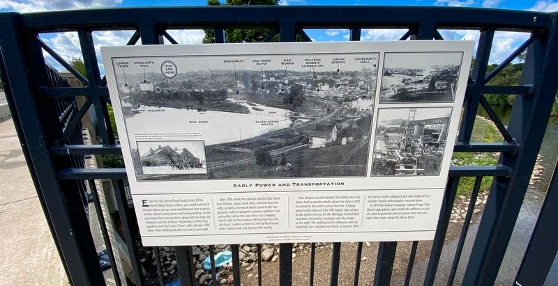
Early Power and Transportation
After 1839, when the railroad reached Ann Arbor from Detroit, paper, wool, flour, and feed from the mills, as well as livestock held in pens in the foreground, could be shipped to eastern markets. Coal arrived by rail for the Ann Arbor Gas company, which built its first works in 1858 across from the old depot. Lumber arrived for Selleck Wood’s and other lumberyards and planning mills nearby.
Ann Arbor’s second railroad, the Toledo and Ann Arbor, built a wood trestle above the dam in 1881 to extend its line north across the river. A flimsy metal trestle replaced it by 1894 (upper right photo). In that photo you can see the Michigan Central Railroad had a locomotive turntable near the bridge on the right. The building on the millpond, with the long dock, was a popular boat livery. In January 1904 the metal trestle collapsed and was replaced by a sturdier trestle with massive concrete piers.
In 1914 the Edison Company replaced Argo Dam (lower right photo) and rebuilt the millrace as part of a plan to generate electric power from this and eight other dams along the Huron River.
Topics. This historical marker is listed in these topic lists: Railroads & Streetcars • Roads & Vehicles • Waterways & Vessels. A significant historical month for this entry is January 1904.
Location. 42° 17.316′ N, 83° 44.423′ W. Marker is in Ann Arbor, Michigan, in Washtenaw County. Marker is on Broadway Street near Swift Street, on the right when traveling south. Located on the west side of the Broadway Street bridge over the Huron River. Touch for map. Marker is at or near this postal address: 987 Broadway St, Ann Arbor MI 48105, United States of America. Touch for directions.
Other nearby markers. At least 8 other markers are within walking distance of this marker. The Agricultural Works and Lower Town (here, next to this marker); From Industry to Parks (a few steps from this marker); Lower Town's Flour Mills (a few steps from this marker); The Center of Power And Transportation (a few steps from this marker); Michigan Central Railroad Depot (about 600 feet away, measured in a direct line); Brown and Fuller's Addition—1832 (approx. ¼ mile away); Anson Brown and Early Lower Town (approx. ¼ mile away); Homes of Early Lower Town Settlers (approx. ¼ mile away). Touch for a list and map of all markers in Ann Arbor.
Credits. This page was last revised on September 22, 2021. It was originally submitted on September 20, 2021, by J.T. Lambrou of New Boston, Michigan. This page has been viewed 113 times since then and 11 times this year. Photos: 1, 2, 3. submitted on September 20, 2021, by J.T. Lambrou of New Boston, Michigan. • Mark Hilton was the editor who published this page.


