Gravesend in Brooklyn in Kings County, New York — The American Northeast (Mid-Atlantic)
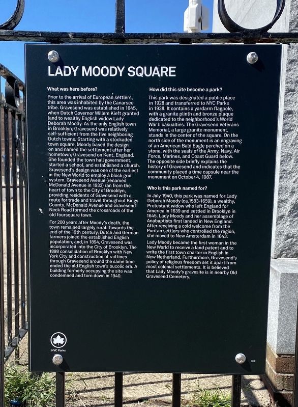
Lady Moody Square
What was here before?
Prior to the arrival of European settlers, this area was inhabited by the Canarsee tribe. Gravesend was established in 1645, when Dutch Governor Willem Kieft granted land to wealthy English widow Lady Deborah Moody. As the only English town in Brooklyn, Gravesend was relatively self-sufficient from the five neighboring Dutch towns. Starting with a stockaded town square, Moody based the design on and named the settlement after her hometown, Gravesend on Kent, England. She founded the town hall government, started a school, and established a church. Gravesend's design was one of the earliest in the New World to employ a block grid system. Gravesend Avenue (renamed McDonald Avenue in 1933) ran from the heart of town to the City of Brooklyn, providing residents of Gravesend with a route for trade and travel throughout Kings County. McDonald Avenue and Gravesend Neck Road formed the crossroads of the old foursquare town.
For 200 years after Moody's death, the town remained largely rural. Towards the end of the 19th century, Dutch and German farmers joined the established English population, and, in 1894, Gravesend was incorporated into the City of Brooklyn. The 1898 consolidation of Brooklyn with New York City and construction of rail lines through Gravesend around the same time ended the old English town's bucolic era. A building formerly occupying the site was condemned and torn down in 1940.
How did this site become a park?
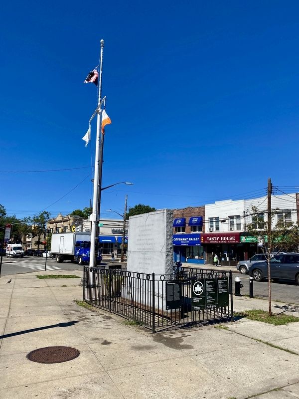
This park was designated a public place in 1928 and transferred to NYC Parks in 1938. It contains a yardarm flagpole, with a granite plinth and bronze plaque dedicated to the neighborhood's World War II casualties. The Gravesend Veterans Memorial, a large granite monument, stands in the center of the square. On the north side of the monument is an engraving of an American Bald Eagle perched on a stone, with the seals of the Army, Navy, Air Force, Marines, and Coast Guard below. The opposite side briefly explains the history of Gravesend and indicates that the community placed a time capsule near the monument on October 4, 1987.
Who is this park named for?
In July 1940, this park was named for Lady Deborah Moody (ca.1583-1659), a wealthy, Protestant widow who left England for America in 1639 and settled in Brooklyn in 1645. Lady Moody and her assemblage of Anabaptists first landed in New England. After receiving a cold welcome from the Puritan settlers who controlled the region, she moved to New Amsterdam in 1643.
Lady Moody became the first woman in the New World to receive a land patent and to write the first town
charter in English in
New Netherland. Furthermore, Gravesend's
policy of religious freedom set it apart from
most colonial settlements. It is believed
that Lady Moody's gravesite is in nearby Old
Gravesend Cemetery.
Erected by NYC Parks.
Topics and series. This historical marker is listed in these topic lists: Parks & Recreational Areas • Settlements & Settlers • Women. In addition, it is included in the NYC Parks series list.
Location. 40° 35.804′ N, 73° 58.467′ W. Marker is in Brooklyn, New York, in Kings County. It is in Gravesend. Marker is on Avenue U, on the left when traveling west. Touch for map. Marker is in this post office area: Brooklyn NY 11223, United States of America. Touch for directions.
Other nearby markers. At least 8 other markers are within walking distance of this marker. Gravesend (here, next to this marker); Gravesend Veterans Memorial (here, next to this marker); Gravesend Cemetery (about 600 feet away, measured in a direct line); The Battle of Brooklyn (about 600 feet away); a different marker also named Gravesend (about 600 feet away); PO Jeff Herman Ballfield (approx. ¼ mile away); McDonald Playground (approx. 0.3 miles away); Meucci Triangle (approx. half a mile away). Touch for a list and map of all markers in Brooklyn.
Also see . . . Meet Lady Deborah Moody, The ‘Dangerous Woman’ Who Founded Gravesend....(Allthatsinteresting.com) .
Excerpt: After Lady Moody became the first woman to found a settlement in the New World in 1645, she then established one of the first “grid systems” in what would later become New York City.(Submitted on October 28, 2021.)
This is the story of Lady Deborah Moody, the religious dissenter, landowner, and urban planner who was the first woman to found a settlement in the New World — and one of the first people to establish a “grid system” in what would later become New York City."
Credits. This page was last revised on January 31, 2023. It was originally submitted on October 27, 2021, by Andrew Ruppenstein of Lamorinda, California. This page has been viewed 284 times since then and 48 times this year. Photos: 1, 2. submitted on October 27, 2021, by Andrew Ruppenstein of Lamorinda, California.

