Bourbon in Marshall County, Indiana — The American Midwest (Great Lakes)
The Lincoln Highway
America's First Coast to Coast Highway
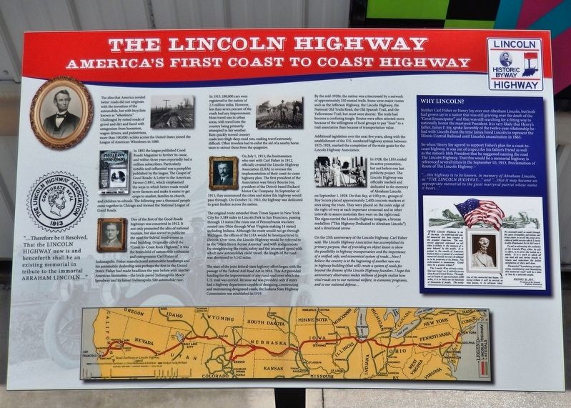
The idea that America needed better roads did not originate with the invention of the automobile, but with bicyclists known as "wheelmen." Challenged by rutted roads of gravel and dirt and faced with antagonism from horsemen, wagon drivers, and pedestrians, more than 100,000 cyclists across the United States joined the League of American Wheelmen in 1880.
In 1892 the league published Good Roads Magazine to further its cause, and within three years reportedly had a million subscribers. Particularly notable and influential was a pamphlet published by the league, The Gospel of Good Roads: A Letter to the American Farmer (1891), which emphasized the ways in which better roads would serve farmers and make it easier to get crops to market, families to church, and children to schools. The following year a thousand people came together in Chicago and formed the National league of Good Roads.
One of the first of the Good Roads highways was conceived in 1912. It not only promoted the idea of national tourism, but also served to publicize the need for federal involvement in road building. Originally called the "Coast-to-Coast Rock Highway," it was the brainchild of automobile enthusiast and entrepreneur Carl Fisher of Indianapolis. Fisher manufactured automobile headlamps and his automobile dealership was perhaps the first in the United States. Fisher had made headlines the year before with another American institution—the brick-paved Indianapolis Motor Speedway and its famed Indianapolis 500 automobile race.
In 1913, 180,000 cars were registered in the nation of 2.5 million miles. However, less than seven percent of the roads had any improvement. Most travel was in urban areas, with travel into the country being primarily attempted in fair weather. Rain quickly turned country roads into thigh-deep mud ruts, making travel extremely difficult. Often travelers had to enlist the aid of a nearby horse team to extract them from the quagmire.
On July 1, 1913, the businessmen who met with Carl Fisher in 1912, officially created the Lincoln Highway Association (LHA) to oversee the implementation of their coast-to-coast highway plan. The first president of the Association was Henry Bourne Joy, president of the Detroit based Packard Motor Car Company. In September of 1913, they announced the cities and states this highway would pass through. On October 31, 1913, the highway was dedicated to great fanfare across the nation.
The original route extended from Times Square in New York City for 3,389 miles to Lincoln Park in San Francisco, passing through 13 states (the route out of Pennsylvania was later routed into Ohio through West Virginia making 14 states) including Indiana. Although the
route would not go through Michigan, the offices of the LHA would be headquartered in Detroit. Over time, the Lincoln Highway would be referred to as the "Main Street Across America" and with realignments for straightening the route, safety and the increased speed with which new automobiles could travel, the length of the road was shortened to 3,142 miles.
The start of the joint federal-state highway effort began with the passage of the Federal Aid Road Act in 1916. This Act provided funding for the improvement of any rural road over which the U.S. mail was carried. Because aid was provided only if states had a highway department capable of designing, constructing and maintaining designated roads, the Indiana State Highway Commission was established in 1919.
By the mid-1920s, the nation was crisscrossed by a network of approximately 250 named trails. Some were major routes such as the Jefferson Highway, the Lincoln Highway, the National Old Trails Road, the Old Spanish Trail, and the Yellowstone Trail, but most were shorter. The trails had become a confusing tangle. Routes were often selected more because of the willingness of local groups to pay "dues" to a trail association than because of transportation value.
Additional legislation over the next few years, along with the establishment of the U.S. numbered highway system between 1925-1928, marked the completion of the main goals for the Lincoln Highway Association.
In 1928, the LHA ended its active promotion, but not before one last publicity project. The Lincoln Highway was officially marked and dedicated to the memory of Abraham Lincoln on September 1, 1928. On that day, at 1:00 p.m., groups of Boy Scouts placed approximately 2,400 concrete markers at sites along the route. They were placed on the outer edge of the right-of-way at each important crossroad and at other intervals to assure motorists they were on the right road. The signs carried the Lincoln Highway insignia, a bronze medallion ("This Highway Dedicated to Abraham Lincoln") and a directional arrow.
On the 25th anniversary of the Lincoln Highway, Carl Fisher said: The Lincoln Highway Association has accomplished its primary purpose, that of providing an object lesson to show the possibility in highway transportation and the importance of a unified, safe, and economical system of roads… Now I believe the country is at the beginning of another new era in highway building (that will) create a system of roads far beyond the dreams of the Lincoln Highway founders. I hope this anniversary observance makes millions of people realize how vital roads are to our national welfare, to economic programs, and to our national defense…
Why Lincoln?
Neither Carl Fisher or Henry Joy ever
met Abraham Lincoln, but both had grown up in a nation that was still grieving over the death of the "Great Emancipator" and that was still searching for a fitting way to nationally honor the martyred President. It is very likely that Henry's father, James F. Joy, spoke favorably of the twelve-year relationship he had with Lincoln from the time James hired Lincoln to represent the Illinois Central Railroad until Lincoln's assassination in 1865.
So when Henry Joy agreed to support Fisher's plan for a coast-to-coast highway, it was out of respect for his father's friend as well as the nation's 16th President that he suggested naming the road The Lincoln Highway. That this would be a memorial highway is referenced several times in the September 10, 1913, Proclamation of Route of The Lincoln Highway —
"...this highway is to be known, in memory of Abraham Lincoln, as "THE LINCOLN HIGHWAY…" and "...that it may become an appropriate memorial to the great martyred patriot whose name it bears…"
The Lincoln Highway is on the map. An enduring and useful memorial has been created to the greatest American. The universal approval expressed on all sides is tribute to the memory of a man beloved by the people. It is unique in the annals of American history that a proposal of a national memorial should not even be debated as to its propriety or its fitness. The endorsement is unanimous. Could there be a greater tribute?
The Lincoln Way already exists. One can travel on it entirely across these broad United States. Throughout its length of approximately 3,500 miles, it is in daily use by hundreds of thousands of people. The evolution of this memorial has begun. In loving tribute it will be carried, as time Passes, to its ultimate ideal.
No cenotaph could so much through the years strengthen patriotism and bring closer to us all the great principles of public service which Lincoln so ably illuminated by his life's work.
To aid in advancing the evolution of the Lincoln Way, either by gift or effort, is to serve the nation as a whole. It is a work to which all can lend aid and derive benefit in return and experience the golden satisfaction of duty well done.
The work of "broadening, straightening, maintaining and beautifying this memorial road" will be a labor of love by a patriotic people.
Henry B. Joy,
President of the Lincoln Highway Association
Topics and series. This historical marker is listed in these topic lists: Charity & Public Work • Fraternal or Sororal Organizations • Patriots & Patriotism • Roads & Vehicles. In addition, it is included in the Former U.S. Presidents: #16 Abraham Lincoln, and the Lincoln Highway series lists. A significant historical year for this entry is 1913.
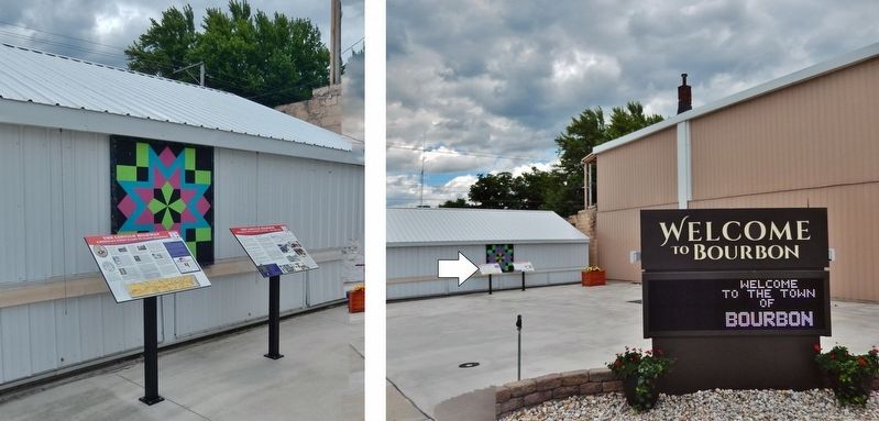
Location. 41° 17.725′ N, 86° 6.955′ W. Marker is in Bourbon, Indiana, in Marshall County. Marker is at the intersection of South Main Street (Indiana Route 331) and Lincoln Highway (Center Street), on the right when traveling north on South Main Street. Marker is located in the Bourbon Farmers Market plaza at the southeast corner of the intersection. Touch for map. Marker is at or near this postal address: 103 South Main Street, Bourbon IN 46504, United States of America. Touch for directions.
Other nearby markers. At least 8 other markers are within 4 miles of this marker, measured as the crow flies. A different marker also named The Lincoln Highway (here, next to this marker); The Bourbon Boys (within shouting distance of this marker); Old Town Pump (within shouting distance of this marker); Parks IOOF Cemetery (approx. 0.4 miles away); Early Bourbon Cemetery (approx. half a mile away); Pleasant Hill Cemetery (approx. 1½ miles away); Mount Pleasant South Cemetery (approx. 3.7 miles away); Mount Pleasant North Cemetery (approx. 3.7 miles away). Touch for a list and map of all markers in Bourbon.
Related markers. Click here for a list of markers that are related to this marker.
Credits. This page was last revised on October 30, 2021. It was originally submitted on October 28, 2021, by Cosmos Mariner of Cape Canaveral, Florida. This page has been viewed 176 times since then and 34 times this year. Photos: 1. submitted on October 29, 2021, by Cosmos Mariner of Cape Canaveral, Florida. 2, 3. submitted on October 30, 2021, by Cosmos Mariner of Cape Canaveral, Florida. 4. submitted on October 29, 2021, by Cosmos Mariner of Cape Canaveral, Florida.


