Santa Fe in Santa Fe County, New Mexico — The American Mountains (Southwest)
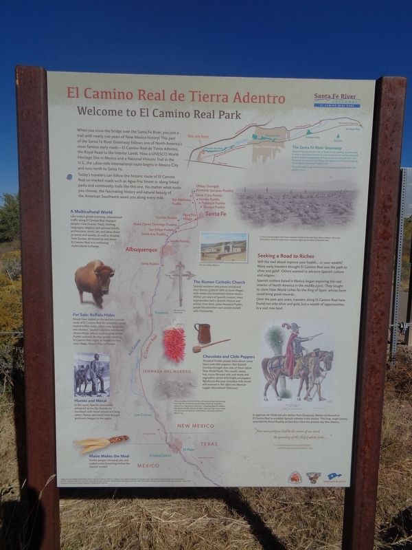
El Camino Real de Tierra Adentro
Welcome to El Camino Real Park
Today's travelers can follow the historic route of El Camino Real on marked roads such as Agua Fria Street or along linked parks and community trails like this one. No matter what route you choose, the fascinating history and natural beauty of the American Southwest await you along every mile.
A Multicultural World
Like today's global economy, international traffic along El Camino Real changed people's lives forever. Food, clothing, languages, religious and spiritual beliefs, architecture, music, art, and ideas about property and society, as well as diseases from Europe, all moved up and down El Camino Real in a continuing multicultural exchange.
For Sale: Buffalo Hides
People have traded on the ancient riverside route of El Camino Real for centuries. Locals traded buffalo hides, pinon nuts, turquoise, and obsidian. Spanish colonists introduced churro sheep, whose wool inspired skilled Pueblo weavers. By 1650, goods traveling El Camino Real might be headed for the next village, Mexico City, or Europe.
Horses and Metal
In the 1500s, Spanish newcomers advanced up to the Rio Grande on horseback with metal swords and body armor. Horses and metal tools brought profound changes to the region.
Maize Makes the Meal
Pueblo people cultivated, ate, and traded maize (corn) long before the Spanish arrived.
The Santa Fe River Greenway
Santa Fe County and the City of Santa Fe are working in partnership to restore the Santa Fe River to a more natural and healthy state and build a continuous greenway of trails and parks along the river. The Greenway is a retracement hiking trail segment of El Camino Real de Tierra Adentro National Historic Trail.
The trail length is one mile and has a continuous paved service with gradual slopes.
The Roman Catholic Church
Spanish explorers and priests introduced their Roman Catholic faith to local villages, with mixed and sometimes violent results. Within 100 years of Spanish contact, most large pueblos had a Spanish mission and priests. Over time, some Ancestral Pueblo people blended their own ancient beliefs with Christianity.
Seeking a Road
to Riches
Will the trail ahead improve your health…or your wealth? Many early travelers thought El Camino Real was the path to silver and gold! Others wanted to advance Spanish culture and religion.
Spanish soldiers based in Mexico began exploring the vast interior of North America in the middle 1500s. They sought to claim New World riches for the King of Spain, whose favor could bring great rewards.
Over the past 400 years, travelers along El Camino Real have found not only silver and gold, but a wealth of opportunities in a vast new land.
Chocolate and Chile Peppers
Ancestral Pueblo people knew about cocoa beans and chile peppers - but Spanish travelers brought new uses of these native New World foods. The results: sweet, hot, cocoa-flavored milk, and meats and vegetables spiced with bright red peppers. Would you like your chocolate milk stirred and warmed in this 1850s-era Mexican copper chocolatera? Delicious!
(photo captions:)
·A slow-moving wagon train hauls wood to market across the New Mexico desert, circa 1912. Mule-drawn caravans were once a common sight up and down El Camino Real.
·About 75 miles north of El Paso, El Camino Real veered away from the Rio Grande across 60 miles of almost waterless desert. For unprepared travelers - including Spanish settlers fleeing the Pueblo Revolt of 1680 - the two-day route called the "Jomada del Muerto" (Dead Man's Journey) could be a death trap.
·In 1598 Juan de Onate led 400 settlers from Zacatecas, Mexico northward on El Camino Real to establish Spanish colonies in the interior. This long, rough journey extended the Royal Road by at least 600 miles into present-day New Mexico.
(side quote:)
"Your main purpose shall be the service of our Lord, the spreading of His Holy Catholic faith…"
-Contract between Juan de Onate and the Spanish government, 1595
Erected by America's Byways, National Park Service and Santa Fe County.
Topics. This historical marker is listed in these topic lists: Industry & Commerce • Roads & Vehicles • Settlements & Settlers • Waterways & Vessels. A significant historical year for this entry is 1650.
Location. 35° 38.376′ N, 106° 3.908′ W. Marker is in Santa Fe, New Mexico, in Santa Fe County. Marker is on Constellation Way north of Riverside Loop, on the right when traveling north. Touch for map. Marker is at or near this postal address: 3600 Constellation Way, Santa Fe NM 87507, United States of America. Touch for directions.
Other nearby markers. At least 8 other markers are within 7 miles of this marker, measured as the crow flies. Katherine Stinson Otero (approx. 0.6 miles away); San Isidro Catholic Church (approx. 3.7 miles away); Agua Fria (approx. 3.7 miles away); Santa Fe (approx. 4.8 miles away); Golondrinas Old Cienega Village Museum (approx. 5.2 miles away); Fairview Cemetery (approx. 6˝ miles away); Marian Myer (approx. 6˝ miles away); Agricultural History (approx. 6.9 miles away). Touch for a list and map of all markers in Santa Fe.
Credits. This page was last revised on November 2, 2021. It was originally submitted on November 2, 2021, by Jason Voigt of Glen Carbon, Illinois. This page has been viewed 242 times since then and 46 times this year. Photos: 1, 2. submitted on November 2, 2021, by Jason Voigt of Glen Carbon, Illinois.

