Near Crawford in Dawes County, Nebraska — The American Midwest (Upper Plains)
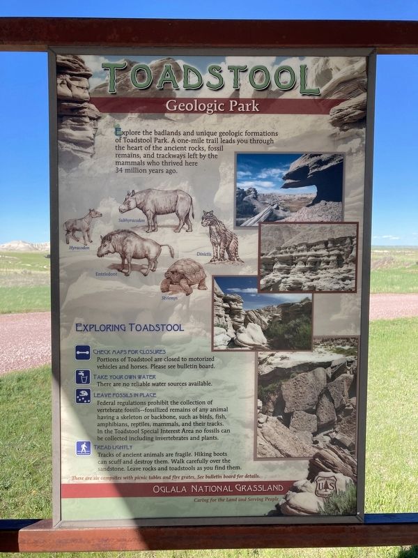
Toadstool
Geologic Park
Exploring Toadstool
Check Maps For Closures
Portions of Toadstool are closed to motorized vehicles and horses. Please see bulletin board.
Take Your Own Water
There are no reliable water sources available.
Leave Fossils In Place
Federal regulations prohibit the collection of vertebrate fossils--fossilized remains of any animal having a skeleton or backbone, such as birds, fish, amphibians, reptiles, mammals, and their tracks. In the Toadstool Special Interest Area no fossils can be collected including invertebrates and plants.
Tread Lightly
Tracks of ancient animals are fragile. Hiking boots can scuff and destroy them. Walk carefully over the sandstone. Leave rocks and toadstools as you find them.
Captions:
Subhyracodon
Hyracodon
Dinictis
Enteledont
Stylemys
There are six campsites with picnic tables and fire grates. See bulletin board for details.
Caring for the Land and Serving People
Erected by US Forest Service, Department of Agriculture.
Topics. This historical marker is listed in these topic lists: Environment • Paleontology.
Location. 42° 51.477′ N, 103° 35.045′ W. Marker is near Crawford, Nebraska, in Dawes County. Marker can be reached from Forest Road 90 west of Toadstool Road. Touch for map. Marker is in this post office area: Crawford NE 69339, United States of America. Touch for directions.
Other nearby markers. At least 8 other markers are within 15 miles of this marker, measured as the crow flies. Landscape in Layers (here, next to this marker); Grassroots (here, next to this marker); Africa in Nebraska (here, next to this marker); The Innovation of Early Homesteaders (about 400 feet away, measured in a direct line); Yellow Hand Monument (approx. 8.6 miles away); Battle of Warbonnet Creek Monument (approx. 8.8 miles away); Fighting in the Buttes (approx. 13.7 miles away); Officers’ Row, 1909 (approx. 14.1 miles away). Touch for a list and map of all markers in Crawford.
Credits. This page was last revised on November 15, 2021. It was originally submitted on November 13, 2021, by Connor Olson of Kewaskum, Wisconsin. This page has been viewed 116 times since then and 12 times this year. Photos: 1, 2. submitted on November 13, 2021, by Connor Olson of Kewaskum, Wisconsin. • J. Makali Bruton was the editor who published this page.

