Auburn in Androscoggin County, Maine — The American Northeast (New England)
Auburn, Maine
— The Museum in the Streets —
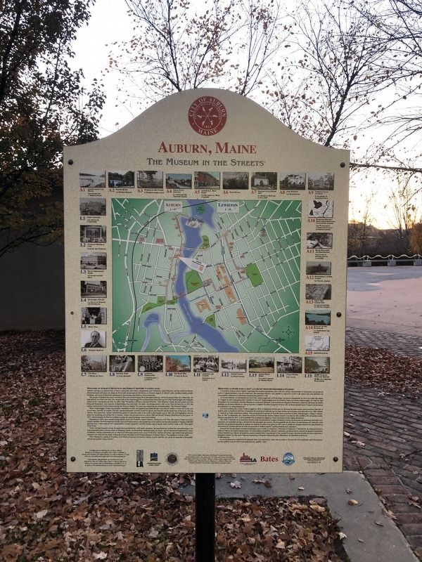
Welcome to Auburn's Museum in the Streets® Historic Walking Tour.
Auburn's history is a manifold tale of Native Americans and settlers; entrepreneurs and visionaries; industrialization and the American Dream. Illustrated panels will guide you along the Riverwalk and through the downtown, to discover snippets of Auburn's past, including notable people, buildings, and events of historical significance in the founding and building of this community.
The people of Auburn have been intricately tied to the Androscoggin River throughout history, which has helped shape the community, the land and the river itself over time. The western side of the Androscoggin River between the Great Falls and the Little Androscoggin was originally settled by the Anasagunticook tribe. In 1684, Chief Warumbee sold land to Richard Wharton. After Wharton's death, the land passed on to the Pejepscot Proprietors. After decades of legal battles over land rights, the claim was incorporated in 1802 as the Town of Danville. In 1842, the eastern section of the Town of Minot became the Town of Auburn. The name was inspired by the Goldsmith poem, "The Deserted Village."
When Androscoggin County was formally established in 1854, the legislature provided that the voters decide whether to locate the county seat in Lewiston, Danville, or Auburn. The bill's sponsor presumed Lewiston would be chosen, but Danville and the towns west of the river voted for Auburn. Five years later, Auburn absorbed the portion of Danville north of the Little Androscoggin, and in 1867, the state legislature voted to annex the remaining area of Danville to Auburn. Auburn was incorporated as a city in 1869 and elected Thomas Littlefield as its first mayor. In 1917, Auburn became the first city in Maine to adopt the council-manager form of government.
Beginning in 1835, shoe manufacturing quickly grew into Auburn's largest industry. During the Civil War, the output of shoes and boots roughly doubled. The following three decades saw a tenfold increase in industry mechanized, peaking at roughly 6,000,000 pairs per year. A labor strike in 1937 caused failure of some companies, and later foreign imports largely ended Auburn's reign as the "shoe capital of the world."
Today, leading economic sectors of employment are healthcare, retail trade, education, and manufacturing. Auburn has taken advantage of its large geographic area to become home to shopping centers, car dealerships, industrial
This walking tour consists of 30 panels, 15 of which are located in downtown Auburn. As you walk this trail, please be respectful of both public and private property. Enjoy the tour!
L'histoire d'Auburn porte d'abord l'empreinte des peuples autochtone puis celle des colons, entrepreneurs et visionaires qui ouvrent la porte à l'industrialisation et au rêve américain. Des panneux illustrés vous guident le long de la rivière et du centre-ville pour présente les personnalitéss, bâtiments et événements marquants du passé de laville.
La vie dest habitants est inimement liée à la rivière Androscoggin qui, au fil du temps, façonne la communauté, la ville et la rivière elle-même. À l'origine, la tribu Anasagnticook s'intalle à l'ouest de l'Androscoggin entre les Grandes Chutes et la Petite Androscoggin. En 1684, le Chef Warumbee vend ce territoire à Richard Wharton et à la mort de Wharton, il est transmis aux Pejepscot Proprietors. Après des décennies de bataille juridique sur les droits fonciers, la vielle de Danville s'y établit. En 1842, le quartier est de la ville de Minot prent le nom d'Auborn, tiré du poème de Goldsmith "Le village abandonné".
Lors de la création du comté d'Androscoggin en 1854, la législature décide que les électeurs devront choisir entre Lewiston, Danville et Auburn pour y installe le chef-lieu. L'iniatuer du projet de loi présume que le choix portera sur Lewiston, mais Danville et le ville établies à l'ouest de la rivière choisiessent Auburn. Cinq ans plus tard le quartier de Danville situé au nord de la Petite Androscoggin s'intègre à Auburn. Puis, en 1867, la législature vote l'annexion du reste de Danville par Auburn. Auburn acquiert son statut de ville en 1869 et élit son premier miare, Thomas Littlefield. En 1917, c'est la première ville du Maine qui adopte le counseil municipal comme organe décisionnel.
Dès 1835, líndustrie de la chaussure devient l'activité principal d'Auburn. Pendant la Guerre de Sécession la production de botte et de chaussures est multipliée par deux. Pendan les trois décennies qui suivent, elle est multipliée par dix grâce à la mécanisation de l'industrie, pour atteindre une production annuelle de quelque six millions de paires. Une grève en 1937 cause la faillite de certaines usines et les importations en provenance de l'étrange mettent un terme au monopole d'Auburn comme "capitale mondiale de la chaussure".
Aujourd'hui, les principaux secteurs économiques sont la santé, le commerce, l'éducation et l'industrie. L'étendue de son territoris perme à Auburn d'abrite des centre commerciaux, de concession automobiles, de parcs industriels, un aéroport et un terminal de transport intermodal. Auburn bénéficie par ailleurs de nombreux espaces naturels dan l'enceinte de la ville: accès à la rivière, activités de plain air, terre agricole et patrimoine naturel. La ville abrite vingt sites figurant sur le Registre National de Sits Historique. Se population avoisine les 23 000 habitants.
Le circuit proposé se compose de 30 panneaux dont 15 se trovent au centre-ville de Auburn. Au cours de votre randonnée, merci de respecter les lieux publics et privés. Nou vous souhaiton un agréable visite!
Erected 2019 by The Museum in the Streets. (Marker Number Map.)
Topics and series. This historical marker is listed in these topic lists: Colonial Era • Industry & Commerce • Native Americans • Settlements & Settlers. In addition, it is included in the The Museum in the Streets®: Auburn-Lewiston, Maine series list. A significant historical year for this entry is 1684.
Location. 44° 5.797′ N, 70° 13.497′ W. Marker is in Auburn, Maine, in Androscoggin County. Marker is on Main Street (Maine Route 136) 0.1 miles south of Court Street (U.S. 202), on the right when traveling north. Touch for map. Marker is at or near this postal address: 95 Main Street, Auburn ME 04210, United States of America. Touch for directions.
Other nearby markers. At least 8 other markers are within walking distance of this marker. Festival Plaza (a few steps from this marker); Auburn's Agriculture, Forestry and Resource Protection Zone (within shouting distance of this marker); Auburn L.L. Bean Store / Le Magasin L.L. Bean À Auburn (within shouting distance of this marker); Roak Block (about 300 feet away, measured in a direct line); Ecology of the Riverbanks / La Biodiversité des Berges (about 500 feet away); Civil War Memorial (about 500 feet away); Maine's Loss of Farmland & Rise of Small Farms (about 700 feet away); Amitgonpontook (about 700 feet away). Touch for a list and map of all markers in Auburn.
Related marker. Click here for another marker that is related to this marker. These signs are identical but stand several blocks away from each other. Both have been included in the database to include a full inventory.
Credits. This page was last revised on September 12, 2023. It was originally submitted on November 16, 2021, by Devry Becker Jones of Washington, District of Columbia. This page has been viewed 470 times since then and 47 times this year. Photos: 1, 2. submitted on November 16, 2021, by Devry Becker Jones of Washington, District of Columbia.
Editor’s want-list for this marker. Clearer photo of the marker • Can you help?

