Near Fort Miller in Washington County, New York — The American Northeast (Mid-Atlantic)
Lakes to Locks Passage
The Great Northeast Journey
— Champlain Canal Region —
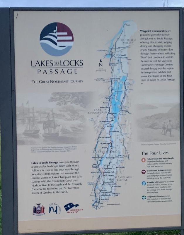
Lakes to Locks Passage takes you through a spectacular landscape laden with history,. Follow this map to find your way through four story-filled regions that connect the historic waters of Lake Champlain and Lake George with the Champlain Canal and Hudson River to the south and Chambly Canal to the Richelieu and St. Lawrence Rivers of Quebec to the north.
Waypoint Communities are poised to greet the traveler along the Lakes to Locks Passage, offering sites to visit, lodging, dining, and shopping experiences, Streams of history flow through these valleys , reflecting "lives" that continue to unfold. Be sure to visit the Waypoint Community Heritage Centers located throughout the region for interpretive exhibits that reveal the stories of the four Lives of the Lakes to Locks Passage.
The Four Lives
- Natural Forces and Native Peoples shaped the landscape and culture of the inland waterways rich with resources.
- Conflict and Settlement traces the exploration, warfare and peacekeeping activities of nation-building along the waterway.
Corridor of Commerce explores the trade in furs, timber, stone, minerals, farm products, and technology that flows through these villages.
-Magnet for Tourism reveals the evolution of tourism and stewardship of the environment
THE SECOND LIFE:
Conflict and Settlement
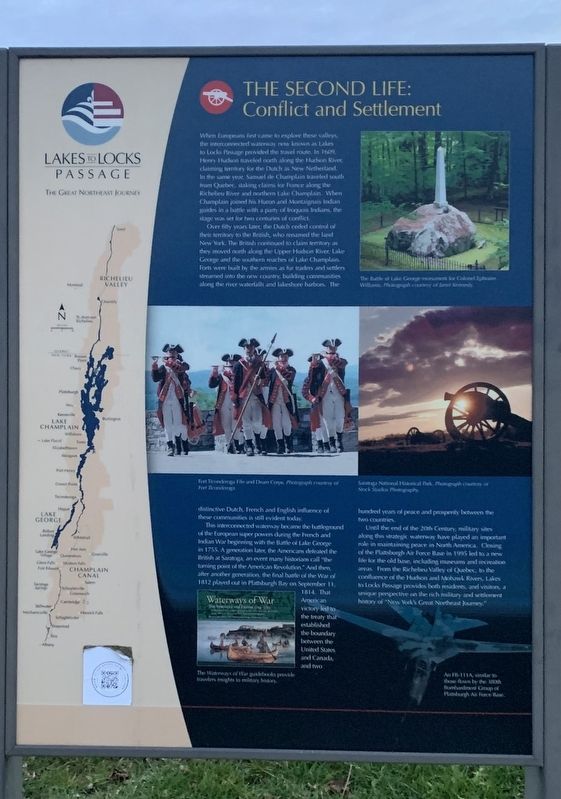
When Europeans first came to explore these valleys, the interconnected waterway now known as the Lakes to Locks Passage provided the travel route. In 1609, Henry Hudson traveled north along the Hudson River, claiming territory for the Dutch as New Netherland. In the same year, Samuel de Champlain traveled south from Quebec, staking claims tor France along the Richelieu River and northern Lake Champlain. When Champlain joined his Huron and Montaignais Indian guides in a battle with a party of Iroquois Indians, the stage was set for two centuries of conflict.
Over fifty years later, the Dutch ceded control of their territory to the British, who renamed the land New York. The British continued to claim territory as they moved north along the Upper Hudson River, Lake George and the southern reaches of Lake Champlain. Forts were built by the armies as fur traders and settlers streamed into the new country, building communities along the river waterfalls and lakeshore harbors. The distinctive Dutch, French and English influence of these communities is still evident today.
(Photos and images:)
The Battle of Lake George Monument for Colonel Ephraim Williams Photograph courtesy of Janet Kennedy
Fort Ticonderoga Fife and Drum Corps. Photograph courtesy of Fort Ticonderoga
Saratoga National Historical Park. Photograph courtesy of Stock Studios Photography
This interconnected waterway became the battleground of the European super powers during the French and Indian War beginning with the Battle of Lake George in 1755. A generation later, the Americans defeated the British at Saratoga, an event many historians call "the turning point of the American Revolution.” And then, after another generation, the final battle of the War of 1812 played out in Plattsburgh Bay on September 11, 1814. That American victory led to the treaty that established the boundary between the United States and Canada, and two hundred years of peace and prosperity between the two countries.
Until the end of the 20th Century, military sites along this strategic waterway have played an important role in maintaining peace in North America, Closing of the Plattsburgh Air Force Base in 1995 led to a new life for the old base, including museums and recreation areas. From the Richelieu Valley of Quebec, to the confluence of the Hudson and Mohawk Rivers, Lakes to Locks Passage provides both residents, and visitors, a unique perspective on the rich military and settlement history of "New York's Great Northeast Journey"
(photos:)
The Waterways of War guidebook provide travelers insights to military history.
A FB-111A, similar to those flown by the 380th Bombardment Group of Plattsburgh Air Force Base.
Road to the Battle of Bennington:
Fort Miller
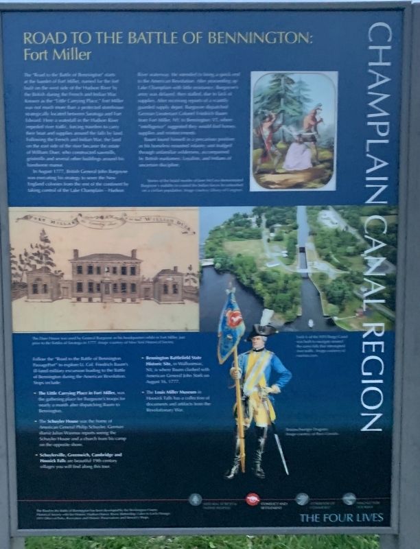
The "Road to the Battle of Bennington" starts at the hamlet of Fort Miller, named for the the fort built on the west side of the Hudson River by the British during the French and Indian War. Known as the "Little Carrying Place" Fort Miller was not much more than a protected storehouse strategically located between Saratoga and Fort Edward. Here a waterfall in the Hudson River impeded river traffic, forcing travelers to carry their boat and supplies around the the falls by land. Following the French and Indian War, the land on the east side of the river became the estate of William Duer, who constructed sawmills, gristmills, and several other buildings around his handsome manor.
In August 1777, British General John Burgonye was executing his strategy to sever New England colonies from the the rest of the continent by taking control of the Lake Champlain -Hudson River waterway. He intended to bring a quick end to the American Revolution. After proceeding up Lake Champlain with little resistance, Burgonye's army was delayed, then stalled, due to lack of supplies. After receiving reports of a scantily guarded supply depot, Burgonye dispatched German Lieutenant Colonel Friedrich Baum from Fort Miller, N.Y. to Bennington, VT where "intelligence" suggested they would find horses, supplies and reinforcements.
Baum found himself in a precarious position as his horseless mounted infantry unit trudged through unfamiliar wilderness, accompanied by British marksmen, Loyalists, and Indians of uncertain discipline.
(photos:)
Stories of the Brutal murder of Jane McCrea demonstrated Burgoyne's inability to control the Indian forces he unleashed on a civilian population. Image courtesy Library of Congress
Lock 6 of the NYS Barge Canal was built to navigate around the same falls that interrupted river traffic. Image courtesy of marineus.com
Braunschweiger Dragoon. Image courtesy of Parcs Canada
The Duer House was used by General Burgonye as his headquarters while in Fort Miller, just prior to the Battle of Saratoga in 1777. Image courtesy of New York Historical Society.
Follow the "Road to the Battle of Bennington Passage Port" to explore Lt. Col. Friedrich Baum's ill-fated military excursion during the American Revolution. Stops include:
- The Little Carrying Place in Fort Miller, was the gathering place for Burgonye's troops for nearly a month after dispatching Baum to Bennington.
The Schuyler House was the house of American General Philip Schuyler. German diarist Julius Wasmus reports seeing the Schuyler House and a church from his camp on the opposite shore.
- Schuylerville, Greenwich, Cambridge, and Hoosick Falls are beautiful 19th century villages you will along this tour.
- Bennington Battlefield State Historic Site, in Walloonsac, NY is where Baum clashed with American General John Stark on August 16, 1777.
-The Louis Miller Museum in Hoosick Falls has a collection of documents and artifacts from the Revolutionary War.
Erected by New York State, NY Scenic Byways, America's Byways.
Topics. This historical marker is listed in these topic lists: Colonial Era • War of 1812 • War, US Revolutionary • Waterways & Vessels. A significant historical date for this entry is September 11, 1609.
Location. 43° 10.185′ N, 73° 34.709′ W. Marker is near Fort Miller, New York, in Washington County. Marker is on U.S. 4, one mile north of Fort Miller Road (County Route 46), on the right when traveling north. Touch for map. Marker is in this post office area: Fort Edward NY 12828, United States of America. Touch for directions.
Other nearby markers. At least 8 other markers are within 2 miles of this marker, measured as the crow flies. Duer House (approx. half a mile away); Judge William Duer (approx. 0.6 miles away); Gen. Henry Knox Trail (approx. 0.6 miles away); Fort Miller (approx. 0.6 miles away); Five Porch Farm (approx. 0.7 miles away); a different marker also named Fort Miller (approx. ¾ mile away); Gen. Washington (approx. 1.8 miles away); Gen. Schuyler's Intrenchments (approx. 1.9 miles away).
Credits. This page was last revised on November 17, 2021. It was originally submitted on November 16, 2021, by Steve Stoessel of Niskayuna, New York. This page has been viewed 185 times since then and 28 times this year. Photos: 1, 2, 3, 4. submitted on November 16, 2021, by Steve Stoessel of Niskayuna, New York. • Bill Pfingsten was the editor who published this page.


