Waterfront District in Portland in Cumberland County, Maine — The American Northeast (New England)
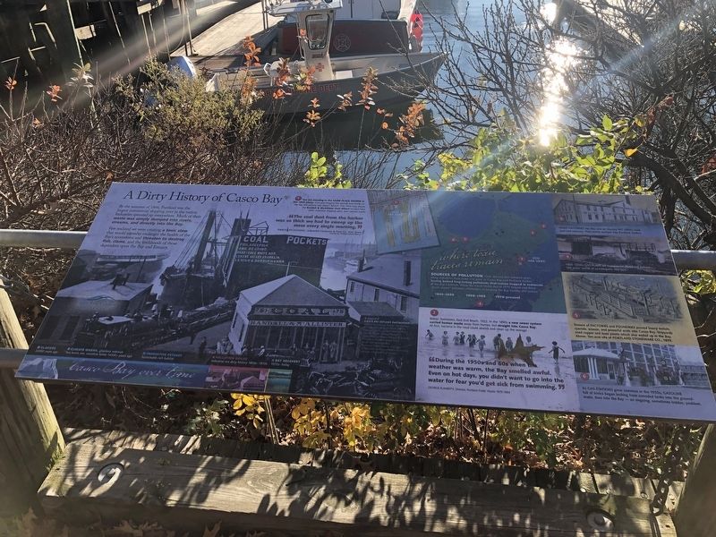
A Dirty History of Casco Bay
By the summer of 1866, Portland was the largest commercial shipping port in the nation. Industries sprouted up everywhere. Much of their was simply dumpted into rivers, streams, and directly into the Bay.
Few realized that we were creating a toxic stew that would someday endanger the health of the Bay's ecosystems and threaten to destroy fish, clams, and the lifelihoods of those dependent upon the Bay and Estuary.
"The coal dust from the harbor was so thick we had to sweep up the mess every single morning."
Randolph Dominic, Sulkowitch Hardware & Paint Co. Fore Street
"During the 1950s and 60s when the weather was warm, the Bay smelled awful. Even on hot days, you didn't want to go into the water for fear you'd get sick from swimming."
George Flaherty, Director Portland Public Works 1975-1994
Where Toxic Traces Remain
Sources of pollution Over the last few hundred years, many industries have come and gone in Casco Bay and Portland Harbor, leaving behind long-lasting pollutants that remain trapped in sediments at the Bay's bottom. While the Clean Water Act of 1972 helped end these "point source" pollutors, challenges to keeping the Bay healthy still remain.
1. You are standing in the same place shown in this 1900 photo. Can you imagine the sounds and smells on the day this picture was taken? Right: This 1914 map shows the Randall & McAllister Coal Wharf located here, other industrial shipping piers, and railroad tracks.
2. Below: Swimmers, East End Beach, 1922. In the 1890s a new sewer system carried human waste away from homes, but straight into Casco Bay. At first, bacteria in the mud could absorb and clean up the sewage.
3. Paint factories like this one on Munjoy Hill (1899) used lead and mercury. Their waste washed into Portland Harbor.
4. 1956: Coal-gas plant on Commercial Street left behind 100 years' worth of carcinogenic coal tars.
5. Dozens of factories and foundries poured heavy metals, cyanide, arsenic, and powerful acids into Casco Bay. Shipyards used copper and toxic paints which also ended up in the Bay. Above: Ten-acre site of Portland Stoneware Co., 1899.
6. As gas stations grew common in the 1950s, gasoline full of toxics began leaking from corroded tanks into the groundwater, then into the Bay — an ongoing, sometimes hidden, problem.
Casco Bay over time
• Glaciers 22000 yearsago
• Climate warms, glaciers retreat Sea levels rise, coastline forms 14500+ years ago
• Productive estuary Sustainable rich habitat
• Pollution builds Industrial era dirty hisotry 1850s - 1970s
• Bay Recovery 1970s - today
Erected by Casco Bay Estuary Partnership.
Topics. This historical marker is listed in these topic lists: Animals • Environment • Industry & Commerce • Waterways & Vessels. A significant historical year for this entry is 1866.
Location. 43° 39.448′ N, 70° 14.986′ W. Marker is in Portland, Maine, in Cumberland County. It is in the Waterfront District. Marker is on Commercial Street (U.S. 1A) just south of Franklin Street (U.S. 1A), on the left when traveling south. Touch for map. Marker is at or near this postal address: 54 Commercial St, Portland ME 04101, United States of America. Touch for directions.
Other nearby markers. At least 8 other markers are within walking distance of this marker. Casco Bay's four thousand years of sustainable, stable productivity (here, next to this marker); Today, you see a healthier Casco Bay / Take a closer look (here, next to this marker); Franklin Street Wharf (about 300 feet away, measured in a direct line); India Street Terminal (approx. 0.2 miles away); The Site of Fort Loyal (approx. 0.2 miles away); Mariner's Church (approx. 0.2 miles away); Hack Stand of Charles H.L. Pierre (approx. 0.2 miles away); Secondhand Clothing Store of Lloyd Scott (approx. 0.2 miles away). Touch for a list and map of all markers in Portland.
Credits. This page was last revised on February 13, 2023. It was originally submitted on November 21, 2021, by Devry Becker Jones of Washington, District of Columbia. This page has been viewed 225 times since then and 60 times this year. Photos: 1, 2. submitted on November 21, 2021, by Devry Becker Jones of Washington, District of Columbia.

