Urbanna in Middlesex County, Virginia — The American South (Mid-Atlantic)
History of the Waterman
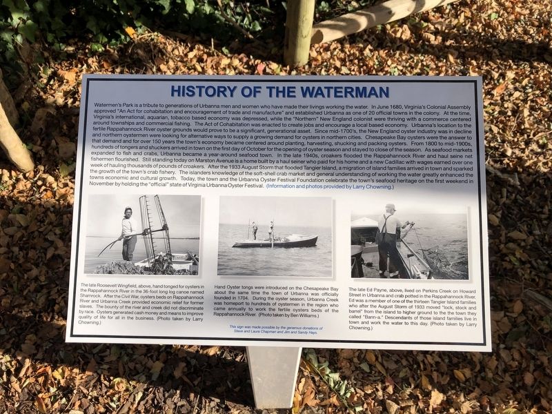
Watermen's Park is a tribute to generations of Urbanna men and women who have made their livings working the water. In June 1680, Virginia's Colonial Assembly approved "An Act for cohabitation and encouragement of trade and manufacture" and established Urbanna as one of 20 official towns in the colony. At the time, Virginia's international, aquarian, tobacco based economy was depressed, while the "Northern" New England colonists were thriving with with a commerce centered around townships and commercial shipping. The Act of Cohabitation was enacted to create jobs and encouraged a local based economy. Urbanna's location to the fertile Rappahannock River oyster grounds would prove to be a significant, generational asset. Since mid-1700's, the New England oyster industry was in decline and northern oystermen were looking for alternative ways to supply a growing demand for oysters in northern cities. Chesapeake Bay oysters were the answer to that demand and for over 150 years the town's economy became centered around planting, harvesting, shucking and packing oysters. From 1800 to mid-1900s, hundreds of tongers and suhuckers
this page online
[Captions:]
The late Roosevelt Wingfield, above, hand tongued for oysters in the Rappahannock River
Hand Oyster tongs were introduced on the Chesapeake Bay about the same time the town of Urbanna was officially founded in 1704. During the oyster season, Urbanna Creek was homeport to hundreds of oystermen in the region who came annually to work the fertile oysters beds of the Rappahannock River. (Photo taken by Ben Williams.)
The late Ed Payne, above, lived on Perkins Creek on Howard Street in Urbanna and crab potted in the Rappahannock River. Ed was a member of one of the thirteen Tangier Island families who after the August Storm of 1933 moved "lock, stock and barrel" from the island to higher ground to the town they called "Bann-a." Descendants of those island families live in town and work the water to this day. (Photo taken by Larry Chowning.)
Erected by Steve and Laura Chapman and Jim and Sandy Hays.
Topics. This historical marker is listed in these topic lists: African Americans • Animals • Industry & Commerce • Waterways & Vessels. A significant historical month for this entry is June 1680.
Location. 37° 38.623′ N, 76° 34.254′ W. Marker is in Urbanna, Virginia, in Middlesex County. It is on Kent Street (County Road T-1014) just south of Colorado Avenue (County Road T-1008), on the right when traveling north. Touch for map. Marker is at or near this postal address: 185 Kent St, Urbanna VA 23175, United States of America. Touch for directions.

Regionally, this marker is on the Middle Peninsula. It is also in the American South, specifically in the Upper South, in the Tidewater, in the Chesapeake Bay Region, and on the Eastern Seaboard. Globally, it is in the North Atlantic Region, North America, the Western Hemisphere, the Western World, and the Anglosphere. Historically, it finds itself in what was once the territory of the Mississippian Culture, one of the original Thirteen Colonies, one of the Confederate States of America, and the Antebellum South.
Other nearby markers. At least 8 other markers are within walking distance of this marker: Smith’s Snapshot (approx. 0.4 miles away); Civil War (approx. 0.4 miles away); Oysters (approx. half a mile away); Prettyman’s Rolling Road (approx. half a mile away); John Mitchell’s Map (approx. half a mile away); Tobacco Road (approx. half a mile away); Urbanna Museum & Visitors Center (approx. half a mile away); A Hub For Commerce (approx. half a mile away). Touch for a list and map of all markers in Urbanna.
Additional keywords. 🦪
Credits. This page was last revised on November 25, 2021. It was originally submitted on November 25, 2021, by Devry Becker Jones of Washington, District of Columbia. This page has been viewed 511 times since then and 35 times this year. Photos: 1, 2. submitted on November 25, 2021, by Devry Becker Jones of Washington, District of Columbia.
