Old Town West in Alexandria, Virginia — The American South (Mid-Atlantic)
The Civil War & Archaeology of the Block
City of Alexandria, Est. 1749

Photographed By Devry Becker Jones (CC0), December 24, 2021
1. The Civil War & Archaeology of the Block Marker
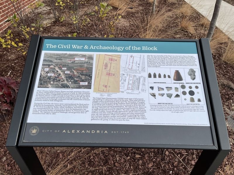
About 100 years before Ramsey Homes was built, prominent Alexandrian Henry Daingerfield purchased this parcel of land. In 1849, prominent Alexandrian Henry Daingerfield purchased a parcel of land upon which the Ramsey Homes would eventually be built. Prior to the sale, the block was primarily unoccupied and used for market gardening. By 1854, the property became increasingly residential with the construction of houses primarily rented to Irish immigrants.
The United States Quartermaster (USQM) made maps of all property and buildings in Alexandria utilized by the army. These maps provide a valuable source of information about Civil War Alexandria. A hospital building is centrally located along Pendleton Street and likely specifically served the men of Battery H who were too injured or ill for duty but not in need of more formal hospitalization. The sutler's house, shown on the map, referred to the civilian merchant licensed by the U.S. military to supply goods and services to soldiers. The sutler supplemented goods issued to a soldier. Goods officially approved for sale by sutlers included: uniforms and other clothing; toiletries; games and other amusements; pens, ink, and stationery; books and newspapers; mending kits; dishes and cookware; blankets; candles; and matches. Additionally, the sutler's shop also frequently became the social center of camp life where soldiers gathered to eat, gossip, or otherwise pass the time.
After the war, ownership of the block was returned to Henry Daingerfield, who died shortly thereafter. The property changed hands multiple times over the years though it remained primarily empty. During the early 20th century, housing in the vicinity appears to have been somewhat integrated as new residents were attracted by employment opportunities, for both blacks and whites, associated with the railroad and industrial development. By the 1930s, the same area was home to a diverse population of African Americans and both recent and descendant German and Italian immigrants.
[Caption:]
Archaeological Findings: In 2016, Thunderbird Archeology conducted intensive archeological investigations on the block bounded by Wythe, Alfred, Pendleton, and Patrick Streets. Artifacts

Photographed By Devry Becker Jones (CC0), December 24, 2021
2. The Civil War & Archaeology of the Block Marker
Erected by City of Alexandria, Virginia.
Topics and series. This historical marker is listed in these topic lists: African Americans • Anthropology & Archaeology • Industry & Commerce • Settlements & Settlers • War, US Civil. In addition, it is included in the Virginia, The City of Alexandria series list. A significant historical year for this entry is 1849.
Location. 38° 48.689′ N, 77° 2.934′ W. Marker is in Alexandria, Virginia. It is in Old Town West. Marker is on North Patrick Street (U.S. 1) just north of Pendleton Street, on the right when traveling north. Touch for map. Marker is at or near this postal address: 605 N Patrick St, Alexandria VA 22314, United States of America. Touch for directions.
Other nearby markers. At least 8 other markers are within walking distance of this marker. Ramsey Homes (about 300 feet away, measured in a direct line); Alexandria Black History Museum (about 300 feet away); Robert Robinson Library 1940 (about 400 feet away); The First Parker-Gray School (about 400 feet away); The Memorial Pool (about 500 feet away); The Student-Athletes of Parker-Gray High School (about 600 feet away); Colross-Alexandria's Urban Phoenix (about 600 feet away); Alexandria and Fredericksburg Railroad (about 700 feet away). Touch for a list and map of all markers in Alexandria.
Credits. This page was last revised on January 27, 2023. It was originally submitted on December 24, 2021, by Devry Becker Jones of Washington, District of Columbia. This page has been viewed 419 times since then and 16 times this year. Photos: 1, 2. submitted on December 24, 2021, by Devry Becker Jones of Washington, District of Columbia.