Fort Wetherill State Park in Jamestown in Newport County, Rhode Island — The American Northeast (New England)
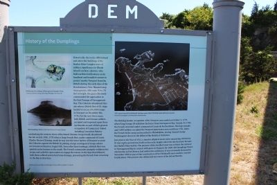
History of the Dumplings
Historically, the rocky cliffs behind and above the buildings of the Harbor Mine Complex were of military significance to Rhode Island's earliest colonists, who built earthen fortifications on its headland and installed cannon to protect nearby Newport from the British during the Revolutionary War. Situated atop steep granite cliffs some 50-70 feet in height, the guns effectively commanded the approaches to the East Passage of Narragansett Bay. The Colonists abandoned this site when a British fleet of 81 ships landed in excess of 6,000 troops in Newport on December 8th, 1776. For the next three years both British and Hessian soldiers occupied and improved upon these earthworks as part of their general occupation of Conancicut Island, including Conanicut Battery overlooking the western shore of the island. Hessian troops briefly abandoned the site on July 29th, 1778 when a large French fleet, under command of Comte Charles Hector d'Estaing, made its way into the inner harbor of Newport to assist the Colonists against the British by putting a large contingent of troops ashore on Conanicut island on August 8th. Soon after these landings, a British fleet was spotted on the horizon to the south. The French commander promptly withdrew his troops and sailed for open waters to engage the enemy. In the days that followed, both fleets suffered severe hurricane damage. preventing the French from returning to the Bay at that time.
The British-Hessian occupation of the Newport area ended on October 5, 1779, when King George III withdrew his forces from Narragansett Bay. On July 10, 1780, the French returned under command of Comte de Rochambeau. His large armada and 5,800 soldiers occupied the Newport-Jamestown area until June 1781, when the French broke camp and marched to Philadelphia, joining General George Washington's forces in the defeat of the British at Yorktown.
Just prior to the War of 1812, a massive elliptical stone tower measuring 180 feet by 81 feet on the ground was built on the rocky heights above the site that later became the Harbor Mine facility. The purpose of this fortified tower was to block the entrance to Narragansett Bay in concert with guns in Newport. By 1820, the Dumpling tower, also known as Fort Brown, had outlived its usefulness. It was eventually destroyed in November 1898 as part of the construction of Fort Wetherill's more modern concrete fortifications. This process also obliterated any traces of old earthworks.
Topics. This historical marker is listed in these topic lists: Colonial Era • Forts and Castles • War, US Revolutionary. A significant historical month for this entry is June 1781.
Location. 41° 28.726′ N, 71° 21.455′
W. Marker is in Jamestown, Rhode Island, in Newport County. It is in Fort Wetherill State Park. Marker is on Fort Wetherill Road, on the right when traveling east. The marker is in front of the third building at the end of the road on the left. Touch for map. Marker is in this post office area: Jamestown RI 02835, United States of America. Touch for directions.
Other nearby markers. At least 8 other markers are within one mile of this marker, measured as the crow flies. Harbor Mine (Torpedo) Complex (a few steps from this marker); Fort Wetherill (within shouting distance of this marker); U.S.S. Bennington CVA-20 (approx. ¾ mile away); John Adams (approx. 0.8 miles away); Southwest Battery (approx. one mile away); Between the Wars (approx. one mile away); Changing Role of the Fort (approx. one mile away); Three Tiers of Firepower (approx. one mile away). Touch for a list and map of all markers in Jamestown.
More about this marker. "part of their general occupation of Conancicut Island" has extra "c" in what otherwise would be "Conanicut".
Regarding History of the Dumplings. The fort depicted on the upper left is shown on what is now called Bull Point.
Fort Dumpling, the stone tower in the photograph on the marker, was on the next promontory to the west. The marker is placed between these two promontories, closer to Fort Dumpling.
Credits. This page was last revised on March 10, 2024. It was originally submitted on June 22, 2012, by Bryan Simmons of Attleboro, Massachusetts. This page has been viewed 1,242 times since then and 100 times this year. Last updated on March 8, 2024, by Sandy Sorlien of Jamestown, Rhode Island. Photos: 1, 2. submitted on June 22, 2012, by Bryan Simmons of Attleboro, Massachusetts. • Devry Becker Jones was the editor who published this page.

