Melrose in Paulding County, Ohio — The American Midwest (Great Lakes)
Fort Brown
Inscription.
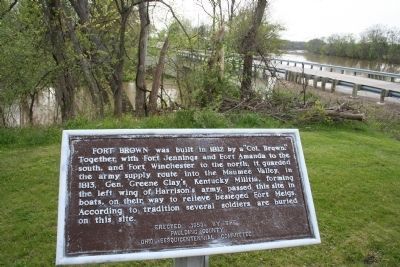
Fort Brown was built in 1812 by a "Col. Brown." Together with Fort Jennings and Fort Amanda to the south, and Fort Winchester to the north, it guarded the army supply route into the Maumee Valley. In 1813, Gen. Greene Clay's Kentucky Militia, forming the left wing of Harrison's army, passed this site in boats, on their way to relieve besieged Fort Meigs. According to tradition several soldiers are buried on this site.
Erected 1953 by Paulding County Ohio Sesquicentennial Committee.
Topics and series. This historical marker is listed in these topic lists: Forts and Castles • Military • Native Americans • War of 1812. In addition, it is included in the Former U.S. Presidents: #09 William Henry Harrison series list. A significant historical year for this entry is 1812.
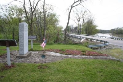
Location. 41° 6.699′ N, 84° 24.881′ W. Marker is in Melrose, Ohio, in Paulding County. Marker is on County Road 171, 0.2 miles south of County Road 177, on the left when traveling north. This Historical marker is located south of Defiance, Ohio, in a remote area of rural Paulding County, Ohio, on the west side of the Auglaize River, just to the south of where the Little Auglaize River flows into the Auglaize River. Touch for map. Marker is in this post office area: Melrose OH 45861, United States of America. Touch for directions.
Other nearby markers. At least 8 other markers are within 8 miles of this marker, measured as the crow flies. Site of Fort Brown (here, next to this marker); The Indians (here, next to this marker); Charloe (approx. 1.7 miles away); Imaginary Likeness Of Chief Charloe Peter (approx. 1.7 miles away); Charloe Community Park (approx. 1.7 miles away); Miami-Erie and Wabash-Erie Canals (approx. 6.1 miles away); Joshua A. Ramsey Memorial (approx. 6.1 miles away); Grover Hill Town Hall Bell (approx. 7.2 miles away). Touch for a list and map of all markers in Melrose.
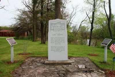
More about this marker. This historical marker shares it's location with two additional historical markers, that all are situated upon the original site of Fort Brown
Regarding Fort Brown. In the "Historical Sketch - Paulding County, Ohio," when discussing the early military history of the county, it states the following: "It was first traversed by Americans under Gen. 'Mad' Anthony Wayne in 1794 enroute to the Battle of Fallen Timbers. During the War of 1812, it was crossed again by Gen. James Winchester, who fought a running battle across Emerald Twp. with the British and Indians. Also in 1812, Ft. Brown was built at the confluence of the Big and Little Auglaize Rivers by a detachment of Gen. Wm. Henry Harrison under Colonel Samuel Wells."
When looking at the bigger
picture, when General Harrison was conducting his military operations in the Northwest, attempting to take back Detroit, invade Canada, and defeat the western British army and its Indian allies, he decided that with the logistical problems of moving his army through the hostile environment of the Great Black Swamp in northwestern Ohio, he would need to divide his army into three separate wings. The right wing would move up the Sandusky River Valley, the center wing would follow the mlitary road made by General Hull''s army, and the left wing would move up the Auglaize-Maumee River valleys. On his left wing General Harrison ordered a road to be built which would ultimately connect Piqua to Fort Defiance. Much of the road ended up being built along the western bank of the Auglaize River (and from Fort Amanda northward the Auglaize river was a navigable transportation route used extensively by the military). To protect his left wing's lines of supply and communication, General Harrison ordered several forts to be built from Piqua, Ohio to Fort Defiance. These forts ended up being, Fort Barbee (at modern day St. Mary's, Ohio), Fort Amanda (just outside of Spencerville, Ohio, situated at the head of navigation on the Auglaize River), Fort Jennings, and Fort Brown (situated just south of Fort Defiance, Ohio, at the confluence of the Little Auglaize River with the Auglaize River,
Credits. This page was last revised on June 16, 2016. It was originally submitted on May 14, 2009, by Dale K. Benington of Toledo, Ohio. This page has been viewed 3,536 times since then and 98 times this year. Photos: 1, 2, 3. submitted on May 14, 2009, by Dale K. Benington of Toledo, Ohio. • Syd Whittle was the editor who published this page.


