Ocracoke in Hyde County, North Carolina — The American South (South Atlantic)
Fort Ocracoke
Photographed by Tom Bosse, September 20, 2021
1. Fort Ocracoke Marker
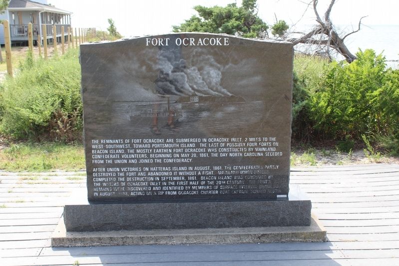
Fort Ocracoke
The remnants of Fort Ocracoke are submerged in Ocracoke Inlet, 2 miles to the west – southwest, toward Portsmouth Inlet. The last of possibly four forts on Beacon Island, the mostly earthen Fort Ocracoke was constructed by mainland Confederate volunteers, beginning on May 20, 1861, the day North Carolina seceded from the Union and joined the Confederacy.
After Union victories on Hatteras Island in August, 1861, the Confederates partly destroyed the fort and abandoned it without a fight. Mainland Union forces completed the destruction in September, 1861. Beacon Island was consumed by the waters of Ocracoke Inlet in the first half of the 20th century. The fort’s remains were discovered and identified by members of surface interval diving boats in August 1998, acting on a tip from Ocracoke Charter Boat Captain, Donald Austin.
(rear)
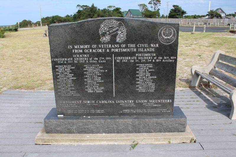
In Memory of Veterans of the Civil War from Ocracoke & Portsmouth Islands
Ocracoke
Confederate Soldiers of the 17th, 19th, 32nd, & 33rd NC INF & Other Units
Holloway Balance • William R. Balance • William B. Bragg • Fabius F. Dailey • Isaac L. Farrow • Wilson
this page online
Portsmouth
Confederate Soldiers of the 36th, 40th, NC INF, the 1st, 2nd, 3rd, & 10th Artillery
Zephiniah Burgess • Anthony Dennis • William Dixon • George W. Gaskill • William H. Hill • Edward Mayo • Edward D. Mayo • William R. Roberson • David W. Roberts • John S. Roberts • Samuel C. Roberts • Stephen G. Roberts • Spyers Singleton (Dr.) • Ambrose J. Styron • Christopher T. Styron • William S. Styron
1st Regiment North Carolina Infantry Union Volunteers
Alpheus W. Simpson • John F. O’Neal • Augustus Dudley • James Mason • George W. Jackson – a • # Joseph Lupton • James E. Roberson
*
Photographed by Tom Bosse, September 20, 2021
2. Fort Ocracoke Marker
# Denotes dual service in the United States Navy
+ Denotes dual service in the Confederate States Navy
-a or -b after a name denotes two different people, same name
Erected by Hyde County Heritage Trail.
Topics. This memorial is listed in these topic lists: Forts and Castles • War, US Civil. A significant historical date for this entry is May 20, 1861.
Location. 35° 7.053′ N, 75° 59.175′ W. Memorial is in Ocracoke, North Carolina, in Hyde County. It can be reached from Pilottown Circle north of Irvin Garrish Hwy (State Highway 12), on the right when traveling north. Touch for map. Memorial is in this post office area: Ocracoke NC 27960, United States of America. Touch for directions.

Regionally, this memorial is in the Coastal Plain and on the Outer Banks. It is also in the American South, specifically in the Upper South, in the Tidewater, and on the Eastern Seaboard. Globally, it is in the North Atlantic Region, North America, the Western Hemisphere, the Western World, and the Anglosphere. Historically, it finds itself in what was once the territory of the Mississippian

Photographed by Tom Bosse, September 20, 2021
3. Fort Ocracoke Marker
Other nearby markers. At least 8 other markers are within walking distance of this marker: Harboring Change (about 500 feet away, measured in a direct line); Welcome to picturesque Ocracoke Island… (about 500 feet away); Journey to the original Down East… (about 500 feet away); Welcome to Ocracoke Island (about 500 feet away); Ocracoke’s Commercial Fishing Heritage (about 500 feet away); Late 19th Century Cistern (about 600 feet away); Teach's Hole (about 600 feet away); The Blanche (about 600 feet away). Touch for a list and map of all markers in Ocracoke.
Also see . . . Fort Ocracoke. Ocracoke Navigator website entry (Submitted on January 30, 2022, by Tom Bosse of Jefferson City, Tennessee.)
Credits. This page was last revised on January 31, 2022. It was originally submitted on January 30, 2022, by Tom Bosse of Jefferson City, Tennessee. This page has been viewed 611 times since then and 69 times this year. Photos: 1, 2, 3. submitted on January 30, 2022, by Tom Bosse of Jefferson City, Tennessee. • Bernard Fisher was the editor who published this page.
