Hayes in Gloucester County, Virginia — The American South (Mid-Atlantic)
Persistence
Machicomoco State Park
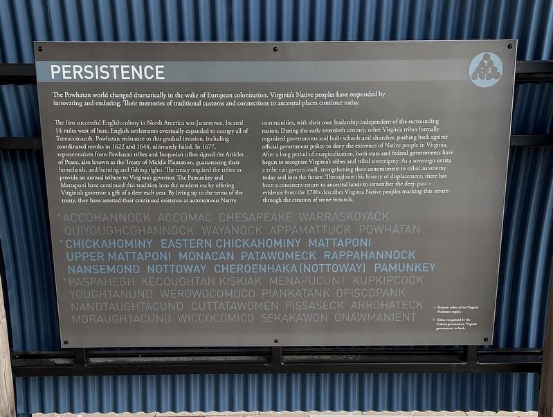
The Powhatan world changed dramatically in the wake of European colonization. Virginia’s Native peoples have responded by innovating and enduring. Their memories of traditional customs and connections to ancestral places continue today.
The first successful English colony in North America was Jamestown, located 14 miles west of here. English settlements eventually expanded to occupy all of Tsenacomacoh. Powhatan resistance to this gradual invasion, including coordinated revolts in 1622 and 1644, ultimately failed. In 1677, representatives from Powhatan tribes and Iroquoian tribes signed the Articles of Peace, also known as the Treaty of Middle Plantation, guaranteeing their homelands, and hunting and fishing rights. The treaty required the tribes to provide an annual tribute to Virginia’s governor. The Pamunkey and Mattaponi have continued this tradition into the modern era by offering Virginia’s governor a gift of a deer each year. By living up to the terms of the treaty, they have asserted their continued existence as autonomous Native communities, with their own leadership independent of the surrounding nation. During the early twentieth century, other Virginia tribes formally organized governments and built schools and churches, pushing back against official government policy to deny the existence of Native people in Virginia. After a long period of marginalization,both state and federal governments have begun to recognize Virginia’s tribes and tribal sovereignty. As a sovereign entity, a tribe can govern itself, strengthening their commitment to tribal autonomy today and into the future. Throughout this history of displacement, there has been a consistent return to ancestral lands to remember the deep past — evidence from the 1700s describes Virginia Native peoples marking this return through the creation of stone mounds.
☆ Accohannock • Accomac • Chesapeake • Warraskoyack • Quiyoughcohannock • Wayanock • Appamattuck • Powhatan
★ Chickahominy • Eastern Chickahominy • Mattaponi • Upper Mattaponi • Monacan • Patawomeck • Rappahannock • Nansemond • Nottoway • Cheroenhaka (Nottoway) • Pamunkey
☆ Paspahegh • Kecoughtan • Kiskiak • Menapucunt • Kupkipcock • Youghtanund • Werowocomoco • Piankatank • Opiscopank • Nandtaughtacund • Cuttatawomen • Pissaseck • Arrohateck • Moraughtacund • Wiccocomico • Sekakawon • Onawmanient
☆ Historic tribes of the Virginia Piedmont region.
★ Tribes recognized by the Federal government, Virginia government, or both.
Erected 2021 by State of Virginia.
Topics. This historical marker is listed in these topic lists: Agriculture • Native Americans • Settlements & Settlers. A significant historical year for this entry is 1622.
Location. 37° 17.887′ N, 76° 32.193′ W. Marker is in Hayes, Virginia, in Gloucester County. Marker can be reached from Timberneck Farm Road, 0.3 miles south of Borden Road, on the right when traveling east. The marker is located on the grounds of Machicomoco State Park. Touch for map. Marker is at or near this postal address: 3084 Timberneck Farm Rd, Hayes VA 23072, United States of America. Touch for directions.
Other nearby markers. At least 8 other markers are within walking distance of this marker. Authority and Ceremony (a few steps from this marker); Peacemaking and Mobility (a few steps from this marker); Managing a Dynamic Landscape (a few steps from this marker); History and Community (a few steps from this marker); The Algonquian Landscape (a few steps from this marker); Timberneck House Renovation at Machicomoco State Park (within shouting distance of this marker); Early Timberneck Graveyard (about 300 feet away, measured in a direct line); Powhatan’s Chimney (approx. half a mile away). Touch for a list and map of all markers in Hayes.
Also see . . .
1. Virginia’s Machicomoco State Park—A “Special Meeting Place”. (Submitted on February 17, 2022, by Brandon D Cross of Flagler Beach, Florida.)
2. Machicomoco State Park. (Submitted on February 17, 2022, by Brandon D Cross of Flagler Beach, Florida.)
Credits. This page was last revised on February 18, 2022. It was originally submitted on February 17, 2022, by Brandon D Cross of Flagler Beach, Florida. This page has been viewed 132 times since then and 12 times this year. Photos: 1, 2. submitted on February 17, 2022, by Brandon D Cross of Flagler Beach, Florida. • Devry Becker Jones was the editor who published this page.

