
Gettysburg in Adams County, Pennsylvania — The American Northeast (Mid-Atlantic)
"…sights and sounds…too horrible to describe…"
Photographed by Craig Swain, April 4, 2009
1. "...sights and sounds...too horrible to describe..." Marker
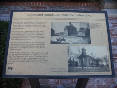
Four years after Gettysburg became the county seat in 1800, the first Adams County Courthouse was placed in Lincoln Square (one block to your right). In 1859 this larger building was erected to serve the growing populace.
The arrival of the Union and Confederate armies in the summer of 1863 forced the courthouse into unconventional uses. On June 26th, Confederate troops temporarily held the town and according to Margaretta Kendelhart, "…Rebels…occupied the Court House during the night…"
Five days later the great battle at Gettysburg began. The carnage created a new role for the courthouse, one of an army hospital. Beginning on July 1st, the grim work of the surgeons continued well after the armies departed.
Fannie Buehler, living opposite the courthouse (at 112), vividly described the scene: "The sights and sounds at the Court House for a week after the battle are too horrible to describe… Limbs were amputated amid the cries and groans of suffering humanity… Loads of arms and legs…were carted outside of town to be burned or buried."
Erected by Main Street Gettysburg. (Marker Number 20.)
Topics and series.
this page online
Location. This marker has been replaced by another marker nearby. It was located near 39° 49.77′ N, 77° 13.875′ W. Marker was in Gettysburg, Pennsylvania, in Adams County. It was at the intersection of Baltimore Street (Business U.S. 15) and West Middle Street, on the right when traveling south on Baltimore Street. Located in front of the courthouse. Touch for map. Marker was at or near this postal address: 111 Baltimore St, Gettysburg PA 17325, United States of America. Touch for directions.

Regionally, this marker was in South-Central Pennsylvania. It was also in the American Northeast, in the Mid-Atlantic, in Appalachia, and specifically in Northern Appalachia. Globally, it was in North America, the Western Hemisphere, the Western World, and the Anglosphere. Historically, it found itself in what was once the Haudenosaunee (Iroquois) Confederacy and also one of the original Thirteen Colonies.

Photographed by Craig Swain, April 4, 2009
2. Marker in Front of the Courthouse
Other nearby markers. At least 8 other markers are within walking distance of this location: Memorial Day Order (here, next to this marker); Adams County Courthouse (here, next to this marker); Manor of Maske (here, next to this marker); Adams County World War Memorial (here, next to this marker); Adams County (a few steps from this marker); Thaddeus Stevens, the Great Commoner, 1792 - 1868 (a few steps from this marker); Gettysburg Compiler Office (within shouting distance of this marker); The Fahnestock House (within shouting distance of this marker). Touch for a list and map of all markers in Gettysburg.
Other markers no longer nearby. Politics and "Penelope" (was within shouting distance of this marker but has been replaced with another marker now near it); "…the busiest scene I ever witnessed…" (was within shouting distance of this marker but has been replaced with another marker now near it).
More about this marker. On the upper right is a drawing of The first courthouse in Lincoln Square. Augustus Kollner sketch looking towards Chambersburg Street, May 1840. Below it is a photo of The second Adams County Courthouse, ca. 1915. The rear "T" section was added in 1909.
Related marker.
Photographed by Craig Swain, April 4, 2009
3. The Courthouse Today

Photographed by Craig Swain, April 4, 2009
4. Markers on the Front of the Courthouse
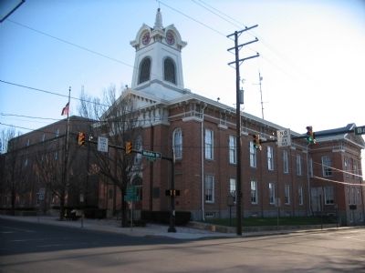
On the southeast face of the courthouse are National Historic Register, Manor of Maske, Grand Army of the Republic, and World War I markers.
Credits. This page was last revised on November 12, 2026. It was originally submitted on May 22, 2009, by Craig Swain of Leesburg, Virginia. This page has been viewed 2,432 times since then and 58 times this year. Photos: 1, 2, 3, 4. submitted on May 22, 2009, by Craig Swain of Leesburg, Virginia.
