Logan Square in Philadelphia in Philadelphia County, Pennsylvania — The American Northeast (Mid-Atlantic)
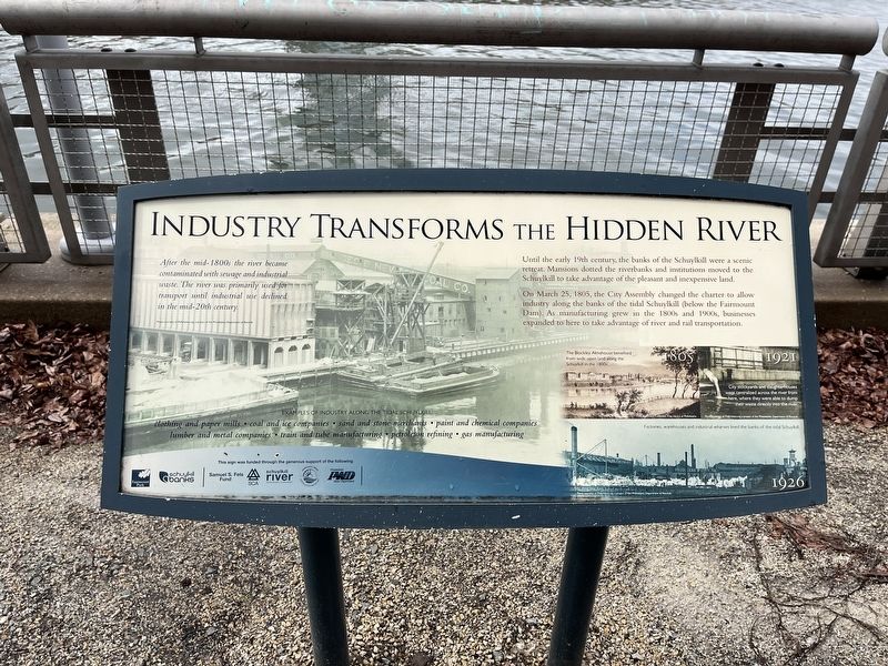
Industry Transforms the Hidden River

Photographed By Devry Becker Jones (CC0), February 25, 2022
1. Industry Transforms the Hidden River Marker
Until the early 19th century, the banks of the Schuylkill were a scenic retreat. Mansions dotted the riverbanks and institutions moved to the Schuylkill to take advantage of the pleasant and inexpensive land.
On March 25, 1805, the City Assembly changed the charter to allow industry along the banks of the tidal Schuylkill (below the Fairmount Dam). As manufacturing in the 1800s and 1900s, businesses expanded to here to take advantage of the river and rail transportation.
[Captions:]
After the mid-1800s the river became contaminated with sewage and industrial waste. The river was primarily used for transport until industrial use declined in the mid-20th century.
Examples of industry along the Schuylkill:
clothing and paper mills • coal and ice companies • sand and stone merchants • paint and chemical companies • lumber and metal companies • train and tube manufacturing • petroleum refining • gas manufacturing
1805: The Blockley Almshouse benefited from wide open land along the Schuylkill in the 1800s.
1921: City stockyards and slaughterhouses were centralized across the river from here, where they were able to dump their waste directly into the river.
1926: Factories, warehouses and industrial wharves lined the banks of the tidal Schuylkill.
Erected by Fairmount Park Conservancy; Schuylkill Banks.
Topics. This historical marker is listed in these topic lists: Environment • Industry & Commerce • Waterways & Vessels. A significant historical date for this entry is March 25, 1805.
Location. 39° 57.439′ N, 75° 10.725′ W. Marker is in Philadelphia, Pennsylvania, in Philadelphia County. It is in Logan Square. Marker is on Schuylkill River Trail, 0.1 miles south of Race Street, on the right when traveling south. Touch for map. Marker is in this post office area: Philadelphia PA 19103, United States of America. Touch for directions.
Other nearby markers. At least 8 other markers are within walking distance of this marker. Linking Philadelphia to the West (approx. 0.2 miles away); A Revolutionary River (approx. 0.2 miles away); You Are Here, In the Year… (approx. 0.2 miles away); Schuylkill Permanent Bridge (approx. 0.2 miles away); Black Student Walkouts (approx. ¼ mile away); June 5th Memorial (approx. ¼ mile away); First Troop Philadelphia City Cavalry (approx. 0.3 miles away); The College of Physicians of Philadelphia Building (approx. 0.3 miles away). Touch for a list and map of all markers in Philadelphia.

Photographed By Devry Becker Jones (CC0), February 25, 2022
2. Industry Transforms the Hidden River Marker
Credits. This page was last revised on February 2, 2024. It was originally submitted on February 27, 2022, by Devry Becker Jones of Washington, District of Columbia. This page has been viewed 101 times since then and 11 times this year. Photos: 1, 2. submitted on February 27, 2022, by Devry Becker Jones of Washington, District of Columbia.