Three Forks in Gallatin County, Montana — The American West (Mountains)
Headwaters of the Missouri River
Inscription.
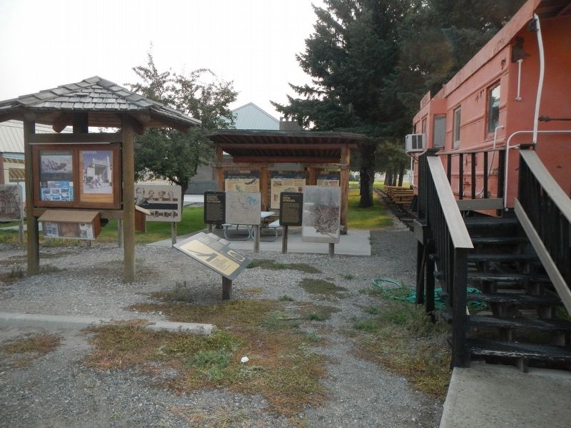
(Three panels are located at the Three Forks Chamber of Commerce kiosk:)
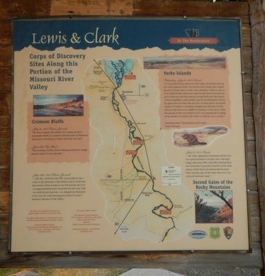
Corps of Discovery Sites Along this Portion of the Missouri River Valley
Crimson Blufffs
July 24, 1895 (Lewis Journal)
"Set out at sunrise; the current very strong; passed a remarkable bluff of a crimson colored earth on Starboard intermixed with Stratas of black and brick red slate."
July 24th (Sgt. Gass)
"This morning was fine, and we early prosecuted our voyage; passed a bank of very red earth..."
July 24th, 1805 (Clark Journal)
"...fine day wind from the NW. I proceeded on up a creek on the derection of the Indian road at 10 oClock discovered a horse 6 miles to my left towards the river as I approached the horse found him fat and verry wild we could not get near him, we changed our Derection to the river for water having previously Crossed 5 handsom Streams in One Valley."
Yorks Islands
Wednesday July 24, 1805 (Lewis)
"we saw many beaver and some otter today: the former dam up the small channels of the river between the islands and compell the river in these parts to make other channels, which as soon as it has effected that which was stoped by the beaver becomes dry and is filled up with mud sand grave and driftwood, the beaver is then compelled to seek another spot for his habitation wher(e) he again erects his dam. thus the river in many places among the clusters of islands is constantly changing the direction of such sluices as the beaver are capable of stoping or of 20 yds in with. this anamal is that way I believe to be very instrumental in adding to the number of islands with which we find the river crouded."
(Sometime later, Clark penned on his map:)
Yorks 8 Islands
July 25. 1805 (Lewis)
"... the valley appeared to termineate and the river was again hemmed in on both sides with high cagily and rocky cliffs, soon after entering these low mountains we passed a number of fine bold springs which burst out underneath the Land, clifts near the edge of the water; they wer very cold and freestone water."
Second Gates of the Rocky Mountains
All trail and campsites locations are approximate. Some lie on private land.
For more information on viewing the Lewis and Clark trail in Broadwater County contact: Crimson Bluffs Chapter, Lewis & Clark Trail Heritage Foundation, Inc., 415 S. Front Street, Townsend, MT 59644, (406)226-3425
For more information: Broadwater County Museum, 133 N. Walnut, Townsend MT 59644, Phone 406-266-5252, website: http;//www.townsendvalley.com
Townsend Chamber of Commerce, (406)266-4101
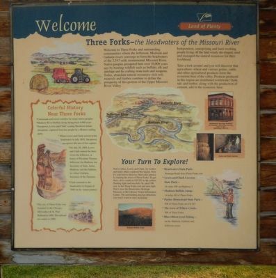
Welcome to Three Forks and surrounding communities where the Jefferson, Madison, and Gallatin rivers converge to form the headwaters of the 2,54-mile monumental Missouri River. Native peoples prospered here over 10,000 years ago by hunting wildlife such as buffalo, elk and antelope and by crafting stone tools and weapons. Today, abundant natural resources - rich soil, minerals, and timber combine to define the prosperity of this portion of the Upper Missouri River Valley.
Independent, enterprising and hard-working people living off the land wisely developed, used and managed the natural resources for their livelihood.
Take a look around and you will discover that agriculture - wheat and various grains, cattle, and other agricultural products form the economic base of the valley. Products produced in this region are distributed worldwide! Gold, talc, and timber, along with the production of cement, add to the economic base.
Colorful History Near Three Forks
Crossroads and travel corridor for many native peoples
Madison River Buffalo Jump dating back 4,000 years
Sacajawea, Lewis and Clark's young Shoshone Indian interpreter, captured from here people by a Hidatsa

Photographed By Barry Swackhamer, July 27, 2021
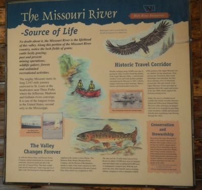
3. The Missouri River - Source of Life panel
Captions: (middle left) Ice sailing on the Canyon Ferry Reservoir; (center right) Over 25 ferryboats crossed this 100-mile stretch; (upper right) Bald eagles can be seen feeding on the fish at Canyon Ferry Reservoir.
When Lewis and Clark arrived at the headwaters in July, 1805, Sacajawea recognized the area of her capture.
On July 28, 1805, Lewis and Clark named the three rivers the Jefferson, in honor of President Thomas Jefferson; the Madison, for Secretary of State, James Madison; and the Gallatin, for Albert Gallatin, Secretary of the Treasury.
Clark returned the headwaters in August of 1806 on his return journey.
The city of Three Forks was founded by the Chicago, Milwaukee & St. Paul Railroad in 1908. The railroad era ended in 1980.
Your Turn to Explore!
Native tribes, Lewis and Clark, fur traders and many others explore this region. Now it's your turn to discover. Start your journey by touring the town of Three Forks. To get there, drive south on US 287 to the yellow flashing light and turn left. Or, take I090 east to Three Forks exit and turn right. Don't miss the Headwaters Heritage Museum, or there Caboose Visitors Center. The surrounding area has attractions you won't want to miss including:
Headwaters State Park - Frontage Road from Three Forks exit
Lewis and Clark Caverns State Park - 16 miles SW on Highway 2
Madison Buffalo Jump - 14 miles SE of Three Forks
Parker Homestead State Park - SW on Three Forks on US 287
The town of Willow Creek - SW of Three Forks
Blue ribbon trout fishing - on the Madison, Gallatin and Jefferson rivers.
No doubt about it, the Missouri River is the lifeblood of this valley. Along this proton of the Missouri River country, notice the lush fields of grain; cattle lazily grazing; past and present mining operations; wildlife galore; forests and unlimited recreational activities.
The mighty Missouri starts its long 2,547-mile journey eastward to St. Louis at the headwaters near Three Forks where the Jefferson, Madison and Gallatin rives converge. It is one of the longest rivers in the United States, second only to the Mississippi.
The Valley Changes Forever
In 1896 the Helena Water and Electric Power Company started construction of a wood and earth dam, and power plant just above the site of Canyon Ferry. That dam created Lake Sewell which was 7 miles long and 2 to 3 miles wide. Electrical power fro the plant was supplied to the smelter in East Helena. The Montana Water Board, Montana Power Company and the Bureau of Reclamation initiated a study of the water resources in 1941, which led to the construction of the new Canyon Ferry Dam which was completed in 1954. The dam and the 25-mile long Canyon Ferry Reservoir added 155,000 new acres of irrigated land and helped water an additional 82,000 acres of inadequately irrigated land. With the new reservoir came other benefits such as boating, fishing, camping as well as abundant wildlife.
Historic Travel Corridor
Whether trudging along 10,000 years ago or passing by today, travelers found this portion of the Upper Missouri Valley a well traveled corridor. Lewis and Clark pushed, paddled and pulled up the Missouri in 1805, with fur trappers following in their footsteps. Miners, farmers and homesteaders came next.
This portion of the Upper Missouri was too shallow for big steamboats. Near present-day Townsend, three small steamships were launched, but they never returned. Over 25 ferryboats crossed this 100-mile stretch of the Upper Missouri. Ferries provided an important link to the wagon road system in the late 1800s which supplied the booming mining towns.
Today, this area is a modern travel corridor that whisks travelers between Glacier and Yellowstone National Parks. The river valley still plays an integral role in the lives of people by providing water, recreation, wildlife and relaxation from the slow meandering water flowing through the valley.
Conservation and Stewardship
This portion of the Upper Missouri River Valley is still a pristine natural area of Montana where people continue to use, develop and carefully manage natural resources. Good stewardship is the key factor for long-term conservation. Mining land is being carefully reclaimed; the timber industry practices environmentally sound logging practicers; and farmers and ranchers continue to care for their land so future generations can enjoy and prosper in the valley.
Erected by U.S. Forest Service, National Park Service.
Topics and series. This historical marker is listed in these topic lists: Environment • Exploration • Notable Places. In addition, it is included in the Lewis & Clark Expedition series list.
Location. 45° 53.797′ N, 111° 33.078′ W. Marker is in Three Forks, Montana, in Gallatin County. Marker can be reached from the intersection of North Main Street (State Highway 2) and Cottonwood, on the left when traveling north. The kiosk is located behind the caboose. Touch for map. Marker is at or near this postal address: 110 North Main Street, Three Forks MT 59752, United States of America. Touch for directions.
Other nearby markers. At least 8 other markers are within walking distance of this marker. Native Americans (a few steps from this marker); European Interest in the Missouri (a few steps from this marker); Fur Trade (a few steps from this marker); Louisiana Purchase - 1803 (a few steps from this marker); Lewis & Clark Arrive at the Headwaters July, 1805 (a few steps from this marker); The Fur Trapper (a few steps from this marker); Colter's Run 1808 (a few steps from this marker); Three Forks Post - 1810 (a few steps from this marker). Touch for a list and map of all markers in Three Forks.
Credits. This page was last revised on March 2, 2022. It was originally submitted on March 2, 2022, by Barry Swackhamer of Brentwood, California. This page has been viewed 326 times since then and 19 times this year. Photos: 1, 2, 3, 4. submitted on March 2, 2022, by Barry Swackhamer of Brentwood, California.


