Hastings-on-Hudson in Westchester County, New York — The American Northeast (Mid-Atlantic)
The Ravine, Looking East
⎯⎯⎯
El Barranco, Mirando Hacia El Este
Hastings-on-Hudson, New York
| — | The Museum in the Streets | — |
Photographed by Devry Becker Jones (CC0), March 6, 2022
1. The Ravine, Looking East / El Barranco, Mirando Hacia El Este Marker

The Ravine, Looking East
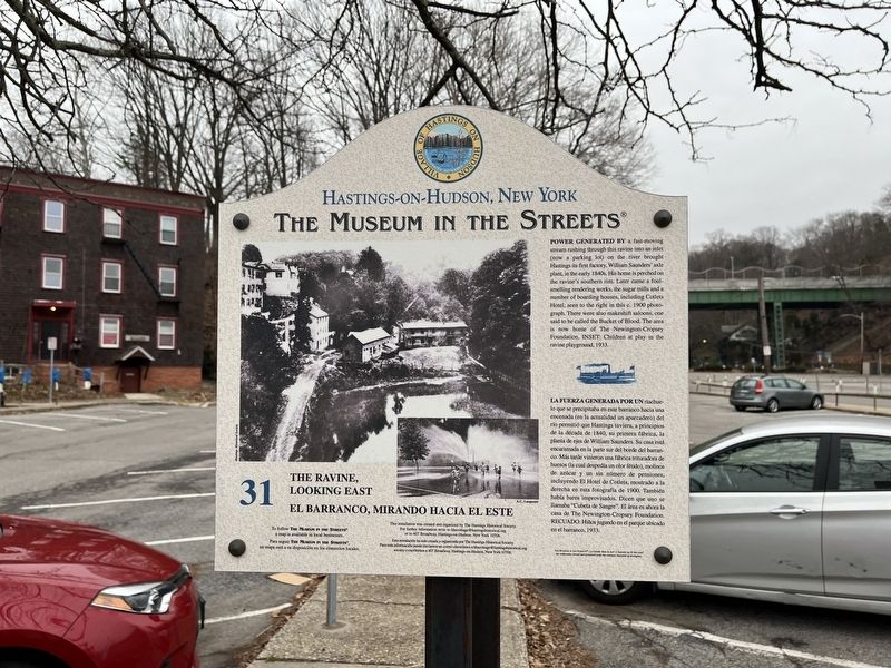
Power generated by a fast-moving stream rushing through this ravine into an inlet (now a parking lot) on the river brought Hastings its first factory, William Saunders' axle plant, in the early 1840s. His home is perched on the ravine's southern rim. Later came a foul-smelling rendering works, the sugar mills and a number of boarding houses, including Cotlets Hotel, seen to the right of this c. 1900 photograph. There were also makeshift saloons, one said to be called the Bucket of Blood. the area is now home of The Newington-Cropsey Foundation. Inset: Children at play in the ravine playground, 1933.
La fuerza generada por un riachuelo que se precipitaba en este barranco hacia una encenada (en la actualidad un aparcadero) del río permitió que Hastings tuiera, a principios de la década de 1840, su primera fábrica, la planta de ejes de William Suanders. Su casa está encaramada en la parte sur del borde del barranco. Más tarde vinieron una fábrica trituradora de huesos (la cual despedía un clor fétido), molinos de azúcar y un sin número de pensiones,
this page online
Erected 2006 by The Museum in the Streets. (Marker Number 31.)
Topics and series. This historical marker is listed in these topic lists: Industry & Commerce • Waterways & Vessels. In addition, it is included in the The Museum in the Streets: Hastings-on-Hudson, New York series list. A significant historical year for this entry is 1900.
Location. 40° 59.648′ N, 73° 53.05′ W. Marker is in Hastings-on-Hudson, New York, in Westchester County. It is on Southside Avenue just north of Cropsey Lane, on the right when traveling north. Touch for map. Marker is at or near this postal address: 134 Southside Ave, Hastings on Hudson NY 10706, United States of America. Touch for directions.

Regionally, this marker is in the Hudson Valley and in the New York City Metropolitan Area. It is also in the American Northeast, in the Mid-Atlantic, and on the
Photographed by Devry Becker Jones (CC0), March 6, 2022
2. The Ravine, Looking East / El Barranco, Mirando Hacia El Este Marker
Other nearby markers. At least 8 other markers are within walking distance of this marker: The Ravine, Looking West / El Barranco, Mirado Hacia El Oeste (here, next to this marker); Hastings-on-Hudson, New York (within shouting distance of this marker); Industrial Hastings / El Hastings Industrial (about 300 feet away, measured in a direct line); The Local Soda Fountain / La Fuente de Soda Local (about 500 feet away); Honor Roll (about 500 feet away); Purple Heart Village (about 500 feet away); Municipal Building / El Edificio Municipal (about 500 feet away); Warburton Avenue / Avenida Warburton (about 600 feet away). Touch for a list and map of all markers in Hastings-on-Hudson.
Credits. This page was last revised on August 26, 2026. It was originally submitted on March 13, 2022, by Devry Becker Jones of Washington, District of Columbia. This page has been viewed 179 times since then and 16 times this year. Photos: 1, 2. submitted on March 13, 2022, by Devry Becker Jones of Washington, District of Columbia.
