Louisa in Louisa County, Virginia — The American South (Mid-Atlantic)
Louisa Court House
Raiders Intercepted
— The Battle of Trevilian Station —
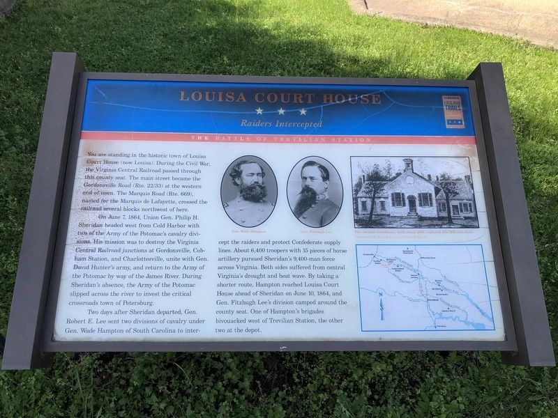
You are standing in the historic town of Louisa Court House (now Louisa). During the Civil War, the Virginia Central Railroad passed through this county seat. The main street became the Gordonsville Road (Rte. 22/33) at the western end of town. The Marquis Road (Rte. 669), named for the Marquis de Lafayette, crossed the railroad several blocks northwest of here.
On June 7, 1864, Union Gen. Philip H. Sheridan headed west from Cold Harbor with two of the Army of the Potomac's cavalry divisions. His mission was to destroy the Virginia Central Railroad junctions at Gordonsville, Cobham Station, and Charlottesville, unite with Gen. David Hunter's army, and return to the Army of the Potomac by way of the James River. During Sheridan's absense, the Army of the Potomac slipped across the river to invest the critical crossroads town of Petersburg.
Two days after Sheridan departed, Gen. Robert E. Lee sent two divisions of cavalry under Gen. Wade Hampton of South Carolina to intercept the raiders and protect Confederate supply lines. About 6,400 troopers with 15 pieces of horse artillery pursued Sheridan's 9,400-man force across Virginia. Both sides suffered from central Virginia's drought and heat wave. By taking a shorter route, Hampton reached Louisa Court House ahead of Sheridan on June 10, 1864, and Gen. Fitzhugh Lee's division camped around the county seat. One of Hampton's brigades bivouacked west of Trevilian Station, the other two at the depot.
Erected by Virginia Civil War Trails.
Topics and series. This historical marker is listed in these topic lists: Railroads & Streetcars • War, US Civil. In addition, it is included in the Virginia Civil War Trails series list. A significant historical month for this entry is June 1765.
Location. 38° 1.488′ N, 78° 0.198′ W. Marker is in Louisa, Virginia, in Louisa County. Marker is at the intersection of West Main Street (U.S. 33) and Elm Avenue, on the right when traveling east on West Main Street. Touch for map. Marker is in this post office area: Louisa VA 23093, United States of America. Touch for directions.
Other nearby markers. At least 8 other markers are within walking distance of this marker. Patrick Henry's Home (here, next to this marker); Second Louisa County Courthouse Threshold (here, next to this marker); Confederate Memorial (a few steps from this marker); In Memory of All Veterans (within shouting distance of this marker); John Mercer Langston Birthplace (within shouting distance of this marker); Historic Louisa (approx. 0.3 miles away); Hugh Hammond Bennett (1881-1960) (approx. 0.3 miles away); Louisa Rail Road track--1837 (approx. 0.3 miles away). Touch for a list and map of all markers in Louisa.
More about this marker

Photographed By Devry Becker Jones (CC0), April 3, 2021
2. Louisa Court House Marker
The marker has experienced moderate weathering but remains legible.
Regarding Louisa Court House. This is one of several markers interpreting the Battle of Trevilian Station, June 11-12, 1864. See the Battle of Trevilian Station Virtual Tour by Markers linked below for additional related markers.
Also see . . . Trevilian Station Battlefield Foundation. The Courthouse is the first stop on a driving tour of the battlefield produced by the foundation. Over 1600 acres of this battlefield have been preserved through the efforts of the foundation and other preservation organizations. (Submitted on January 19, 2008, by Craig Swain of Leesburg, Virginia.)
Credits. This page was last revised on March 21, 2022. It was originally submitted on January 19, 2008, by Craig Swain of Leesburg, Virginia. This page has been viewed 2,946 times since then and 37 times this year. Last updated on March 21, 2022, by James Dean of Chesterfield, Virginia. Photos: 1. submitted on January 19, 2008, by Craig Swain of Leesburg, Virginia. 2, 3. submitted on April 4, 2021, by Devry Becker Jones of Washington, District of Columbia. 4. submitted on January 19, 2008, by Craig Swain of Leesburg, Virginia. • J. Makali Bruton was the editor who published this page.


