Valley Park in St. Louis County, Missouri — The American Midwest (Upper Plains)
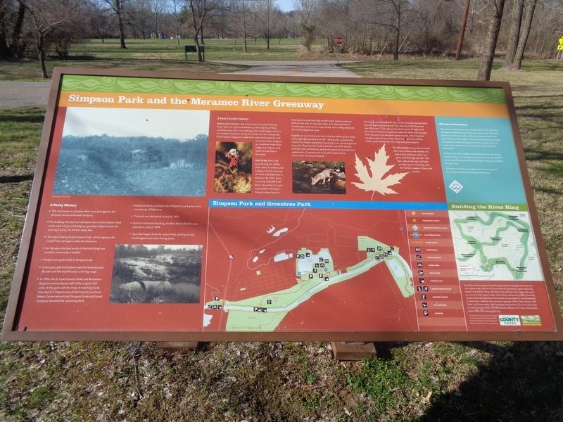
Simpson Park and the Meramec River Greenway
A Rocky History
The area known as Simpson Park once belonged to the Simpson Sand and Gravel Company.
The building of a dam to hold water from Grand Glaize Creek and a sand and gravel dredging operation helped create the existing 72 acre, 25-50 foot deep lake.
The lake is fed by Grand Glaize Creek, which captures the runoff from 22 square miles of urban area.
For 30 years, the land south of Marshall Road was used for construction landfill.
People once paid to fish in Simpson Lake.
In the past, golf enthusiasts used the land between the lake and Marshall Road as a driving range.
In 1976, the St. Louis County Parks and Recreation Department purchased half of the original 148 acres of this park with the help of matching funds from the U.S. Department of the Interior Land and Water Conservation Fund. Simpson Sand and Gravel Company donated the remaining land.
Additional land purchases have helped the park grow to its current size of 206 acres
The park was dedicated on July 6, 1991
Built to withstand flooding, the Blue Heron Pavilion was erected in June of 1994
Taco Bell helped fund the soccer field, parking lot and handicapped accessible fishing docks
A River Corridor Habitat
Beaver and muskrats make their home along the Meramec River. Both are nighttime feeders, so the majority of their activities occur late in the evening. Both build lodges either in the middle of ponds or along the shores of rivers and ponds. While beaver lodges are made from sticks held together with mud that's been slapped on, muskrats make their lodges out of grass and reeds and perhaps a few sticks.
Wild Turkey live in the area. During the 1800s, there were 10 million wild turkeys in North America of which 250,000 lived in Missouri. By 1950, there were only 300,000 birds left in the entire U.S. and only 3,000 in Missouri. Young turkeys hatch in May and June and need high protein food. Insects make up 80% of their diet. As they get older, their diet expands to include grass seed, acorns, oats, wheat, corn, wild grapes and the fruit of dogwood trees.
Coyotes are commonly seen here. Mostly reddish gray in color and weighing anywhere from 30-40 pounds, coyotes help control the rodent population by eating mice, rats and ground squirrels. They also eat crickets, beetles and other insects, and like fruits and berries, wild plums, persimmons and even watermelon. Coyotes howl to let other packs know where their territory is located.
The highly vocal Barred Owl nests in the area and may be heard day and night calling
its loud "hoo, hoo too-hoo; hoo hoo too-hoo,ooh." The calls are heard in a series of eight, and then the owl becomes quiet as it waits for other owls to reply. From its perch, the owl dives upon its prey, which includes meadow voles, shrews, deer mice, rats, squirrels, rabbits, moles, quail, blackbirds, fish, frogs and grasshoppers.
The Silver Maple tree prefers a moist soil, near streams and swamps. Its bark is thin and gray, and it can grow 125 feet high and 60-80 feet wide at the top. Leaf tops are light green and shiny, and the bottoms appear silvery and smooth.
Meramec Greenway
The Meramec Greenway was established in 1975 with the mandate to plan and coordinate the recovery of 108 miles of the lower Meramec River that had deteriorated from years of abuse and neglect. The Meramec River Recreation Association, made up of governments with jurisdictions on the river and area citizens, was formed to lead the restoration.
Today good water quality has been restored, the natural beauty of the river setting is recovering and over 28,000 acres of public parks and conservation areas are available for your use.
To learn more about the Meramec Greenway visit the website: www.meramecgreenway.org
Erected by Saint Louis County Parks and Great Rivers Greenway.
Topics. This historical marker is listed in these topic lists: Animals • Parks & Recreational Areas • Waterways & Vessels. A significant historical month for this entry is June 1994.
Location. 38° 33.226′ N, 90° 27.886′ W. Marker is in Valley Park, Missouri, in St. Louis County. Marker is on Marshall Road east of Simpson Park Road, on the right when traveling east. Marker is located at a parking lot near the trailhead. Touch for map. Marker is at or near this postal address: 1235 Marshall Rd, Valley Park MO 63088, United States of America. Touch for directions.
Other nearby markers. At least 8 other markers are within 2 miles of this marker, measured as the crow flies. West Barretts Tunnel (approx. 1.1 miles away); #39 "Marmora" (approx. 1.1 miles away); #274 (approx. 1.1 miles away); #4700 (approx. 1.2 miles away); #311 (approx. 1.2 miles away); #1365 (approx. 1.2 miles away); #4916 (approx. 1.2 miles away); The "Katy Flyer" (approx. 1.2 miles away).
Also see . . . Simpson Park. From Saint Louis County's Parks website. The fishing docks donated by Taco Bell were unfortunately lost in the 2017 flood. (Submitted on March 28, 2022, by Jason Voigt of Glen Carbon, Illinois.)
Credits. This page was last revised on March 28, 2022. It was originally submitted on March 28, 2022, by Jason Voigt of Glen Carbon, Illinois. This page has been viewed 371 times since then and 55 times this year. Photos: 1, 2. submitted on March 28, 2022, by Jason Voigt of Glen Carbon, Illinois.

