Tacony in Philadelphia in Philadelphia County, Pennsylvania — The American Northeast (Mid-Atlantic)
Tacony / Wissinoming
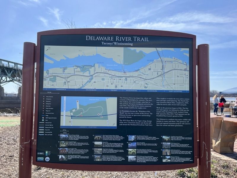
Delaware River Trail
The Delaware River has shaped the culture and economy of Philadelphia for centuries. The area's first residents, the Lenni Lenapi, came here to fish and hunt. European immigrants arrived in the mid-1500s. They built factory towns connected to the outside world by the mighty river.
As Philadelphia became the "Workshop of the World" the river was a victim of this success. The Delaware became an open sewer and breeding-ground for disease.
The 1972 Clean Water Act began a long cleanup of the river. Concerned citizens and elected officials formed the Northeast Riverfront Task Force.
They sought to revitalize the river and its communities through careful planning. the North Delaware Greenway Master Plan, completed in 32005, called for eleven miles of new trails and parks.
Work on the greenway began in 2006. The first new trail segment was dedicated in 2008 near the mouth of the Pennypack Creek. Lardner's Point Park opened in May 2012. Trail segments near the Frankford Boat Launch opened in 2016.
The Delaware is a resilient river-native wildlife still inhabits its waters and shores. This greenway and local and regional restoration projects will conserve these for current and future generations.
❶ Tacony-Palmyra Bridge
Designed by Ralph Modjeski, whose works include the Benjamin Franklin Bridge, located further south. The bridge, which opened in 1929, spurred growth in Northeast Philadelphia.
❷ Campbell Square
Established in 1894 as Allegheny Square, this 2.25 acre passive park is the central public gathering place for the Port Richmond community.
❸ Tacony Music Hall
Built in 1885 as a multi-purpose facility with stores, an auditorium, library, and meeting rooms. The hall hosted lectures by entertainer P.T. Barnum and women's rights activist Susan B. Anthony.
❹ All Saints Episcopal Church
Built in 1854 to replace a 1772 structure, this church was designed by Frank Wills, a noted Gothic Revival architect.
❺ Glen Foerd & Historic River Estates
Built in 1850 by financier Charles Macalester, Glen Foerd was altered by later owner Robert H. Foerderer. Among the finest of the many summer estates that once lined the riverfront. Open to the public.
❻ Pulaski Pier
This 1-acre park offers great fishing views of the river. It is named in honor of Casimir Pulaski. Pulaski was a Polish general who came to Philadelphia to help the Americans during the Revolutionary War.
❼ Tioga Marine Terminal
Managed by the Philadelphia Regional Port Authority, this 116 acre
❽ Historic Tacony Architecture
Tacony is home to the Disston Historic District, a preserved company town founded by saw maker Henry Disston in 1871. The district contains notable residential, commercial, religious and institutional structures.
❾ Port Richmond Churches
Allegheny Avenue is home to significant religious structures including St. Aldabert, Our Lady of Christians, and Nativity BVM, all within blocks of each other.
❿ Betsy Ross Bridge
Opened in 1976, this steel continuous truss bridge is named after the designer of the first American flag.
⓫ Most Holy Redeemer Cemetery
A monumental gatehouse marks the entrance to this cemetery built in Bridesburg in 1887 for Philadelphia's German Catholic population.
⓬ PECO Richmond Generating Station
Neoclassical 'temple' designed by John T. Windrim for the Philadelphia Electric Co. in the early 1920s. The building housed electrical generators powered by coal. The riverfront location allowed coal to be shipped directly to the building.
⓭ Frankford Avenue Bridge William Penn ordered this bridge over the Pennypack Creek built in 1697. It is the oldest continuously used bridge in the United States.
⓮ Holmesburg Prison
Built in 1896 based on the hub-and-spoke plan established at Eastern State Penitentiary on Fairmount Ave. Portions of the prison are still in use.
⓯ Holmesburg Library
Built with funds from steel magnate Andrew Carnegie on land donated by the Trustees of Lower Dublin Academy, this Free Library branch opened in 1907.
⓰ Pleasant Hill Park
Formerly a state fish hatchery and a bathing beach, this park is still a fishing and boating destination. A boat ramp, fishing pier and fishing ponds for children offer something for every angler.
Erected by Philadelphia Parks & Recreation; East Coast Greenway; Delaware River City Corps.; Delaware River Heritage Trail.
Topics and series. This historical marker is listed in these topic lists: Industry & Commerce • Settlements & Settlers • Waterways & Vessels • Women. In addition, it is included in the Carnegie Libraries, and the Susan B. Anthony series lists. A significant historical month for this entry is May 2012.
Location. 40° 0.894′ N, 75° 2.75′ W. Marker is in Philadelphia, Pennsylvania, in Philadelphia County. It is in Tacony. Marker is at the intersection of K&T Trail and Levick Street, on the right when traveling east on K&T Trail. Touch for map. Marker is at or near this postal address: 5202 Levick St, Philadelphia PA 19135, United States of America. Touch for directions.
Other nearby markers. At least 8 other markers are within walking distance of this marker. Tidal Wetlands (within shouting distance of this marker); Tacony-Palmyra Ferry Company (within shouting distance of this marker); Industry Along the River (within shouting distance of this marker); Tacony-Palmyra Bridge (within shouting distance of this marker); Kensington and Tacony Railroad (within shouting distance of this marker); Lardner's Point (within shouting distance of this marker); Lardner's Point Pumping Station (about 300 feet away, measured in a direct line); Bringing Back the River / One Site, Many Ecosystems (about 600 feet away). Touch for a list and map of all markers in Philadelphia.
Credits. This page was last revised on November 23, 2023. It was originally submitted on April 5, 2022, by Devry Becker Jones of Washington, District of Columbia. This page has been viewed 158 times since then and 15 times this year. Photos: 1, 2. submitted on April 5, 2022, by Devry Becker Jones of Washington, District of Columbia.

