Near Naples in Collier County, Florida — The American South (South Atlantic)
How the Dredge Walks
Photographed by Steve Stoessel, April 4, 2022
1. How the Dredge Walks Marker
Inscription.
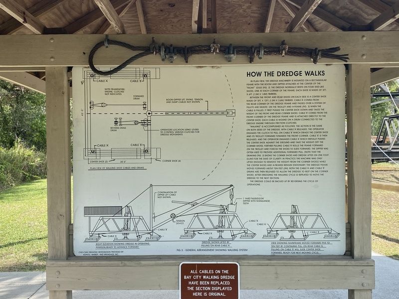
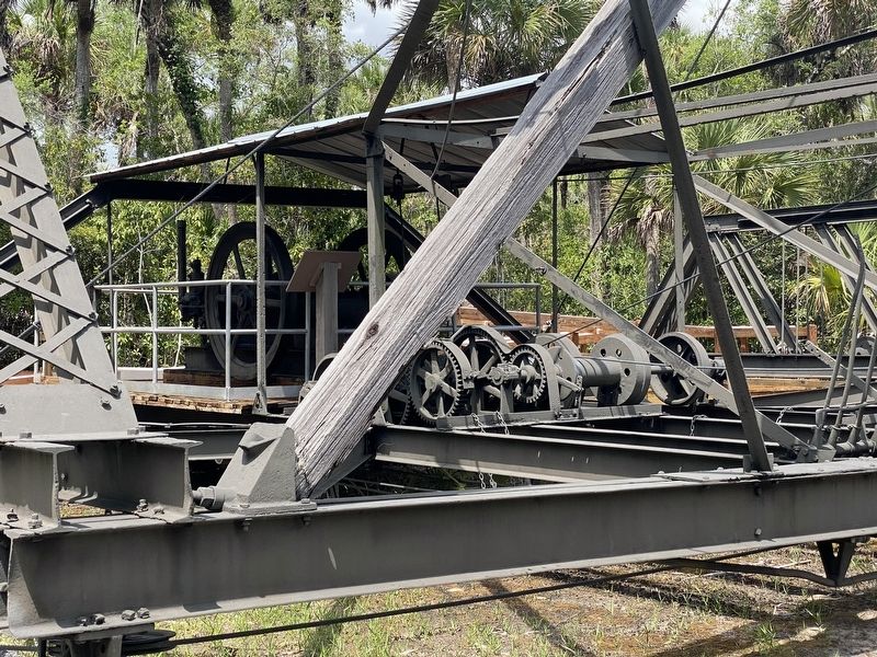
How the Dredge Walks. . , In plan view, the dredge machinery is mounted on a rectangular frame with the boom and dipper attached at the center of the "front” edge (Fig. 3). The dredge normally rests on four skid-like shoes, one at each corner of the frame each shoe is made of 5ft x 6ft (1.5m x 1.8m) timbers., Between the front and rear shoes on each side is a center shoe made of 5ft x 12ft (1.5m x 3.6m) timbers. Cable “A” comes from the rear corner of the dredge frame and passes over a system of pulleys and sheaves on the trolley and a-frame (Fig. 3). When the cable is pulled, it first pushes the center shoe down and takes the weight of the front and rear corner shoes. Cable “B” comes from the front corner of the dredge frame and is attached directly to the center shoe. Each cable is wound on a drum connected to the dredge engine through friction clutches., "Walking” is accomplished as follows. The action is the same on both sides of the dredge. With cable “A” released, the operator engages the clutch to pull on cable “B” which drags the center shoe and its trolley forward towards the front corner. Cable “B” is then released, and the operator engages cable a which initially pushes the center shoe against the ground and take the weight off the corner shoes. Further pulling cable “A” rolls the frame forward on the trolley and forces the shoes to slide forward. The dipper was often used to provide additional forward pull. (Note that the drawing (Fig. 3) shows the corner shoes and dredge lifted on one foot (0.3m) for the sake of clarity. In practice the machine was only lifted enough to remove the weight from the corner shoes.) While the center shoes and A-frames remain stationary, the dredge frame moves forward about ten feet (3m). Both the cable “A” and cable ”B” drums are then released to allow the dredge to rest on the corner shoes. After dredging the walking cycle is repeated to move the dredge to the next section., The dredge could be backed up by reversing the cycle of operations., (below) All cables on the Bay City Walking Dredge have been replaced. The section displayed here is original.
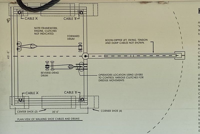
In plan view, the dredge machinery is mounted on a rectangular frame with the boom and dipper attached at the center of the "front” edge (Fig. 3). The dredge normally rests on four skid-like shoes, one at each corner of the frame each shoe is made of 5ft x 6ft (1.5m x 1.8m) timbers.
Between the front and rear shoes on each side is a center shoe made of 5ft x 12ft (1.5m x 3.6m) timbers. Cable “A” comes from the rear corner of the dredge frame and passes over a system of pulleys and sheaves on the trolley and a-frame (Fig. 3). When the cable is pulled, it first pushes the center shoe down and takes the weight of the front and rear corner shoes. Cable “B” comes from the front corner of the dredge frame and is attached directly to the center shoe. Each cable is wound on a drum connected to the dredge engine through friction clutches.
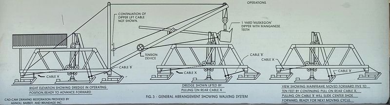
"Walking” is accomplished as follows. The action is the same on both sides of the dredge. With cable “A” released, the operator engages the clutch to pull on cable “B” which drags the center shoe and its trolley forward towards the front corner. Cable “B” is then released, and the operator
Click or scan to see this page online
engages cable a which initially pushes the center shoe against the ground and take the weight off the corner shoes. Further pulling cable “A” rolls the frame forward on the trolley and forces the shoes to slide forward. The dipper was often used to provide additional forward pull. (Note that the drawing (Fig. 3) shows the corner shoes and dredge lifted on one foot (0.3m) for the sake of clarity. In practice the machine was only lifted enough to remove the weight from the corner shoes.) While the center shoes and A-frames remain stationary, the dredge frame moves forward about ten feet (3m). Both the cable “A” and cable ”B” drums are then released to allow the dredge to rest on the corner shoes. After dredging the walking cycle is repeated to move the dredge to the next section.
The dredge could be backed up by reversing the cycle of operations.
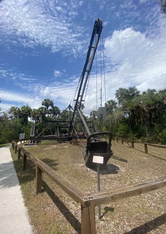
(below) All cables on the Bay City Walking Dredge have been replaced. The section displayed here is original.
Topics. This historical marker is listed in this topic list: Roads & Vehicles.
Location. 25° 59.503′ N, 81° 35.588′ W. Marker
Photographed by Steve Stoessel, April 4, 2022
2. Plan View of Walking Shoe and Cables
is near Naples, Florida, in Collier County. It can be reached from Tamiami Trail East (U.S. 41) south of San Marco Road (County Route 92), on the right when traveling south. Located in Collier-Seminole State Park. Touch for map. Marker is at or near this postal address: 20200 Tamiami Trail East, Naples FL 34114, United States of America. Touch for directions.
Regionally, this marker is on Florida’s Gulf Coast. It is also in the American South and on the Gulf Coast. Globally, it is in the North Atlantic Region, North America, a Gulf of Mexico state, the Western Hemisphere, the Western World, and the Anglosphere. Historically, it finds itself in what was once New Spain, the territory of the Mississippian Culture, one of the Confederate States of America, and the Antebellum South.
5. Clutch and Cable Mechanisms of the Walking Dredge
Credits. This page was last revised on April 26, 2022. It was originally submitted on April 5, 2022, by Steve Stoessel of Niskayuna, New York. This page has been viewed 331 times since then and 35 times this year. Photos:1, 2, 3, 4, 5. submitted on April 6, 2022, by Steve Stoessel of Niskayuna, New York. • Bernard Fisher was the editor who published this page.