Natchez in Adams County, Mississippi — The American South (East South Central)
A Canal Street Neighborhood
Un quarter de Canal Street
— Fort Rosalie —
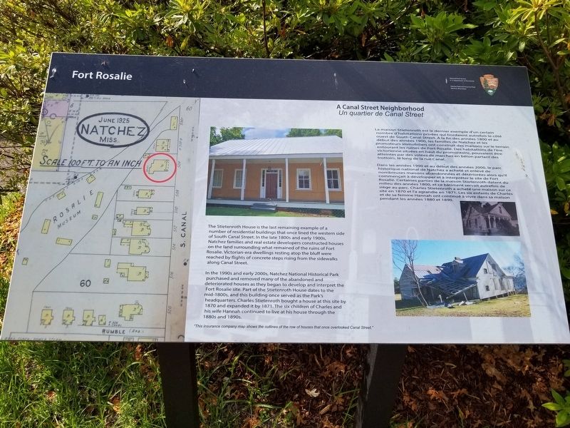
The Stietenroth House is the last remaining example of a number of residential buildings that once lined the western side of South Canal Street. In the late 1800s and early 1900s, Natchez families and real estate developers constructed houses on the land surrounding what remained of the ruins of Fort Rosalie. Victorian-era dwellings resting atop the bluff were reached by flights of concrete steps rising from the sidewalks along Canal Street. In the 1990s and early 2000s, Natchez National Historical Park purchased and removed many of the abandoned and deteriorated houses as they began to develop and interpret the Fort Rosalie site. Part of the Stietenroth House dates to the mid-1800s, and this building once served as the Park's headquarters. Charles Stietenroth bought a house at this site by 1870 and expanded it by 1871. The six children of Charles and his wife Hannah continued to live at his house through the 1880s and 1890s.
"This insurance company map shows the outlines of the row of houses that once overlooked Canal Street."
La maison Stietenroth est le dernier d'un certain nombre d'habitations privées qui bordaient autrefois le côté ouest de South Canal Street. À la fin des années 1800 et au début des années 1900, les familles de Natchez et les promoteurs immobiliers ont construit des maisons sur le terrain entourant les ruines de Fort Rosalie. Des habitations de l'ère victorienne situées en haut du promontoire, pouvaient être atteintes par des volées de marches en béton partant des trottoirs, le long de la rue Canal. Dans les années 1990 et au début des années 2000, le parc historique national de Natchez a acheté et enlevé de nombreuses maisons abandonnées et détériorées alors qu'il commençait à développer et à interpréter le site de Fort Rosalie. Certaines parties de la maison Stietenroth datent du milieu des années 1800, et ce bâtiment servait autrefois de siège au parc. Charles Stietenroth a acheté une maison sur ce site en 1870 et l'a agrandie en 1871. Les six enfants de Charles et de sa femme Hannah ont continué à vivre dans sa maison pendant les années 1880 et 1890.
Erected by National Park Service, US Department of the Interior, Natchez National Historical Park.
Topics. This historical marker is listed in these topic lists: Forts and Castles • Roads & Vehicles • Settlements & Settlers. A significant historical year for this entry is 1870.
Location. 31° 33.482′ N, 91° 24.525′ W. Marker is in Natchez, Mississippi, in Adams County. Marker is on South Canal Street south of D.A. Biglane Street, on the right when traveling south. Touch for map. Marker is in this post office area: Natchez MS 39120, United States of America. Touch for directions.
Other nearby markers. At least 8 other markers are within walking distance of this marker. Fort Rosalie Revisited (within shouting distance of this marker); Ft. Rosalie (Ft. Panmure) (within shouting distance of this marker); Bernardo de Gálvez (within shouting distance of this marker); Rosalie Cemetery (about 600 feet away, measured in a direct line); Fort Rosalie (about 600 feet away); The Spanish Lay Out a Permanent Town (about 600 feet away); The British Assume Control and Shelter Tories (about 700 feet away); The Natchez Revolt (about 700 feet away). Touch for a list and map of all markers in Natchez.
Credits. This page was last revised on April 22, 2022. It was originally submitted on April 22, 2022, by Cajun Scrambler of Assumption, Louisiana. This page has been viewed 247 times since then and 34 times this year. Photos: 1, 2. submitted on April 22, 2022, by Cajun Scrambler of Assumption, Louisiana.

