Near Blue Earth in Faribault County, Minnesota — The American Midwest (Upper Plains)
Water Wisdom
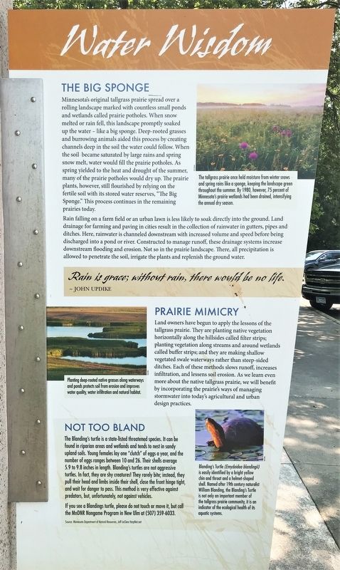
Minnesota's original tallgrass prairie spread over a rolling landscape marked with countless small ponds and wetlands called prairie potholes. When snow melted or rain fell, this landscape promptly soaked up the water – like a big sponge. Deep-rooted grasses and burrowing animals aided this process by creating channels deep in the soil the water could follow. When the soil became saturated by large rains and spring snow melt, water would fill the prairie potholes. As spring yielded to the heat and drought of the summer, many of the prairie potholes would dry up. The prairie plants, however, still flourished by relying on the fertile soil with its stored water reserves, "The Big Sponge." This process continues in the remaining prairies today.
Rain falling on a farm field or an urban lawn is less likely to soak directly into the ground. Land drainage for farming and paving in cities result in the collection of rainwater in gutters, pipes and ditches. Here, rainwater is channeled downstream with increased volume and speed before being discharged into a pond or river. Constructed to manage runoff, these drainage systems increase downstream flooding and erosion. Not so in the prairie landscape. There, all precipitation is allowed to penetrate the soil, irrigate the plants and replenish the ground water.
Caption:
The tallgrass prairie once held moisture from winter snows and spring rains like a sponge, keeping the landscape green throughout the summer. By 1980, however, 75 percent of Minnesota's prairie wetlands had been drained, intensifying the annual dry season.
Rain is grace; without rain, there would be no life. ~ John Updike
Prairie Mimicry
Land owners have begun to apply to lessons of the tallgrass prairie. They are planting native vegetation horizontally along the hillsides called filter strips; planting vegetation along streams and around wetlands called buffer strips; and they are making shallow vegetated swale waterways rather than steep-sided ditches. Each of these methods slows runoff, increases infiltration, and lessens soil erosion. As we learn even more about the native tallgrass prairie, we will benefit by incorporating the prairie's ways of managing stormwater into today's agricultural and urban design practices.
Caption:
Planting deep-rooted native grasses along waterways and ponds protects soil from erosion and improves water quality, water infiltration and natural habitat.
Not Too Bland
The Blanding's turtle is a state-listed threatened species. It can be found in riparian areas and wetlands and tends to nest in sandy upland soils. Young females lay one "clutch" of eggs a year, and the number of eggs ranges between 10 and 26. Their shells average 5.9 to 9.8 inches in length. Blanding's turtles are not aggressive turtles. In fact, they are shy creatures! They rarely bite; instead, they pull their head and limbs inside their shell, close the front hinge tight, and wait for danger to pass. This method is very effective against predators, but unfortunately, not against vehicles.
If you see a Blandings turtle, please do not touch or move it, but call the MnDNR Nongame Program in New Ulm at (507) 359-6033.
Source: Minnesota Department of Natural Resources, Jeff LeClere HerpNet.net
Caption:
Blanding's Turtle (Emydoidea blandingii) is easily identified by a bright yellow chin and throat and a helmet-shaped shell. Named after 19th century naturalist William Blanding, the Blanding's Turtle is not only an important member of the tallgrass prairie community, it is an indicator off the ecological health of its aquatic systems.
Tallgrass Prairie
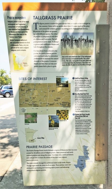
Tallgrass prairie is named for grass species that can reach six feet in height by late summer. Some call it an upside-down forest because much of the plant and animal life is below ground. According to the National Park Service, 80 percent of the plants are grasses; up to 60 different species. The other 20 percent is composed of wild flowers, lichens and liverworts. The tallgrass prairie is never static. It changes as grasses and wildflowers bloom and fade throughout the seasons.
Fire has always been a friend to the prairie. It is both a natural process and a tool used today by restoration professionals to maintain the natural diversity of the prairie. It removes thatch and litter that can help new prairie plants find a place to grow.
Caption:
Some prairie roots extend more than 15 feet underground and provide many environmental benefits. They control erosion, filter water, resist growth of non-native plants and enrich the topsoil when they decompose. These dense root masses also allow the plants to resist the effects of drought.
Prairie ecosystem
Tallgrass prairie is one of the most endangered and fragmented ecosystems in North America. It once stretched from Saskatchewan to Mexico and from east of the Mississippi River west to the Central Great Plains.
Before European settlement, this ecosystem covered one-third of Minnesota. Today, only one percent of the state's original tallgrass prairie remains.
Sites of Interest
1 Dodd-Ford Historic Bridge
This steel, Pratt-truss highway bridge with wood plank deck is listed on the National Register of Historic Places. Constructed in 1901, it is among the state's earliest remaining examples of the overhead Pratt type design.
One mile southwest of Amboy
2 Myre-Big Island State Park
Walk or bike the paved Blazing Star State Trail as it winds through the park's Oak savanna, prairie and lakeshore landscapes to a glacial esker. Enjoy wildflowers and song, shore and wading birds. Also visit the 116-acre Big Island, a mature maple-basswood forest that was protected by Albert Lea Lake from fires that swept over the area.
Three miles southeast of Albert Lea.
3 Shooting Star Prairie Scientific & Natural Area (SNA) and State Trail
This 22-mile paved prairie trail highlights native tall grasses and wildflowers. It passes by several interpretive and recreational areas including the Shooting Star Prairie SNA which was named for the prairie wildflower that once grew here. This small tallgrass prairie remnant survives on abandoned Milwaukee Railroad land.
4.5 miles northwest of LeRoy.
Prairie Passage
The Prairie Passage Route travels through a region of Minnesota that was once covered by 18 million acres of tallgrass prairie. Many preserved and newly restored prairies exist along this route. Visit these sites, and local historic and cultural sites, to learn the stories of this once vast tallgrass prairie ecosystem.
The route extends through five additional states to the south. Prairie Passage signs mark the route in all six states. These partner states are dedicated to protecting and restoring native prairie and educating others about tallgrass prairies.
Topics. This historical marker is listed in these topic lists: Animals • Environment. A significant historical year for this entry is 1980.
Location. 43° 39.526′ N, 94° 6.744′ W. Marker is near Blue Earth, Minnesota, in Faribault County. Located at Blue Earth Rest Area - Eastbound on Interstate 90. Touch for map. Marker is in this post office area: Blue Earth MN 56013, United States of America. Touch for directions.
Other nearby markers. At least 6 other markers are within 16 miles of this marker, measured as the crow flies. A Golden Dedication for I-90 (within shouting distance of this marker); Exploring Southwestern Minnesota (within shouting distance of this marker); The Prairie's Gifts (approx. 0.4 miles away); A Golden Dedication for I-90 / Minnesota Agriculture (approx. 0.4 miles away); Pixley (approx. 10.7 miles away); Nashville Center (approx. 15.3 miles away).
Credits. This page was last revised on April 23, 2022. It was originally submitted on April 23, 2022. This page has been viewed 113 times since then and 12 times this year. Photos: 1, 2, 3, 4. submitted on April 23, 2022.


